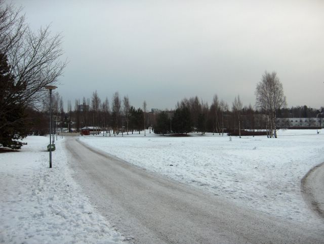
Kuvan tilanteessa vahva korkeapaine oli vallinnut jo muutaman päivän ajan vuodenvaihteen sateisen ja lauhan jakson jälkeen (etelä- ja lounaistuulet). Pakkanen oli kuitenkin tässä korkeapainetyypissä (keskileveysasteiden ilmamassan korkeapaine) heikkoa ja sumupilvet tyypillisiä. Kuvassa niistä on hyvin ohutkerroksinen esimerkki ja niistä satoi ajoittain hyvin heikosti lunta. Korkeapaineen pohjoispuolitse pääsi Lappiin tyypillisesti suojasääilmaa länsituulten mukana. Pakkanen oli kuvauspaikalla päivän aikana -2,2 ja -0,7 asteen välillä. Vuodenvaihteen lauhat säät toivat suojasään, mutta samalla myös lisää lunta. Niinpä lumipeite säilyi edelleen. Aikaisemmasta märästä suojasäästä on kuvassa merkkinä jäiseksi jäätynyt puistokäytävä. Säätilanne: valitse 6.1.2006; Wetter3 A. Wetter3 B.
In the picture a strong high pressure had been dominated for a couple of days after a rainy and mild period at the turn of the year (south and southwesterly winds). However the frost was weak in this type of high pressure (the high pressure of the middle latitude air mass) and stratus clouds were typical. Very thin layered example of those are shown in the picture and they gave very slight snowing from time to time. Along the northern side of the high pressure a mild thaw air flowed typically into Lapland from the west. At the photoshooting scene the temperature was between -2,2 C and - 0,7 C during the day. The mild weather at the turn of the year brought thaw, but also more snow. Therefore the snowcover remained further. As a mark for the previous wet thaw the path is frozen icy in the photo. Weather condition: choose 6.1.2006; Wetter3 A. Wetter3 B.
Helsingin Puistolan säätilasto tammikuussa 2006 - Weather chart of Puistola, Helsinki in January 2006.
Flickr 1 Flickr 2

posted by Mika at
11:06 AM
![]()


0 Comments:
Post a Comment
<< Home