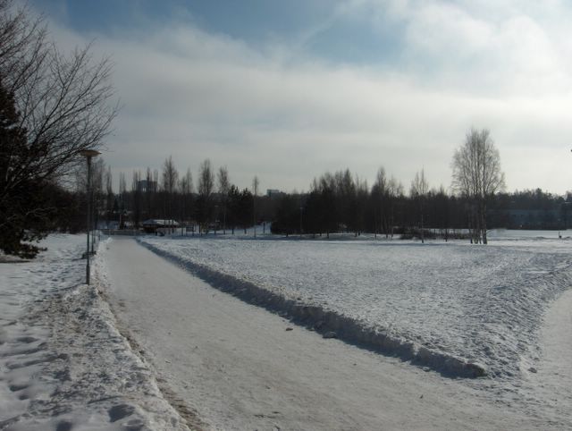
Vahva korkeapaine oli edelleen Suomen yllä ulottuen Venäjältä Atlantille. Itäkaakkoinen tuuli oli heikkoa ja sää päivällä jo vähän keväistä noiden sumupilvien vähennyttyä; ylin lämpötila oli kuitenkin vielä -1,9 astetta pakkasella. Edellisessä kuvassa sumupilvet olivat vielä paksuja, mutta yhtenä kevään merkkinä tässä nähdään voimistuneen auringon paisteen vaikutus, joka haihdutti sumupilviä jo melko hyvin pois päivän aikana. Routa oli tässä vaiheessa yhä n. 50cm syvää, joten suuria muutoksia ei enää ollut tullut pakkasista huolimatta. Lumipeitteen sulamista oli tapahtunut parhaiten aurinkoisilla etelärinteillä, joilla maa oli tässä vaiheessa jo paikoin paljastunut. Tyypillisesti maaliskuussa lumipeite muodostuu tällä tavalla epäyhtenäiseksi riippuen kunkin maan kohdan auringonvalon saannista. Säätilanne: valitse 15.3.2006. Wetter3 A. Wetter3 B.
The strong high pressure was further over Finland reaching from Russia to Atlantic. A east-southeasterly wind was weak and the weather allready slightly springlike in the afternoon after those stratus clouds had been decreased; the maximun temperature was yet -1,9 C freezing though. In the previous picture the stratus clouds were thick, but in here we see as a one sign of spring the strengthened power of the sunshine's effect, which evaporated allready rather easily the stratus clouds away during the day. The soil frost was still at this stage about 50cm deep and therefore big changes hadn't been appeared anymore despite the frosts. The melting of the snowcover had been happened the best in sunny southern slopes, where the ground had allready been exposed locally. Typically during March the snowcover becomes in this way uneven depending of the sunlight supply on every spot of ground. Weather condition: choose 15.3.2006; Wetter3 A. Wetter3 B.
Helsingin Puistolan säätilasto maaliskuussa 2006 - Weather chart of Puistola, Helsinki in March 2006.
Flickr 1 Flickr 2

posted by Mika at
11:17 AM
![]()


0 Comments:
Post a Comment
<< Home