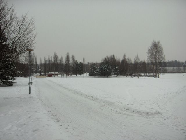
Nyt kuvauspaikalle ulottui heikko lumisadealue lounaassa olleesta matalapaineesta. Lunta satoi silti lähes olemattomasti. Pakkanen kuitenkin lauhtui edelleen ollen päivän aikana lauhimmillaan -8,7 astetta. Pilvilajeina taivaalla olivat sadepilvet, mutta tällaisessa pakkasilmassa ne muistuttivat sadepilvien seassa myös olleita sumupilviä ja kumpukerrospilviä; tuloksena oli melko tasaisen harmaa pilvikerros. Tässä kuvassa nähdään myös, kuinka lunta oli edelleen jäänyt alueen havupuihin kuun alun lumisateista, vaikka lumityyppi oli helposti varisevaa pakkaslunta; tässä vaiheessa lumi oli jo tiivistynyt hieman ja sen myötä lumikokkareet olivat vähän jähmeämpiä. Säätilanne: valitse 9.2.2006; Wetter3 A. Wetter3 B.
Now a weak area of snowfall had reached the scene from the low pressure situated in the southwest. It snowed allmost nothing though. However the temperature got milder further more and it was -8,7 C at highest during the day. The cloud types in the sky were nimbostratus clouds, but during this kind of frosty weather they resembled stratus clouds and stratocumulus clouds, which were also among the nimbostratus clouds; rather evenly grey layer of clouds was the result. In this picture we see also, how there was snow of the precipitation at the start of the month remaining on the conifer trees of the area, allthough the snow type was easily shattered dry frosty snow; at this phase the snow had been allready compressed a little and due to that the lumps of snow had been turned a bit more stiffer. Weather condition: choose 9.2.2006; Wetter3 A. Wetter3 B.
Helsingin Puistolan säätilasto helmikuussa 2006 - Weather chart of Puistola, Helsinki in February 2006.
Flickr 1 Flickr 2

posted by Mika at
11:45 AM
![]()


0 Comments:
Post a Comment
<< Home