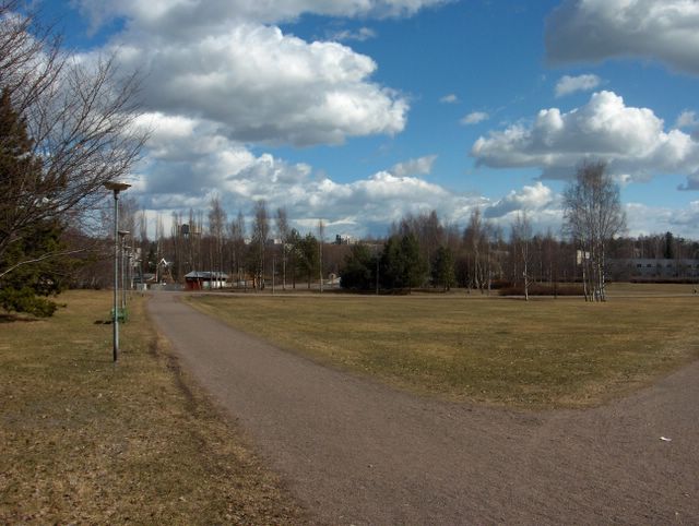
Nyt pohjoistuuli oli voimistunut melko voimakkaaksi edellisen päivän matalapaineen siirryttyä täksi päiväksi Suomen itäpuolelle. Ilmamassa ei kuitenkaan viilentynyt aikaisemmasta, vaan nyt päivälämpötila ylitti ensimmäisen kerran tällä seudulla +10 asteen (ylin lukema oli +10,1 astetta), kun aurinko pääsi jälleen paremmin esille iltapäivällä. Yöllä ei ollut pakkasta tuulen ja pilvien takia. Kuvassa nähdään runsaasti tuulen mukana nopeasti seilanneita kumpupilviä, jotka olivat tyypillisiä tässä viileässä polaarisessa ilmamassassa. Ne paljastivat kevään edistyneen jo pitkälle termiikin kertomana. Pohjoistuulen takia merituuli kumoutui, joten pilvet seilasivat myös meren ylle. Nurmikot näyttivät tässä vaiheessa kaikkein ruskeimmilta juuri ennen uuden kasvun alkua, kun korret olivat kuivuneet. Sen takia ruohikkopalojen vaara kasvoi. Tässä vaiheessa lunta ei enää ollut joitakin hyvin yksittäisiä varjopaikkoja lukuun ottamatta, mutta Etelä-Suomen järvissä ja Suomenlahdessa oli edelleen haurasta jäätä monin paikoin. Jäät olivat muuttuneet nyt tyypillisesti sohjoisiksi kerroksiksi; ne näkyvät tumman vihertävän harmaina sinisen veden päällä, kun taivas on selkeä - osittain selkeä. Jokien kevättulvat olivat kääntyneet laskuun. Säätilanne: valitse 21.4.2006; Wetter3 A. Wetter3 B.
Now a northerly wind had been picked up as the low pressure of the previous day moved to the eastern side of Finland for this day. However the air mass didn't turn cooler than before, but the afternoon temperature was topped +10 C for the first time in this area, because the sun was exposed again better in the afternoon. At night there wasn't frost due to clouds and the wind. In the picture we see plenty of cumulus clouds floated in a fast pace with the wind. They were typical in this cool and polaric airmass, which revealed that the spring had advanced allready far as told by the thermal. The sea breeze was subverted by the northerly wind and therefore the clouds were floating also over the sea. The lawns looked at this stege the most brown as the straws had been dried. Due to that a risk of grassfires increased. At this time there weren't snow anymore not counted for very single spots in shadows, but there were brittle ice left in many places in lakes of southern Finland and in The Gulf Of Finland. The ice had been turned now typically into slushy layers; they appear as dark and greenish grey on the surface of the blue water, when the sky is clear - partly clear. The spring floods of rivers had been started to dissipate. Weather condition: choose 21.4.2006; Wetter3 A. Wetter3 B.
Helsingin Puistolan säätilasto huhtikuussa 2006 - Weather chart of Puistola, Helsinki in April 2006.
Flickr 1 Flickr 2

posted by Mika at
3:23 PM
![]()


0 Comments:
Post a Comment
<< Home