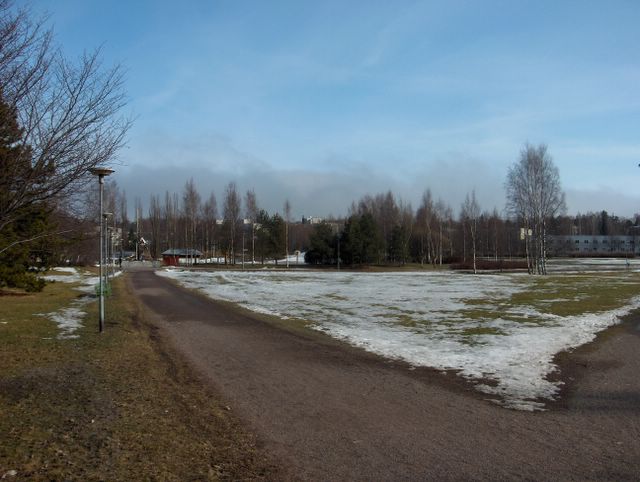
Alkaneen kevään lämpimin päivä tähän mennessä oli ollut 9. huhtikuuta, jolloin päivälämpötila ennen lännestä saapunutta sadealuetta oli +7,1 astetta. Edellisestä kuvasta lukien Suomen länsipuolella oli matalapaine, joka kierrätti sadealueita (sekä vettä että rantää) Etelä-Suomen yli koilliseen. Samalla sää lämpeni vähän. Pari päivää ennen tämän kuvan tilannetta ko. matalapaine heikentyi Suomen ylle uuden matalan asettuessa itään. Eteläpuolelle oli nyt vahvistunut pieni korkeapaine. Sää oli kuvassa siten untuvapilviä lukuun ottamatta selkeä, mutta kylmän ja vielä suureksi osaksi jäisen Suomenlahden takia vallinneessa merituulessa (lounaistuuli) merellä syntyneet sumulautat (kylmän alustan päällä ollut leudompi ilmamassa) ajautuivat ajoittain rannikolle, joita nähdään kuvan taivaanrannassa. Niiden etäisyys kuvaajaan oli vain n. 1 km. Lumipeite oli sulanut nyt nopeammin, koska vettäkin oli satanut ja aurinko lämmitti n. +5 asteen lämmössä tehokkaasti eri pintoja. Routa oli alkanut sulaa myös maan päältä käsin lumettomilla kohdilla. Puistokäytävä alkoi kuivua paikoin paremmin, koska sen alla oleva routa oli sulanut niiltä kohdilta kokonaan. Säätilanne: valitse 12.4.2006; Wetter3 A. Wetter3 B.
The warmest day of the beginned spring so far had been at the 7th of april, when the temperature at noon before the precipitation area arriving from the west was +7,1 C. From the previous picture onwards there was a low pressure in the western side of Finland, which circulated precipitation areas (both rain and sleet) over southern Finland to the northeast. At the same time the weather got warmer a bit. A couple of days before the situation of this picture that low pressure weakened over Finland as a new low pressure settled in the east. In the south there was now strengthened a small high pressure. The weather was therefore clear in the picture not counted for the cirrus clouds, but in the prevailed sea breeze (a southwesterly wind) due to cold and for the most part yet frozen The Gulf Of Finland fog patches formed at sea (the milder air over the cold surface) were floating to the coast, which can be seen in the photo in the horizon. The distance between them and the photographer was only about 1 kilometer. The snowcover had been melted faster now, because it had also been rained and the sun warmed up different surfaces effectively when the temperature was about +5 C. The soil frost had been started to melt also from over the ground. The path in the park started to dry up locally better, because the soil frost underneath of it had been melted completely from those spots. Weather condition: choose 12.4.2006; Wetter3 A. Wetter3 B.
Helsingin Puistolan säätilasto huhtikuussa 2006 - Weather chart of Puistola, Helsinki in April 2006.
Flickr 1 Flickr 2

posted by Mika at
4:08 PM
![]()


0 Comments:
Post a Comment
<< Home