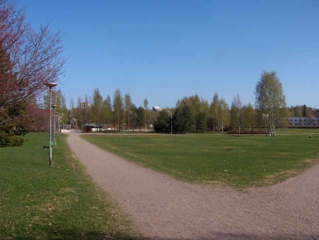
Edellisten kuvien tilanteesta sää oli lämmennyt tätä kuvaa edeltävään päivään asti koko ajan ja tuolloin lämpöaalto oli huipentunut niin, että tällä alueella ylin lämpötila oli jopa +24,8 astetta ja sisämaa-alueilla +25 astetta (helleraja) oli ylitetty ja kahtena edellisenäkin päivänä. Öisin lämpötila oli +5 asteen vaiheilla eikä hallaa ollut. Lämpimän ja aurinkoisen sään aiheutti Suomen ja Skandinavian yllä ollut keskileveysasteiden ilmamassan korkeapaine, jonka painopiste oli kuitenkin siirtynyt tässä vaiheessa länteen ja vähän viileämmät itätuulet olivat alkaneet vaikuttamaan; päivälämpötila jäi nyt vähän alle +20 asteen. Tällä kuvauspaikalla kasvukausi on normaalistikin tähän aikaan hyvällä alulla, mutta nyt se oli kirinyt lämpöaallossa edelle tavanomaisesta; suurimpaan osaan puista niin luonnossa kuin puutarhoissa ja puistoissa oli puhjenneet lehdet ja esim. koivut (Betula sp.) kukkivat nyt runsaasti aiheuttaen paljon siitepölyä ilmaan. Kuvassa ovat seuraavat puulajit: vasemmalla punertavana rusokirsikka (Prunus sargentii), sen takana kontortamänty (Pinus contorta), käytävän päässä pylväshaapaa (Populus tremula "Erecta"), valkorunkoiset puut ovat rauduskoivuja (Betula pendula) ja niiden mukana keskellä kuvaa on metsämäntyjä (Pinus sylvestris). Maiseman vihreyden lisääntyminen oli näinä lämpiminä päivinä päivittäin havaittavaa. Säätilanne: valitse 8.5.2006; Wetter3 A. Wetter3 B.
From the situation of the previous picture onwards the weather had been warming all the time up to the day before of this picture and then this wave of warm air had been culminated in such a way, that in this region the maximum temperature was even +24,8 C and in inland areas +25 C (this is classified in Finland as the limit of heatwave) was topped allready two days earlier as well. At nights the temperature was around +5 C and there wasn't ground frost. The warm and sunny weather was resulted by the high pressure of the middle latitude air mass situated over Finland and Skandinavia. However the center of that high pressure had been moved to the west at this stage and a little cooler easterly winds had been started to affect; the afternoon temperature stayed now a bit under +20 C. In this photoshooting scene the growing season is also normally in a fine start at this time of the year, but now it had been pushed ahead of the average in the warm weather; leaves had been unfolded in most of the trees both in nature and in gardens and parks and for example birches (Betula sp.) were now in bloom shedding very much pollen into the air. In the picture there are the following tree species: on the left in reddish colour Sargent Cherry (Prunus sargentii), behind it Lodgepole Pine (Pinus contorta), at the end of the path Columnar European Aspens (Populus tremula "Erecta"), the white truncked trees are Silver Birches (Betula pendula) and among them in the middle of the picture are Scots Pines (Pinus sylvestris). The increasing of the landscape's green colour was noticeable daily during these warm days. Weather condition: choose 8.5.2006; Wetter3 A. Wetter3 B.
Helsingin Puistolan säätilasto toukokuussa 2006 - Weather chart of Puistola, Helsinki in May 2006.
Flickr 1 Flickr 2
Tehoisa lämpösumma - The Effective Temperature Sum: 86,6

posted by Mika at
4:05 PM
![]()


0 Comments:
Post a Comment
<< Home