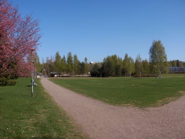
Edellisen kuvan tilanteen jälkeen lämpöaalto vielä voimistui uudestaan niin, että edellisenä päivänä ennen tätä kuvaa päivälämpötila kävi tällä paikalla +22,5 asteessa. Lämpöaallon aiheuttanut korkeapaine oli kuitenkin tässä vaiheessa jo heikentyneenä ja hajanaisena Pohjois-Venäjän, Skandinavian ja pohjoisen Atlantin alueella ja Pohjois-Skandinavian tienoille oli muodostunut pieni matalapaine. Itätuulet pitivät silti vielä yllä vähän tavanomaista lämpimämpää säätä ja ko. päivänä ylin lämpötila oli tällä paikalla +16,8 astetta ja alin +5,3 astetta. Lämmin sää edisti kasvien kasvua edelleen ja edelliseen kuvaan verrattuna vain kahden päivän aikana kehittyneet muutokset näkyvät selvästi; mm. kuvan rusokirsikka (Prunus sargentii) oli nyt jo melkein täydessä kukassa. Koko tämän lämpöaallon aikana pilviä oli hyvin vähän (kuten näissä kahdessa viimeisimmässä kuvassakin) ja yleinen ilmavirtaus oli heikkoa. Se tiesi edelleen vähän alle +10 asteisen Suomenlahden vaikutuksesta selviä iltapäivän merituulitilanteita etelärannikolla. Tämän vaikutuksesta etelärannikon kasvukausi oli nyt jopa muutamia päiviä jäljessä Etelä-Suomen sisämaan tilanteesta; siellä tuomi (Prunus padus) oli paikoin aloittanut kukinnan, mutta ei aivan esim. tällä kuvan alueella. Kasvukausi oli nyt suunnilleen 1 - 2 viikkoa edellä normaalista. Säätilanne: valitse 10.5.2006; Wetter3 A. Wetter3 B.
After the situation of the previous picture the wave of warm weather got stronger again in such a way, that in the previous day before this picture the afternoon temperature was in this area +22,5 C. However the high pressure responsible for this warm weather was now weakened and dispersed over northern Russia, Skandinavia and northern Atlantic and around northern Skandinavia a small low pressure had been formed. Easterly winds maintained further a bit warmer than the average weather though and in this day the maximum temperature was +16,8 C and the minimum +5,3 C. The warm weather helped the growing of the plants further and when compared to the previous picture the changes formed during only two days are showing clearly; for example in this picture Sargent Cherry (Prunus sargentii) was now allmost in full bloom. During this whole wave of warm weather there were very little amount of clouds (as in these latest two pictures as well) and the overall wind condition was calm. That meant clear sea breeze situations during afternoons by the southern coast due to The Gulf Of Finland, which was yet a bit under +10 C. Because of this the growing season was now even a few days late by the southern coast as compared to the situation in the inland areas of southern Finland; there Bird Cherry (Prunus padus) had been started flowering locally but not quite in the area of this photo for example. Approximately the growing season was now ahead about 1 - 2 weeks of the normal stage. Weather condition: choose 10.5.2006; Wetter3 A. Wetter3 B.
Helsingin Puistolan säätilasto toukokuussa 2006 - Weather chart of Puistola, Helsinki in May 2006.
Flickr 1 Flickr 2
Tehoisa lämpösumma - The Effective Temperature Sum: 105,7

posted by Mika at
3:54 PM
![]()


0 Comments:
Post a Comment
<< Home