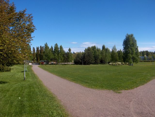
Edelliseen kuvaan verrattuna tässä jatkui samanlainen säätyyppi; iltapäivällä sisämaassa oli sadekuuroja ja yöllä sateiden vähennyttyä oli etenkin sisämaassa monin paikoin hallaa. Viileä ilmamassa vallitsi siis edelleen ja päivälämpötila jäi +16,8 asteeseen. Tässä ja edellisessä kuvassa nähdään lähes selkeää taivasta, mutta itse asiassa molemmissa tilanteissa sisämaan kuuropilvet olivat hyvin lähellä kuvaajan selän takana ja vasemmalla puolella. Merituuli vaikutti sen verran, että meren ylle ei syntynyt kuuropilviä. Tässä kuvassa nähdään parhaiten Virossa olleiden kuuropilvien yläosia meren toisella puolella taivaanrannassa. Tässä vaiheessa etelästä oli lähestymässä uusi voimistuva matalapaine, jonka myötä etelästä meren yli nousi illalla runsasta pilvisyyttä; mm. untuva-, harso-, verho- ja kumpukerrospilviä. Samalla itätuuli voimistui ja seuraavana yönä ei siten ollut enää hallaa; edellinen yö jäi kevään viimeiseksi hallayöksi. Viileästä säästä huolimatta aurinko oli näin tokokuun lopussa niin korkealla, että vallinneessa heikossa tuulessa n. +15 astettakin tuntui miellyttävän lämpimältä. Päivät olivat myös jo niin pitkiä, että yöt eivät enää pimenneet kokonaan toukokuun alun jälkeen ja 30. päivänä aurinko nousi jo heti aamu neljän jälkeen ja laski illalla vasta melkein puoli yhdeltätoista. Selvästi kesän makua oli siis tällä hetkellä ilmassa, vaikka vielä oli melko viileää. Suomenlahden vesi pysyi kuitenkin koko toukokuun ajan korkeintaan vain n. +10 asteessa ja toukokuun alun kesäisen lämpöaallon jälkeen pienet vesistötkään eivät olleet juuri sen lämpimämpiä (lämpöaallossa ehtivät olla kuitenkin lähes +20 astetta). Säätilanne: valitse 31.5.2006; Wetter3 A. Wetter3 B.
As compared to the previous picture here was continuing the same kind of weather type; there were showers in the afternoon in inland areas and at night as the precipitation eased away there was ground frost in many places especially in inland areas. So, the cool air mass continued further and the afternoon temperature stayed at +16,8 C. In this and the previous picture we see allmost clear skies, but actually in the both situations cumulonimbus clouds / shower clouds of the inland areas were near the photographer in the backside and on the leftside. The sea breeze was affecting in such a way, that there weren't cumulonimbus clouds forming over the sea. In this picture we see in the best way the uppersides of the cumulonimbus clouds in Estonia on the other side of the sea on the horizon. At this stage there was a new and strengthening low pressure nearing from the south, which brought plentyfull cloudyness in the evening across the sea from the south; for example cirrus, cirrostratus, altostratus and stratocumulus clouds. An easterly wind picked up at the same time and therefore there wasn't ground frost anymore at the next night; the previous night remained the last night with ground frost this spring. Despite the cool weather the sun was so high at this time of may, that in the prevailed weak wind even about +15 C felt pleasently warm. The days were also so long, that nights didn't darkened completely anymore since the beginning of may and at the 30th day the sun rose allready immediately after 4 am and it was setting as late as allmost half past ten in the evening. So, there was clearly summery feel in the air at this time, allthough it was yet rather cool. However the water of The Gulf Of Finland stayed at highest only about +10 C during all may and after the summery warm weather period in early may small waters weren't much that warmer either (however they had time to be allmost +20 C in the warm period) Weather condition: choose 31.5.2006; Wetter3 A. Wetter3 B.
Helsingin Puistolan säätilasto toukokuussa 2006 - Weather chart of Puistola, Helsinki in May 2006.
Flickr 1 Flickr 2
Tehoisa lämpösumma - The Effective Temperature Sum: 194,4

posted by Mika at
3:32 PM
![]()


0 Comments:
Post a Comment
<< Home