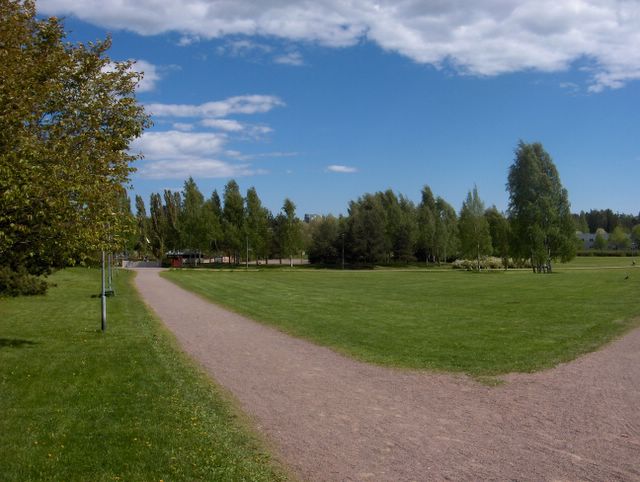
Määritelmän mukaan kesä alkaa eteläisessä Suomessa, kun vuorokauden keskilämpötila kohoaa pysyvästi yli +10 asteen. Näin käy yleensä vähän toukokuun puolenvälin jälkeen. Tänä vuonna kesä yritti alkaa poikkeuksellisen aikaisin toukokuun alussa helleaallon takia, mutta sittemmin viileän sään takia tuo em. raja-arvo juuri ja juuri ylittyi pysyvämmin vasta toukokuun 30. päivästä lähtien. Edellisen kuvan jälkeen etelästä nousi voimakas, mutta pieni matalapaine. Se liikkui Suomen itärajaa viistäen pohjoiseen ja siihen liittynyt sadealue jäi hyvin täpärästi tulematta tälle seurantapaikalle; vähän idempänä satoi melko runsaasti. Edellisenä päivänä pohjoistuuli oli kuitenkin voimakasta ja sää runsaspilvistä. Kuvauspäivänä tuulet heikkenivät vähän ja kääntyivät länteen uuden matalapaineen lähestyttyä lännestä Lappia. Heikon korkeapaineen selänteen ansiosta kuvaustilanteessa vallitsivat vain kumpupilvet ja niistä syntyneet kumpukerrospilvet. Ne etenivät tuulen mukana melko lähelle merta (kuten kuvasta nähdään); yleinen ilmavirtaus kumosi siis vähän merituulta. Samasta syystä myös rannikolla oli tavanomaisen lämmintä sisämaan tapaan; ko. päivänä ylin lukema oli +19,4 astetta. Tuulen ja pilvien vuoksi öisin oli kohtuullisen lämmintä. Kasvukausi oli edennyt edelleen tavanomaisessa aikataulussa ja se nähtiin mm. tuon kuvan vasemman laidan rusokirsikan (Prunus sargentii) lähes kadonneesta kevätväristä. Nurmikko oli jälleen leikattu ja sen vihreys oli tyypillisen voimakasta tässä vaiheessa. Säätilanne: valitse 2.6.2006; Wetter3 A. Wetter3 B.
According to the definition summer starts in southern Finland, when the daily average temperature rises permanently above +10 C. That happens usually a little after mid may. This year summer tried to start unusually early at early may due to the heatwave, but since then because of the cool weather that limit was barely topped more permanently only from the 30th of may onwards. After the previous photo a strong, but small low pressure came from the south. It moved along the eastern border of Finland to the north and the precipitation area associated with it missed narrowly this observation post; a little more eastwards it rained rather plentyfully. However during the previous day northerly winds were strong and the clouds appeared plentyfully. During the photoshooting day the winds eased a bit and they turned to the west as a new low pressure approached Lapland from the west. Due to a weak ridge of high pressure there prevailed only cumulus clouds and stratocumulus clouds born from them. They proceeded rather near the sea (as we can see from the photo) with the wind; in other words the general airflow overruled a little the sea breeze. Due to the same reason by the coast there was typically warm in the way of the inland areas; during this day the maximum temperature was +19,4 C. Due to the clouds and winds there were moderately warm also at nights. The growing season had been progressed further according to an average time table and it was observed for example from the allmost disappeared spring colour of Sargent Cherry (Prunus sargentii) on the left side of the picture. The lawn had been mowed again and the green tone of it was typically strong at this stage. Weather condition: choose 2.6.2006; Wetter3 A. Wetter3 B.
Helsingin Puistolan säätilasto kesäkuussa 2006 - Weather chart of Puistola, Helsinki in June 2006.
Flickr 1 Flickr 2
Tehoisa lämpösumma - The Effective Temperature Sum: 211,1

posted by Mika at
2:51 PM
![]()


0 Comments:
Post a Comment
<< Home