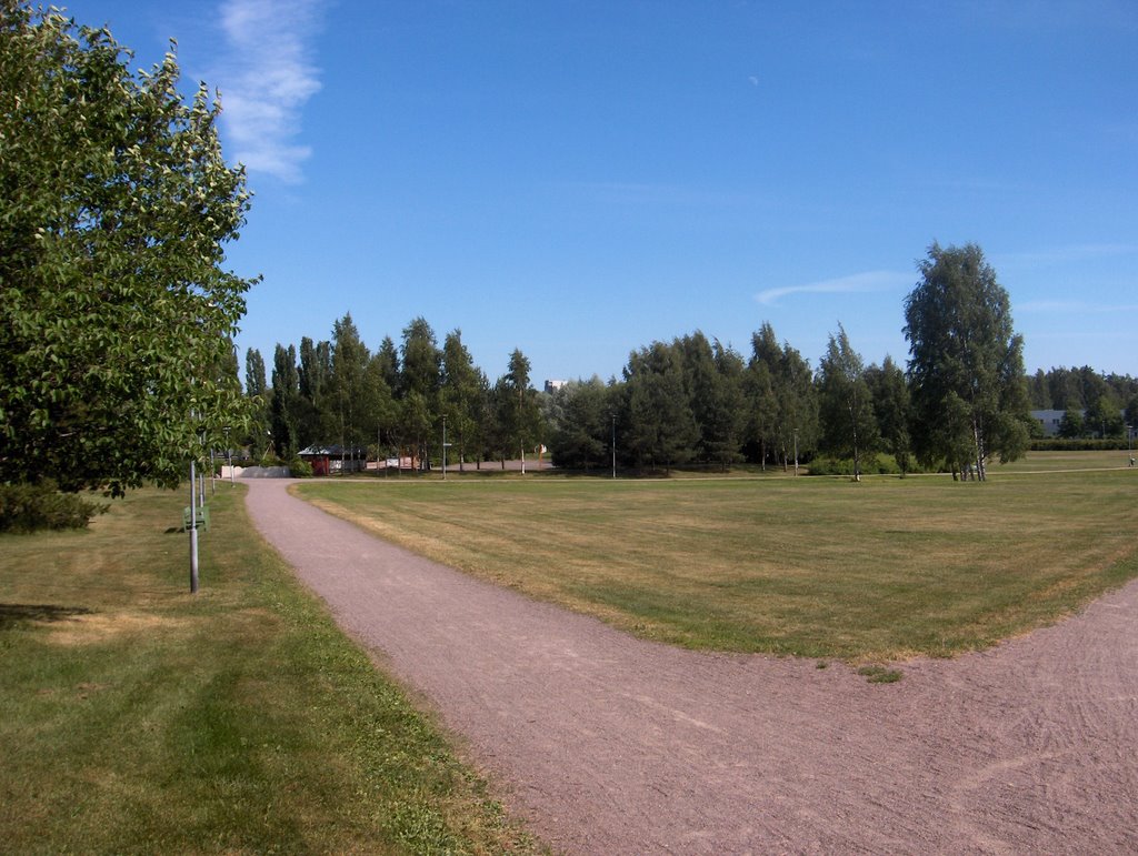
Edellisen kuvan jälkeen Etelä-Suomen yllä ollut pieni matalapaine siirtyi nopeasti itään heti seuraavana päivänä ja korkeapaine alkoi vaikuttamaan lännestä käsin. Sitten korkeapaine siirtyi eteläisen Suomen ylle ja jäi suunnilleen sijoilleen tähän päivään asti. Korkeapaine toi mukanaan kesän neljännen helleaallon (hellealue ulottui Espanjaan asti), jossa ko. päivänä mitattiin heinäkuun tähän mennessä korkeimmat lukemat; ko. paikalla +26,6 astetta ja sisämaassa lähes +30 astetta. Korkeapaineen takia tuulet olivat 30.6. lähtien yleisesti hyvin heikkoja ja tyyniäkin, mutta merituuli vaikutti ajoittain ja alensi siten tilapäisesti esim. tällä alueella tämän kuun 1. päivän ylintä lämpötilaa. Lämmennyt Suomenlahti (rantavesien lämpötilat olivat n. +20 astetta) ja yli +20 asteen lämmenneet pienetkin järvet vaikuttivat toisaalta yölämpötiloihin kohottamalla niitä muutamalla asteella paikallisesti ja ajallisesti vaihdellen. Ilmamassa oli koko ajan melko kuivaa (taivaan voimakas sinisyys) ja kumpupilvien muodostuminen oli siten hyvin vähäistä eteläisessä Suomessa. Korkeapaineen itäpuolella Venäjälle virtasi hyvin viileää ilmaa pohjoisesta ja Suomen itärajan lähellä ko. ilmamassaa rajasi vaihteleva rintamasysteemi. Sen pilvisyyttä esiintyi ajoittain kuvan tapaan untuvapilvinä Etelä-Suomessa. Ajoittain oli myös harso-, verho- ja hahtuvapilviäkin, mutta vain vähän; ne vaikuttivat silti esim. kohottamalla yölämpötiloja paikallisesti. Sateettoman ja kuuman sään vuoksi kuivuus paheni entisestään ja kuvan nurmikolle se tiesi tässä vaiheessa kasvun tyrehtymistä jo kokonaan ja värin muuttumista melkein kokonaan ruskeaksi. Myös kivikkoisten mäkien lehtipuut ja -pensaat muuttuivat paikoin hyvin näkyvästi keltaisiksi kuin syksyllä. Kosteilla alueilla kasvukausi eteni silti vielä nopeasti ja etumatka tavanomaiseen aikatauluun oli jo n. kaksi viikkoa. Tämän vuoksi heinäkuun tyypillinen kukkija maitohorsma (Epilobium angustifolium) oli jo nyt keskimäärin täydessä kukassa. Säätilanne: valitse 3.7.2006; Wetter3 A. Wetter3 B.
After the previous photo the lowpressure over southern Finland moved quickly to the east immediately the next day and a high pressure started to affect from the west. Then the high pressure moved over southern Finland and remained approximately in place until this day. The high pressure brought the fourth heatwave (the hot area reached all the way to Spain) of the summer with it, where during this day there was measured the highest readings of july so far; in this area +26,6 C and in inland areas allmost +30 C. Due to the high pressure the winds were commonly very weak and also calm from 30th of june onwards, but the sea breeze affected occasionally and it lowered down temporarily for example in this area the maximum temperature of the 1st day of this month. The warmed up The Gulf Of Finland (Temperatures of coastal waters were about +20 C) and also small lakes warmed up over +20 C had an effect on the other had to the night temperatures as rising the readings couple of degrees varying locally and temporally. The air mass was all the time rather dry (strong blueness of the sky) and therefore the formation of cumulus clouds was very minor in southern Finland. In the eastern side of the high pressure there flowed very cool air into Russia from the north. Near the eastern border of Finland this air mass was bordered by a variable frontal zone. Its cloudyness appeared occasionally as cirrus clouds in southern Finland in the way of the picture. Occasionally there were also cirrostratus, altostratus and even altocumulus clouds, but only small amounts; they affected though as rising up the night temperatures locally. Due to the rainless and hot weather the drought worsened further and it meant at this stage to the lawn in the picture a suffocation of the growth allready completely and a change of colour into allmost completely brown. Also the broadleave trees and shrubs in rocky hills turned locally very visibly yellow like in autumn. In moist areas though the growing season progressed yet fast and the advance to the average time table was now allready about two weeks. Therefore typical bloomer of July Fireweed (Epilobium angustifolium) was allready now approximately in full bloom. Weather condition: choose 3.7.2006; Wetter3 A. Wetter3 B.
Helsingin Puistolan säätilasto heinäkuussa 2006 - Weather chart of Puistola, Helsinki in July 2006.
Flickr 1 Flickr 2
Tehoisa lämpösumma - The Effective Temperature Sum: 568,7
posted by Mika at
4:00 PM
![]()


0 Comments:
Post a Comment
<< Home