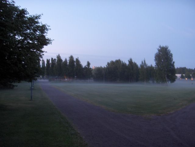
Edellisen kuvan jälkeen kesäsää oli palannut tässä vaiheessa lämpötilojen suhteen tavanomaiselle tasolle. Edellisenä päivänä ylin lämpötila oli +19,7 astetta ja kuvan tilanteessa yölämpötila oli alimmillaan +11,6 astetta. Tämän aiheutti Norjan länsireunalta Skandinavian pohjoispuolelle liikkunut matalapaine, joka toi lännestä heikon - kohtalaisen tuulen mukana viileämpää ilmaa. Hyvin lähelle Suomen itäpuolelle jäi kuitenkin erittäin helteistä ilmamassaa paikalleen; päivälämpötilat olivat siellä jopa +30 - +35 astetta. Suomen viileämmän ja idän kuuman ilman rajalla oli edelleen rintama voimakkainekin ukkosineen ja kuvassa ko. rintaman takapuolen untuvapilvisyyttä nähdään kaukana taivaanrannassa heikosti näkyvänä vyöhykkeenä. Tämä kuva on otettu siis yöllä ja tästä nähdään, kuinka valoisaa tähän aikaan vuodesta eteläisessä Suomessa on; kesäpäivänseisaus oli 21. päivänä. Keskiyön aurinko paistaa kuitenkin vain Napapiirin pohjoispuolella. Ko. alkanut päivä oli Juhannuspäivä. Kuvassa nähdään myös tyypillinen aamuyön sumu- / usvatilanne. Vallinneessa tyynessä säässä syntyy helposti ns. säteilysumua, jos ilman kosteus on riittävää. Kosteutta oli nyt maassa vähän enemmän kuin aikaisemmin em. rintaman sateiden ylitettyä ko. paikan edellisenä yönä. Kosteus jäi kuitenkin pinnalliseksi ja sateiden kuuroluonteen vuoksi paikalliseksikin ja siten kuivuus ei loppunut kokonaan. Kuivuudesta oli haittaa tähän mennessä silti lähinnä vain ruohovartisille kasveille. Säätilanne: valitse 24.6.2006; Wetter3 A. Wetter3 B.
After the previous picture summer weather had been returned to the average level at this stage considering the temperatures. In the previous day the maximum temperature was +19,7 C and in the situation of the picture the night temperature was +11,6 C at the lowest. That was caused by the low pressure moved from the western edge of Norway to the northern side of Skandinavia. It brought cooler air from the west along weak - moderate winds. However very near in the eastern side of Finland there remained very hot air mass in place; the afternoon temperatures were there even between +30 C and +35 C. Between the cooler air and the hot air of the east there was further a front with its also severe tunderstorms and in the photo we see the backside cirrus cloudyness of that front far away in the horizon as a faintly visible belt. So this photo is taken in the night and we can see from this, how light there is in southern Finland at this time of the year; the summer solstice was at the 21st day. However the midnight sun is shining only north from the Arctic Circle. The started day in question was Mid Summer's Day (a biggest celebration in summer in Finland). In the picture we see also a typical early morning fog / mist situation. In the prevailed calm weather so called radiation fog forms easily, if there's enough air moisture available. There was now moisture in the ground a little more than before as the precipitation of the mentioned front crossed this scene during the previous night. However the moisture remained superficial and also local due to the showery nature of the precipitation and therefore the drought didn't stop completely. The drought caused harm mainly to the herbacious plants only up to this moment though. Weather condition: choose 24.6.2006; Wetter3 A. Wetter3 B.
Helsingin Puistolan säätilasto kesäkuussa 2006 - Weather chart of Puistola, Helsinki in June 2006.
Flickr 1 Flickr 2
Tehoisa lämpösumma - The Effective Temperature Sum: 455,7

posted by Mika at
2:53 AM
![]()


0 Comments:
Post a Comment
<< Home