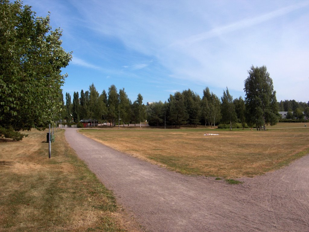
Edellisen kuvan jälkeen Euroopassa vallitsi yhä ilmanpainekenttä hyvin pienine ilmanpaine-eroineen ja vain Atlantilla sekä Pohjois-Venäjällä oli kunnon matalapaineet. Länsi- ja Keski-Euroopan helteisen ilmamassan pienet matalapaineet eivät olleet kuitenkaan vähäpätöisiä, sillä tyypillisesti niiden alueilla esiintyi paikoin ankaria ukkosia. Suomeen ja tähän tarkastelupaikkaan liittyen Etelä-Suomen ylle jäi aluksi edellisen tilanteen rintama ja eteläisin Suomi kuului kesän kuudennen (17.7. ei laskettu mukaan) helleilman piiriin; ylin lukema +27,2 astetta oli 25. päivänä. Tällöin tuli edelleen paikoin sade- ja ukkoskuuroja 25. päivän iltapäivällä, mutta lähinnä vain sisämaassa ja kuvauspaikalla ei yhtään. Kahtena edellisenä päivänä Suomen länsipuolella oli korkeapaine ja vähän voimistuneessa pohjoistuulessa ilmamassa kuivui ja viileni (ylin lukema oli edellisenä päivänä +21,5 astetta). Siinä vallitsivat lähinnä vain hyvin vähäiset iltapäivän kumpupilvet. Kuvauspäivänä em. korkeapaine oli jakautumassa kahtia ja Etelä-Skandinaviaan muodostunut matalapaine alkoi liikkua siitä välistä Suomen eteläpuolelle. Kuvassa nähdään matalapaineeseen liittyneen lämpimän rintaman untuvapilviä eteläisillä taivaalla rintaman suuntaisena kilpenä. Muita pilvilajeja ei tilanteessa ollut. Rintaman eteläpuolelle jäi Euroopassa edelleen vaikuttanut hyvin helteinen ilmamassa, joka ulottui lähimmillään Etelä-Ruotsiin. Rintaman sateet eivät ulottuneet paikalle, joten kuivuus eteni edelleen ja nyt se näkyi jo tämän alueen puissa. Kuvassa keskeltä vähän vasemmalle nähdään rauduskoivujen (Betula pendula) lehtien kellastuneen, vaikka normaalisti tämä kasvupaikka on hyvin kostea; pohjavesi on korkealla ja maalaji on melko savinen. Tämä kuvasti kuivuuden merkittävää erikoisuutta. Tässä vaiheessa kuivuus edesauttoi jo metsäpalojen syntymistäkin niin Suomessa kuin lähialueilla. Säätilanne: valitse 28.7.2006; Wetter3 A. Wetter3 B.
After the previous picture there prevailed further an air pressure field in Europe, where there were small air pressure differences and only in Atlantic and Russia there were proper low pressures. However small low pressures in the hot air mass in western and middle Europe weren't insignificant as in their areas there appeared locally severe thunder in a typical way. Concerning Finland and this observation post the front of the previous situation remained at first over southern Finland and the southernmost Finland belonged in the sixth hot air mass of the summer (17th of July not counted for); the highest reading was +27,2 C at the 25th day. At that time there came further local showers and thunder during the 25th day's afternoon, but mainly in inland areas and not a single one in this place. During the previous two days there was a high pressure in the western side of Finland and in a little strengthened northerly wind the air mass got cooler and drier (the maximum reading in the previous day was +21,5 C). In there prevailed only minor cumulus clouds of the afternoon. In the photoshooting day the mentioned high pressure was dividing into half and a low pressure formed in southern Skandinavia started to move southern side of Finland between there. In the picture in the southern horizon we see cirrus clouds in the form of a shield according to the direction of a warm front associated with the low pressure. There weren't other cloud types present in the situation. The hot air mass further affected Europe was left southern side of that front. The hot air reached southern Sweden at the closest. The precipitaiton of that front didn't reach the area and so the drought progressed further and now it was showing allready in the trees of this scene. In the picture a little left of the middle we see the leaves of Silver Birches (Betula pendula) turned a bit yellow, allthough normally this locality is very moist; the ground water is high and the soil type is rather clayish. This was presenting the significant peculiarity of the drought. At this stage the drought was allready helping the formation of forest fires as well both in Finland and nearby areas. Weather condition: choose 28.7.2006; Wetter3 A. Wetter3 B.
Helsingin Puistolan säätilasto heinäkuussa 2006 - Weather chart of Puistola, Helsinki in July 2006.
Flickr 1 Flickr 2
Tehoisa lämpösumma - The Effective Temperature Sum: 935
posted by Mika at
4:01 PM
![]()


0 Comments:
Post a Comment
<< Home