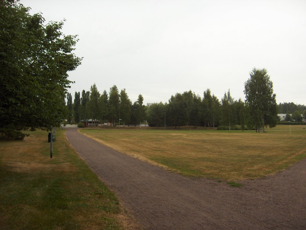
Kuvan tilanteessa satoi vihdoin vettä tälle paikalle, mutta vain heikosti ja vähän aikaa; taivaalla oli sade-, kumpukerros- ja sumupilviä. Sisämaassa satoi paikoin runsaammin ja myös ukkosti. Ennen tätä sadetta kuun 18. päivänä lähellä tätä paikkaa liikkui sateita lännestä Suomen ylle muotoutuneen matalapaineen alueella. Sateet voimistuivat kuitenkin vasta idemmäksi mentyään, kun matalapaineen rintamat kohtasivat Venäjällä säilyneen helteisen ilmamassan. Niinpä lähinnä Itä-Suomessa tuli kuurottaisia sateita. Tämän jälkeen Islannin ja Norjan välistä Välimerelle ulottui korkeapaine ja Suomi jäi itään ja koilliseen siirtyneen matalapaineen länsipuoliselle pohjoistuulen alueelle, jossa vallitsivat lähinnä iltapäivän kumpupilvet. Sää siis viileni; ylimmät lukemat olivat vain n. +20 astetta ja yölämpötilat etenkin sisämaassa vähän alle +10 astetta. Kuun 20. päiväksi ko. korkeapaine siirtyi Suomen ylle ja tuuli tyyntyi. Korkeapaineen länsi - lounaispuolella oli vallinnut jo muutaman päivän ajan erittäin kuuma ilmamassa Länsi-Euroopassa, jossa ilmanpaine-erot olivat tyypillisesti erittäin pieniä. Esim. Saksan ja Puolan tienoilla oli 20. päivänä jopa +35 - +40 asteen helteitä. Edelliseksi päiväksi tuon helleilman pohjoisrajalle syntyi Etelä-Skandinaviaan pieni matalapaine, joka toi vähän kuurottaisia (paikoin ukkostakin) sateita lounaiseen Suomeen jo silloin. Helleilma ei kuitenkaan päässyt Suomeen. Kuivuus ei juurikaan helpottanut ja kuvassa oleva nurmikko ei siis jatkanut kasvuaan. Ainoat vähän vihreät kohdat siinä olivat mm. voikukkia (Taraxacum officinale), piharatamoita (Plantago major) ja rönsyleinikkejä (Ranunculus reptans), jotka sietävät paljon kuivuutta. Kosteilla alueilla kasvukauden etumatka tavanomaiseen näkyi mm. maitohorsman (Epilobium angustifolium) kukinnan loppumisena ja hedelmien aikaisina kypsymisinä; mm. terttuseljan (Sambucus racemosa), tuomen (Prunus padus) ja mustikan (Vaccinium myrtillus) marjat paikoin jo ennen kuun puoltaväliä. Mustikka kuitenkin kärsi monin paikoin kuivuudesta ja joillakin alueilla kasvustot olivat kuivuneet ruskeiksi ja marjasatoa ei muodostunut ollenkaan. Säätilanne: valitse 22.7.2006; Wetter3 A. Wetter3 B.
In the situation of the photo it finally rained in this place, but only weakly and for a short time; there were nimbostratus, stratocumulus and stratus clouds in the sky. In inland areas there rained locally more and there were also thunder. Before this rain at the 18th day of the month near this place there was precipitation moving about in the area of a low pressure arrived from the west over Finland. However the precipitation got stronger after it moved more eastwards, as the fronts of the low pressure met the hot air that remained over Russia. Therefore there came showery rain mainly in eastern Finland. After that there reached a high pressure from between Iceland and Norway towards Mediterranean sea and as the low pressure moved to the east and northeast Finland stayed in the area of northerly winds, where prevailed mainly cumulus clouds of the afternoon. So the weather got cooler; the maximum temperatures were only about +20 C and the night temperatures especially in inland areas a little less than +10 C. The high pressure moved over Finland until the 20th day and the wind calmed down. In the western and southwestern side of the high pressure there had been prevailed allready for couple of days a very hot air mass in western Europe, where the air pressure differences were typically very small. For example around Germany and Poland there were hot temperatures even between +35 C and +40 C at the 20th day. Until the previous day at the northern limit of that hot air mass a small low pressure was produced in southern Skandinavia, which brought a little showery rain (locally also thunder) into southwestern Finland allready then. However the hot air didn't arrive in Finland. The drought hardly eased and so the lawn in the picture didn't continue growing. The only little green spots in there were for example Dandelions (Taraxacum officinale), Common Plantains (Plantago major) and Creeping Spearworts (Ranunculus reptans), which can tolerate a lot of drought. In moist areas the advance of the growing season compared to the average was showing for example as ending of the Fireweed (Epilobium angustifolium) blooming and as early ripening of fruits; for example berries of Red Elderberry (Sambucus racemosa), Bird Cherry (Prunus padus) and Blueberry (Vaccinium myrtillus) locally before the middle of the month allready. However Blueberry was harmed in many places by the drought and in some areas its growth had been dried brown and there wasn't formed berry crop at all. Weather condition: choose 22.7.2006; Wetter3 A. Wetter3 B.
Helsingin Puistolan säätilasto heinäkuussa 2006 - Weather chart of Puistola, Helsinki in July 2006.
Flickr 1 Flickr 2
Tehoisa lämpösumma - The Effective Temperature Sum: 851,2
posted by Mika at
11:44 AM
![]()


0 Comments:
Post a Comment
<< Home