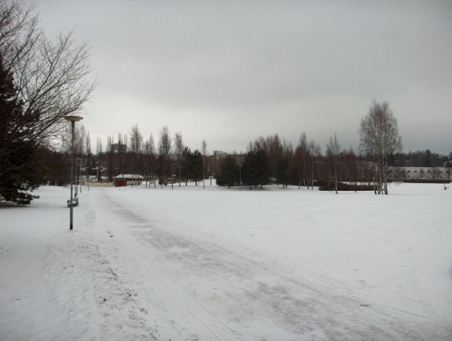
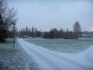
Korkeapaineen vaikutuspiirissä olleiden kaakkois- ja itätuulten sekä kohtalaisen pakkasen jälkeen tuulet kääntyivät kuvauspäivänä etelään ja sää lauhtui jälleen. Tässä vaiheessa Etelä-Skandinaviaan etelästä nousseen matalapaineen mukana tuli säärintama heikkoine lumisateineen. Kuvassa vallitsivat kuitenkin lähinnä rintaman jälkeiset sumupilvet ja lämpötila kohosi iltaan mennessä -3,4 asteesta +0,2 asteeseen. Kahtena aikaisempana päivänä olleet voimakkaat kaakkoistuulet nietostivat pakkaslunta kuvan puistokäytävällä nähtävään tyyliin. Säätilanne: valitse 30.12.2005; Wetter3 A. Wetter3 B.
After east and southeasterly winds and moderately frosty weather in the range of a high pressure the winds were turning to south during the photoshooting day and it was getting milder again. At this phase a weather front and weak snowing associated with it came along with a low pressure moving from the south to southern Skandinavia. However in the picture stratus clouds were dominant after the front and the temperature rose from -3,4 C to +0,2 C until the evening. During the two previous days strong southeasterly winds drifted the dry frosty snow like seen on the path in the picture. Weather condition: choose 30.12.2005; Wetter3 A. Wetter3 B.Helsingin Puistolan säätilasto joulukuussa 2005 - Weather chart of Puistola, Helsinki in December 2005.Flickr 1 Flickr 2 
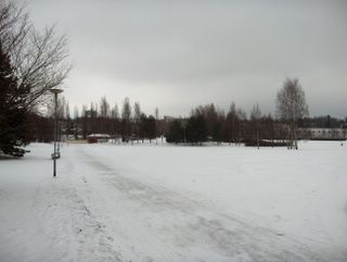
Jouluaatosta Tapaninpäivään asti lännestä saapunut matalapaine toi lumisateen ja talven ensimmäisen pitkäaikaisen lumipeitteen (Etelä-Suomen sisämaassa lunta oli jäljellä muutamia senttejä koko joulukuun ajan) etelärannikolle ja siten myös tälle havaintopisteelle. Kuvanottohetkelläkin satoin vielä lunta heikosti. Lämpötila käväisi suojan puolella 23. - 24.12., mutta sen jälkeen pakkanen oli kohtalaista kaakkois- ja itätuulten ansiosta. Niinpä valkoinen joulu oli taattu tällä kertaa. Kuvauspäivänä oli pakkasta -8,2 ... -2,3 astetta ja korkeapaine oli vahvistumassa Pohjois-Suomeen matalapaineen vetäytyessä etelään. Pilvityyppeinä kuvassa olivat sumupilvi ja sadepilvi. Pakkassäällä ne muistuttavat toisiaan suuresti. Säätilanne: valitse 26.12.2005; Wetter3 A. Wetter3 B.
From Christmas Eve to Boxing Day southern coast (in inland areas of southern Finland there was snow left for a few centimetres during all december) and therefore also this observation post got snowing and the first long lasting snowcover of the winter brought by the low pressure from the west. It was still snowing slightly also when this picture was taken. The temperature was temporarily above freezing point at 23th and 24th of December, but after that moderately strong frost was dominant due to southeasterly and easterly winds. Therefore the white Christmas was quaranteed this time around. The temperature was between -8,2 C and -2,3 C during the photoshooting day and a high pressure was strengthening over northern Finland as the low pressure was retreating to south. The cloud types in the photo were stratus and nimbostratus clouds. In a frosty weather they resemble each other greatly. Weather condition: choose 26.12.2005; Wetter3 A. Wetter3 B.Helsingin Puistolan säätilasto joulukuussa 2005 - Weather chart of Puistola, Helsinki in December 2005.Flickr 1 Flickr 2
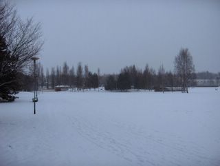
 Kuvassa oleva lumipeite oli lähes muuttumaton edelliseen kuvaan nähden lähes sateettomasta säästä johtuen. Ihmisten jäljet hangessa tosin lisääntyivät. Näiden kuvien välillä oli talven tähän mennessä kylmin pakkasjakso, jolloin maa jäätyi useita senttejä syvemmälle. Kuvan tilanteessa vallitsi heikko tuuli, mutta lähestyvän heikon sadealueen pilvet (verhopilvet) peittivät jo taivaan. Sadealue liittyi lännestä lähestyneen matalapaineen edellä olleeseen okluusiorintamaan. Ilma lämpeni yön -14,1 asteesta +0,2 asteeseen päivän loppuun mennessä voimakkaan lounaistuulen myötä. Säätilanne: valitse 23.12.2005; Wetter3 A. Wetter3 B. The snowcover in the picture was allmost unchanged as compared to the previous picture due to a very little amount of precipitation. Tracks in the snow made by people increased though. Between those pictures there were the coldest frosty period so far this winter, that caused the soil to freeze several centimetres deeper. In the captured situation winds were weak, but clouds (altostratus) of an incoming and weak precipitation area covered allready the sky. The precipitation area was associated with a occluded front before a low pressure, that was nearing from the west. The temperature rose from nightly -14,1 C to +0,2 C by the end of the day due to a strong southwesterly wind. Weather condition: choose 23.12.2005. Wetter3 A. Wetter3 B.Helsingin Puistolan säätilasto joulukuussa 2005 - Weather chart of Puistola, Helsinki in December 2005.Flickr 1 Flickr 2
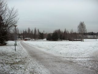
 Kuvan tilanteessa satoi hyvin heikosti lunta, jota oli kertynyt kuvassa nähtävä määrä edellisestä päivästä lähtien. Ilman lämpötila vaihteli -9,1 ja +0,6 asteen välillä siten, että päivän aikana sää kylmeni koko ajan koillisesta virranneen ilmamassan takia. Tuulet olivat kuitenkin heikkoja, sillä eteläisen Suomen yllä oli laajan matalapaineen keskus. Sen siirryttyä kylmä ilma pääsi myös kuvauspaikalle. Pilvinä kuvassa olivat sumu- ja sadepilvet. Maa oli yhä edelleen muutamia senttejä jäässä huolimatta 10. - 16.12. vallinneesta leudommasta sääjaksosta; lähes koko ajan suojaa. Säätilanne: valitse 16.12.2005; Wetter3 A. Wetter3 B.In the situation of the picture it was snowing very slightly. As seen in the picture the snowcover was formed from the day before onwards. The temperature changed between -9,1 C and +0,6 C during the day in the way that it was getting colder all the time due to a air mass flown from the northeast. The winds were were weak though, because the center of a wide low pressure was over southern Finland. When it moved the colder air streamed also to the photoshooting scene. The clouds in the picture were stratus and nimbostratus clouds. The soil was still frozen for a few centimetres despite a milder weather period between 10th and 16th of December; allmost all the time thaw. Weather condition: choose 16.12.2005; Wetter3 A. Wetter3 B.Helsingin Puistolan säätilasto joulukuussa 2005 - Weather chart of Puistola, Helsinki in December 2005.Flickr 1 Flickr 2
 Kuvan tilanteessa vallitsi heikko länsiluoteinen tuuli ja taivas oli tilapäisesti selkeä. Ilman lämpötila oli ko. vuorokauden aikana -8,1 ja -0,2 asteen välillä siten, että sää lauhtui illan loppuun mennessä. Suomea oli ylittämässä lännestä heikko korkeapaineen selänne. Aikaisemmasta joulukuun leudosta ja lähes sateettomasta säästä johtuen lunta ei juuri ollut, mutta maa oli jo jäätynyt muutamia senttejä kuvauspäivään päättyneen lyhyen pakkasjakson takia. Säätilanne: valitse 10.12.2005; Wetter3 A. Wetter3 B.In the captured situation there were a weak west-northwesterly wind and it was temporarily clear. The temperature was between -8,1 C and -0,2 C during the day in a way, that it got milder by the end of the evening. A weak ridge of high pressure was crossing Finland from the west. The previous mild and allmost dry weather in December meant that there was allmost no snow on the ground, but the soil was allready frozen for a few centimetres due to a short frosty period that ended until this day of the photoshoot. Weather condition: choose 10.12.2005; Wetter3 A. Wetter3 B.Helsingin Puistolan säätilasto joulukuussa 2005 - Weather chart of Puistola, Helsinki in December 2005.Flickr 1 Flickr 2