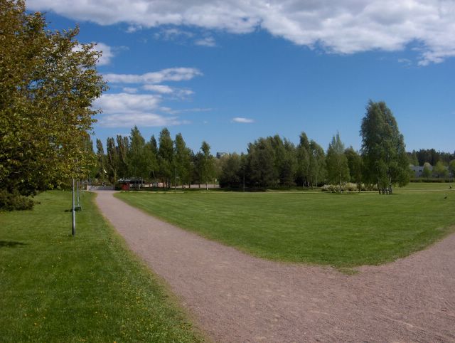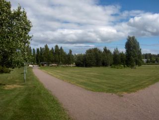
Tämä kuva on otettu myöhemmin iltapäivällä verrattuna saman päivän aamuna otettuun edelliseen kuvaan. Ko. tilanteessa Etelä-Suomen ylle jäänyt pieni matalapaine oli tässä vaiheessa muotoutunut sen verran, että nyt kuvauspaikalla oli alkanut vaikuttamaan viileä polaarinen länsivirtaus ja tuuli oli siten voimistunut; kuten kuvan vasemassa laidassa olevasta rusokirsikasta (Prunus sargentii) havaitaan. Merituulesta ei nyt ollut kyse. Tämän ilmamassan saapuminen tiesi myös kirkkaampaa ilmaa; utu kaikkosi ja taivaan sinisyys alkoi näkyä voimakkaasti. Iltapäivän aikana Etelä-Suomen sisämaa-alueilla esiintyi edelleen kuurosateita etenkin siellä olleen okluusiorintaman kohdalla, mutta etelärannikko poutaantui tässä vaiheessa. Taivaalla olivat kuvan tapaan lähinnä matalat kumpukerrospilvet ja kumpupilvet. Jo edellisenä päivänä sadealueen vuoksi päivälämpötila jäi vähän alle +20 asteen, mutta yölämpötila oli samasta syystä korkeampi (+12,9 astetta) kuin edellisenä yönä ja siihen vaikutti silloin myös Suomen etelä- ja kaakkoispuolella pistäytynyt helteinen ilmamassa. Tämän päivän ylin lämpötila oli viileän ilmamassan takia vain +18,4 astetta, vaikka pilvisyys oli edellistä päivää vähäisempää. Sateiden ansiosta kuvan nurmikko toipui hieman aikaisempaa vihreämmäksi, mutta sateiden riittämättömyyden vuoksi kuivuus eteni silti koko ajan ja se ilmeni nyt mm. pohjavesien hitaana vähentymisenä ja puiden ja pensaiden lehtien kellastumisena ja nuutumisena kuivilla kasvupaikoilla, kuten kallioisilla mäillä. Säätilanne: valitse 28.6.2006; Wetter3 A. Wetter3 B.This picture is taken later in the afternoon as compared to the previous photo taken in the same day's morning. In this situation the small low pressure remained over southern Finland had been transformed in such a way, that now there had been started to affect a cool and polaric westerly air flow in the photoshooting scene and so the wind had been picked up; as we see from Sargent Cherry (Prunus sargentii) in the leftside of the picture. The sea breeze wasn't now in question. The arrival of this air mass meant also clearer air; haze vanished and the blueness of the sky started to appear strongly. During the afternoon there came further showers in the inland areas of southern Finland especially in the place of the occluded front over there, but southern coast became at this stage rainless. In the sky there were in the way of the picture mainly flat stratocumulus and cumulus clouds. Allready in the previous day the afternoon temperature stayed a bit under +20 C due to the precipitation area, but the night temperature was higher (+12,9 C) than in the previous night according to the same reason and the hot airmass briefly visited in the southeastern side of Finland had also an effect on that at that moment. The maximum temperature of this day was only +18,4 C due to the cool air mass, allthough the amount of cloudyness was smaller than in the previous day. Thanks to the rains the lawn in the picture recovered a little greener than before, but due to the inadequate precipitations the drought progressed all the time further though and it was being shown now for example as a slow decreasing of groundwaters and turning yellow and withering of leaves on trees and shrubs in dry localitys as in rocky hills. Weather condition: choose 28.6.2006; Wetter3 A. Wetter3 B.Helsingin Puistolan säätilasto kesäkuussa 2006 - Weather chart of Puistola, Helsinki in June 2006.Flickr 1 Flickr 2Tehoisa lämpösumma - The Effective Temperature Sum: 500,7 
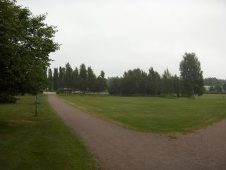
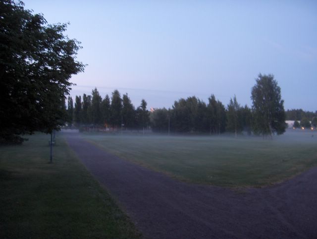
Pienialaisia matala- ja korkeapaineita pienine ilmanpaine-eroineen oli Euroopan ilmanpainekentän tilanne myös tässä vaiheessa. Voimakkain matalapaine oli kehittymässä jo edellisen kuvan tilanteessa Länsi-Euroopassa ja nyt ko. matalapaine oli saapunut Etelä-Suomen ylle lounaasta. Sen mukana Suomen kaakkoispuolelle tuli lounaasta helteistä ilmaa, mutta se ei aivan päässyt Suomeen. Jo edellisenä päivänä ko. matalapaineen säärintamat olivat Etelä-Suomen yllä ja ko. päivänä okluusiorintama jäi suunnilleen samoille sijoille. Tämä tiesi edelliseksi ja täksi päiväksi sateita, jotka olivat kesälle tyypilliseen tapaan kuurottaisia ja vaihtelevasti paikallisia. Kunnollisia ukkosia ei tässä tilanteessa syntynyt etenkään etelärannikolle. Kesäsäähän kuuluu myös se, että kaikilla sateilla on taipumus heikentyä öiksi ja olla voimakkaimmillaan iltapäivisin. Näin oli tilanne myös tällä kertaa. Tämä kuva on yllä olevan saman päivän kuvaparista aamun tilannetta esittävä. Siinä em. okluusiorintaman jälkipuolella vallitsi tyyni ja sumupilvinen sää. Ilmassa oli myös kosteutta äskettäisten sateiden jäljiltä ja etelästä pistäytyneen kostean ja lämpimän ilmamassan takia. Tällöin tyynessä säässä ilmaan muodostui helposti utua ja vähän sumuakin. Säätilanne: valitse 28.6.2006; Wetter3 A. Wetter3 B.Small low and high pressures with small differences in the air pressure was the situation of the pressure field of Europe also at this stage. The strongest low pressure was evolving in western Europe allready during the situation of the previous photo and now that low pressure had been arrived over southern Finland from the southwest. Along with that there came hot air mass from the southwest to the southeastern side of Finland, but that just didn't reach Finland. Allready during the previous day weather fronts of this low pressure were over southern Finland and during this day a occluded front remained approximately at the same area. This meant for the previous and this day portions of precipitation, which were in a typical way of summer showery in nature and variably local. Proper thunder wasn't formed at this time especially by the southern coast. It is part of the summer weather also, that all precipitation have a tendency to weaken at nights and be the heaviest during afternoons. This was the case also this time. This picture of the same day's pair of photos is the one to show the situation in the morning. In there in the afterside of the mentioned occluded front prevailed a calm and stratus clouds filled weather. In the air there was also moisture from the recent rains and due to the warm and humid airmass visited briefly from the south. Therefore in the calm weather there formed easily haze and also a little fog. Weather condition: choose 28.6.2006; Wetter3 A. Wetter3 B.Helsingin Puistolan säätilasto kesäkuussa 2006 - Weather chart of Puistola, Helsinki in June 2006.Flickr 1 Flickr 2Tehoisa lämpösumma - The Effective Temperature Sum: 500,7

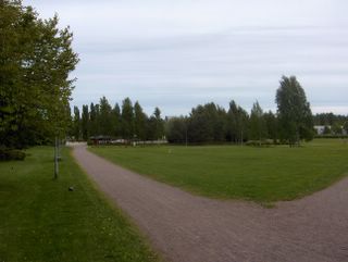
Euroopan mantereen alueella vallitsi edelleen rikkonainen pienten matala- ja korkeapaineiden ilmanpainekenttä, jossa ilmanpaine-erot olivat pieniä ja tuulet siten enimmäkseen heikkoja lukuun ottamatta meri- ym. paikallisia tuulia sekä ukkos- / kuuropuuskia. Tämä on etenkin alku- ja keskikesälle tyypillistä. Suomen eteläpuolelle oli edellisen tilanteen jälkeen vahvistunut yksi tällainen pieni korkeapaine, joka oli kuitenkin jo heikkenemässä tässä tilanteessa. Lapin tienoille oli muodostunut samalla pieni matalapaine. Siihen liittynyt kylmä rintama oli juuri ylittänyt eteläisen Suomen. Kuvassa nähdään siihen liittyneitä rintaman jälkipuolen untuvapilviä. Kuvaajan takana oli runsaammin pilviä; sisämaan kumpupilviä. Vain sisämaassa satoi aikaisemmin tänä päivänä paikallisia kuuroja ko. rintaman ylityksen aikana. Lämpötilat olivat nyt tyypillisen kesäisiä Etelä-Suomessa ollen päivisin vähän yli +20 astetta ja öisin n. +10 astetta. Helteiset ilmamassat olivat tässä vaiheessa kauempana Venäjällä ja lähimmillään Itä-Euroopassa Puolan tienoilla ja paikoin Baltiassa. Viileämmän sään vuoksi pienten järvien vedet olivat viilenneet +20 asteen tienoille ja merivesi oli vähän alle +20 astetta. Tässä viileämmässä ilmamassassa näin lämpimät vesistöt vaikuttivat kuitenkin yölämpötiloihin kohottamalla niitä parilla - kolmella asteella rannikoilla. Kuivuus vaivasi edelleen hieman etenkin etelärannikolla, jossa sateita oli tullut kesäkuussa vähemmän kuin sisämaassa. Tuo nurmikko oli muuttunut silti vain vähän ruskeammaksi esim. verrattuna 22. päivänä otettuun kuvaan. Erona siihen kuvaan tässä nähdään myös taivaan voimakkaampi sinisyys, joka johtui ko. tilanteessa olleen ilmamassan vähemmästä kosteudesta; vähemmän utua. Säätilanne: valitse 26.6.2006; Wetter3 A. Wetter3 B.In the area of continental Europe there prevailed further a broken pressure field of small low and high pressures, where the differences of the air pressure were small and the winds were therefore mostly weak not counted for sea breezes and other local winds and also shower- / thundergusts. This is typical of especially early and mid summer. Since the previous situation to the southern side of Finland there had been strengthened a one this kind of small high pressure, which was however allready weakening at this stage. At the same time a small low pressure had been formed around Lapland. A cold front associated with that had just been crossed southern Finland. In the picture we see the front's afterside cirrus clouds related to that. Behind the photographer there were more clouds; inland area cumulus clouds. Only in inland areas there came local showers earlier during this day at the time of the front's crossing. Temperatures were now typically summery in southern Finland and they were a bit over +20 C during afternoons and about +10 C at nights. Hot air masses were at this phase further away in Russia and at the closest in eastern Europe around Poland and locally in Baltic. Due to the cooler weather the waters of small lakes had been cooled down to about +20 C and the sea water was a bit less than +20 C. However in this cooler air mass such a warm water areas had an effect to the night temperatures as making them higher a couple of degrees by the coastal areas. The drought caused further a little harm especially by the southern coast, where there had been less rain than in inland areas during june. That lawn had been turned just a little bit more brown though as compared to the picture taken in the 22nd day. As a difference to that photo we see in here also the stronger blueness of the sky, which was resulted by the drier air mass in the situation; less haze. Weather condition: choose 26.6.2006; Wetter3 A. Wetter3 B.Helsingin Puistolan säätilasto kesäkuussa 2006 - Weather chart of Puistola, Helsinki in June 2006.Flickr 1 Flickr 2Tehoisa lämpösumma - The Effective Temperature Sum: 479,4
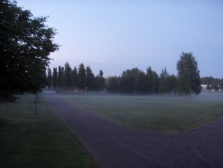
Edellisen kuvan jälkeen kesäsää oli palannut tässä vaiheessa lämpötilojen suhteen tavanomaiselle tasolle. Edellisenä päivänä ylin lämpötila oli +19,7 astetta ja kuvan tilanteessa yölämpötila oli alimmillaan +11,6 astetta. Tämän aiheutti Norjan länsireunalta Skandinavian pohjoispuolelle liikkunut matalapaine, joka toi lännestä heikon - kohtalaisen tuulen mukana viileämpää ilmaa. Hyvin lähelle Suomen itäpuolelle jäi kuitenkin erittäin helteistä ilmamassaa paikalleen; päivälämpötilat olivat siellä jopa +30 - +35 astetta. Suomen viileämmän ja idän kuuman ilman rajalla oli edelleen rintama voimakkainekin ukkosineen ja kuvassa ko. rintaman takapuolen untuvapilvisyyttä nähdään kaukana taivaanrannassa heikosti näkyvänä vyöhykkeenä. Tämä kuva on otettu siis yöllä ja tästä nähdään, kuinka valoisaa tähän aikaan vuodesta eteläisessä Suomessa on; kesäpäivänseisaus oli 21. päivänä. Keskiyön aurinko paistaa kuitenkin vain Napapiirin pohjoispuolella. Ko. alkanut päivä oli Juhannuspäivä. Kuvassa nähdään myös tyypillinen aamuyön sumu- / usvatilanne. Vallinneessa tyynessä säässä syntyy helposti ns. säteilysumua, jos ilman kosteus on riittävää. Kosteutta oli nyt maassa vähän enemmän kuin aikaisemmin em. rintaman sateiden ylitettyä ko. paikan edellisenä yönä. Kosteus jäi kuitenkin pinnalliseksi ja sateiden kuuroluonteen vuoksi paikalliseksikin ja siten kuivuus ei loppunut kokonaan. Kuivuudesta oli haittaa tähän mennessä silti lähinnä vain ruohovartisille kasveille. Säätilanne: valitse 24.6.2006; Wetter3 A. Wetter3 B.
After the previous picture summer weather had been returned to the average level at this stage considering the temperatures. In the previous day the maximum temperature was +19,7 C and in the situation of the picture the night temperature was +11,6 C at the lowest. That was caused by the low pressure moved from the western edge of Norway to the northern side of Skandinavia. It brought cooler air from the west along weak - moderate winds. However very near in the eastern side of Finland there remained very hot air mass in place; the afternoon temperatures were there even between +30 C and +35 C. Between the cooler air and the hot air of the east there was further a front with its also severe tunderstorms and in the photo we see the backside cirrus cloudyness of that front far away in the horizon as a faintly visible belt. So this photo is taken in the night and we can see from this, how light there is in southern Finland at this time of the year; the summer solstice was at the 21st day. However the midnight sun is shining only north from the Arctic Circle. The started day in question was Mid Summer's Day (a biggest celebration in summer in Finland). In the picture we see also a typical early morning fog / mist situation. In the prevailed calm weather so called radiation fog forms easily, if there's enough air moisture available. There was now moisture in the ground a little more than before as the precipitation of the mentioned front crossed this scene during the previous night. However the moisture remained superficial and also local due to the showery nature of the precipitation and therefore the drought didn't stop completely. The drought caused harm mainly to the herbacious plants only up to this moment though. Weather condition: choose 24.6.2006; Wetter3 A. Wetter3 B.
Helsingin Puistolan säätilasto kesäkuussa 2006 - Weather chart of Puistola, Helsinki in June 2006.Flickr 1 Flickr 2
Tehoisa lämpösumma - The Effective Temperature Sum: 455,7

Kuun 17. päivästä alkanut helleaalto jatkui tämän kuvan päivään asti. Heikko korkeapaine oli keskittynyt Suomen etelä- ja kaakkoispuolelle muutaman päivän ajan. Samalla Islannin ja Britannian väliin voimistunut matalapaine oli nyt muotoutunut Norjan länsireunalle. Sen myötä lännestä lähestyi edellisenä päivänä vaihteleva rintamasysteemi, joka jäi Suomen ylle ko. päiväksi ulottuen aina Alpeille asti. Tilanteessa vallitsi edelleen erittäin lämmin lounaistuuli ja ko. rintama jakoi tässä vaiheessa heti Suomen kaakkoispuolelle jopa yli +30 asteen helteitä. Rintaman myötä sää oli edellisestä päivästä lähtien runsaspilvistä; kovimmat helteet taittuivat ja ylimmät lämpötilat olivat n. +25 astetta Etelä-Suomessa. Nyt merituuli ei vaikuttanut. Ajoittain kohtalaisten tuulten ja pilvien takia yöt lämpenivät; alimmat lukemat olivat nyt paikoin jopa +20 asteen tienoilla, kuten tällä alueella +18,2 astetta. Ilmamassan lisääntynyt kosteus (utu samensi ilmaa yhä enemmän) sai ilman tuntumaan samalla tukahduttavammalta ja myös ukkosen mahdollisuus kasvoi. Jo edellisenä iltana ko. rintamassa esiintyi voimakkaita ukkosia esim. Puolassa. Etelä-Suomessa esiintyi paikallisia kuuroja edellisenä päivänä ja yönä. Sitten ko. päivänä myöhemmin illalla Baltiassa kehittyi ko. rintamasysteemiin ankaria ukkosia, joista osa pääsi Suomenlahden yli tämän paikan itäpuolelle. Ukkoset kuitenkin heikkenivät tyypillisesti yötä kohden auringon vaikutuksen vähennyttyä. Ko. paikalla saatiin vain kohtalaista kuurottaista sadetta seuraavana yönä. Kuvassa nähdään ko. rintamasysteemin pilvisyyttä ilman kuuro- / ukkospilviä; untuva-, hahtuva- ja kumpukerrospilviä, joista jälkimmäiset kaksi olivat kostean ja lämpimän ilmamassan tapaan hyvin konvektiivisia. Niissä oli siten runsaasti kukkakaalimaisia kumpuosia ja vallinharjamaisia piirteitä. Kuvan nurmikko oli leikattu äskettäin, vaikka jo parisen viikkoa jatkuneen kuivuuden takia sen kasvu oli huomattavasti heikentynyt. Tämän hellejakson ansiosta vesistöt lämpenivät tehokkaasti. Merivesi oli rannikolla paikoin n. +20 asteista ja pienet järvet olivat jo useita päiviä jopa n. +25 asteen lämpöisiä. Erinomaiset uimakelit siis vallitsivat. Säätilanne: valitse 22.6.2006; Wetter3 A. Wetter3 B.
The heatwave started since the 17th day of the month continued up to this day. A weak high pressure had been concentrated to the southern and southeastern side of Finland for the couple of past days. At the same time a low pressure strengthened between Iceland and British Isles was now transformed to the western edge of Norway. Due to that a variable frontal system approached from the west during the previous day and in this day it stayed over Finland reaching as far as The Alps. There prevailed further a very warm southwesterly wind and this front devided at this stage immediately to the southeastern side of Finland an air mass of even hotter than +30 C temperatures. Due to the front the weather was more cloudy since the previous day; the heatwave weakened and the maximum temperatures were about +25 C in southern Finland. Now the sea breeze didn't have an effect. Due to the occasionally moderate winds and the clouds the nights got warmer; the minimun readings were now even around +20 C, as in this area +18,2 C. The increased moisture of the air (haze blurred the air further more) caused the air to feel more sultry at the same time and the possibility of thunder increased also. Allready during the previous evening there appeared strong thunderstorms in the front in question for example in Poland. In southern Finland there appeared local showers during the previous day and night. Then later in the evening at this day there evolved severe thunderstorms in the front in question in Baltic and some of them had a chance to cross The Gulf Of Finland to the eastern side of this place. However the thunderclouds weakened typically towards the night as the effect of the sun decreased. At this place there was only moderate showery rain during the next night. In the picture we see the cloudyness of the mentioned frontal system without cumulonimbus clouds; cirrus, altocumulus and stratocumulus clouds and the latter two of them were in the way of the moist and warm air mass very convective. Therefore they had a lot of cauliflowery cumulus parts and altocumulus castellanus type of shapes. The lawn in the picture had recently been mowed, allthough the growth of it had signifigantly been weakened due to the drought continued allready for a couple of weeks. Thanks to this hot period the water areas warmed up effectively. The sea water was locally by the coast about +20 C and small lakes had been allready for several days even about +25 C warm. So excellent swimming conditions prevailed. Weather condition: choose 22.6.2006; Wetter3 A. Wetter3 B.
Helsingin Puistolan säätilasto kesäkuussa 2006 - Weather chart of Puistola, Helsinki in June 2006.Flickr 1 Flickr 2
Tehoisa lämpösumma - The Effective Temperature Sum: 430,7

Kesän kolmas helleaalto oli päällä kuvan tilanteessa. Ylimmät lämpötilat olivat 17. päivästä lähtien yli +25 astetta etelärannikollakin ja kuvauspäivänä saavutettiin +27,6 astetta. Etelä-Suomen sisämaassa ei kuitenkaan tällä kertaa ollut edellistä helleaaltoa lämpimämpää; ylimmät lukemat olivat paikoin n. +30 astetta. Rannikon ja sisämaan päivälämpötilojen aikaisempaa pienempi ero johtui lämmenneestä merestä (nyt jo selvästi yli +15 astetta ja matalissa rannikkovesissä n. +20 astetta) ja sen takia heikommasta merituulesta. Tämä helteinen sää muodostui suureen osaan Eurooppaa kesälle tyypilliseen tapaan, jossa 16. - 19. päivinä selviä matalapaineita oli lähinnä pohjoisella Atlantilla ja Euroopan mantereen alueella oli laaja, mutta rikkonainen korkeapaine. Tilanteeseen syntyi kaksi melkolailla sijoillaan vallinnutta rintamavyöhykettä; yksi Atlantilta Pohjois-Skandinavian yli ja etelämpänä toinen Länsi- ja Keski-Euroopan yli Venäjälle. Rintamalinjojen kohdilla oli itään ja koilliseen liikkuneita pieniä matalapaineita. Eteläisempien kohdilla kehittyi etenkin iltapäivisin paikoin ankariakin ukkosia; ukkosten painopisteet olivat Keski-Euroopassa, Espanjan tienoilla sekä toisaalta kauempana Venäjällä. Etelä-Suomi jäi ko. ajaksi näiden kahden rintamavyöhykkeen väliin, johon kehittyi Euroopan toiseksi helteisin ilmamassa. Siinä sää oli kuvan tapaan pääosin täysin selkeää; ajoittain oli vähän untuvapilviä ja iltapäivisin sisämaan kumpupilviä. Utu lisääntyi vähän kuvauspäivää kohden ja ilmavirtaukset olivat kuvauspäivän voimistunuttta lounaistuulta lukuun ottamatta koko ajan erittäin heikkoja ja öisin oli jopa täysin tyyntä (yölämpötilat olivat paikoin vain n. +10 astetta helteestä huolimatta). Iltapäivisin tuntuivat lähinnä vain isojen vesistöjen paikalliset merituulet. Kuvassa nähdään, kuinka edelleen kehittynyt kuivuus alkoi vaivaamaan tuota nurmikkoa; vihreä väri oli edelleen haalistunut ja paikoin oli jo ruskeiksi kuivuneita kohtia. Kasvukausi eteni kuitenkin nopeasti ja se oli nyt n. viikon verran edellä tavanomaista aikataulua. Kosteilla alueilla kasvit saivat tästä lämmöstä vielä täyden hyödyn; mm lupiini (Lupinus polyphyllus) oli jo täydessä kukassa ja Suomessa myös yleinen maitohorsma (Epilobium angustifolium) aloitti paikoin kukintaansa. Säätilanne: valitse 19.6.2006; Wetter3 A. Wetter3 B.
The third heatwave of the summer was on in the situation of the picture. The maximum temperatures were more than +25 C even by the southern coast since the 17th day and at the photoshooting day +27,6 C was reached. However in the inland areas of southern Finland there wasn't warmer this time than during the previous heatwave; the maximum readings were locally about +30 C. The more narrow difference between the afternoon temperatures of the inland areas and the coastal region was resulted by the warmed up sea (now clearly more than +15 C and on low coastal waters about +20 C) and due to that by the weaker sea breeze. This hot weather formed into most of Europe in a typical way of summer, where between 16th and 19th days there were clear low pressures mainly in northern Atlantic and over the continent of Europe there was a wide, but broken area of high pressure. In the situation there formed two frontal borderlines, which lingered rather well in place; one was lined up from Atlantic and crossing northern Skandinavia and the other one was more south crossing western and Middle Europe into Russia. In the places of the frontal borderlines there were small low pressures moving to the east and northeast. In the places of the more southern low pressures there evolved especially during afternoons also severe thunderstorms; the emphasis of the thuderstorms were in Middle Europe, around Spain and on the other hand more far away in Russia. Southern Finland remained between these two frontal borderlines, where there formed the second hottest air mass of Europe. In it the weather was in the way of the photo mainly completely clear; occasionally there appeared a little amount of cirrus clouds and during afternoons cumulus clouds in inland areas. Haze increased a little towards the photoshooting day and the airflows were all the time very weak not counted for the strengthened southwesterly wind of the photoshooting day and during nights it was even completely calm (the night temperatures were only about +10 C despite the heatwave). During afternoons only local sea breezes of the large water areas were mainly felt. In the picture we see, how the further progressed drought started to harm that lawn; the green colour had been paled further and there were allready locally spots dried up brown. However the growing season evolved fast and it was now about one week ahead of the average time table. In moist places plants reseaved yet a full benefit from this warmth; for example Lupin / Bigleaf Lupine (Lupinus polyphyllus) was in full bloom and also common in Finland Fireweed (Epilobium angustifolium) started locally the blooming. Weather condition: choose 19.6.2006; Wetter3 A. Wetter3 B.
Helsingin Puistolan säätilasto kesäkuussa 2006 - Weather chart of Puistola, Helsinki in June 2006.Flickr 1 Flickr 2
Tehoisa lämpösumma - The Effective Temperature Sum: 381,5
 Edelliseen kuvaan verrattuna tässä ei ollut samassa maiseman kohdassa kumpupilven varjoa. Muutoin tilanne oli sama. Kasvukausi oli juuri päättyneen toisen helleaallon (ensimmäinen oli toukokuun alussa) myötä edennyt jo muutamia päiviä edelle tavanomaisesta. Tässä vaiheessa Etelä-Suomen sisämaan kasvukausi oli vielä n. viikon edellä etelärannikon tilannetta, koska merituuli oli kevään ja alkukesän mittaan viilentänyt niin paljon etelärannikon säätä. Merituulen aiheuttama ero ei ole joka vuosi näin suuri. Kuvassa olevalla nurmikolla nähdään vaaleina laikkuina voikukkien (Taraxacum officinale) siemenvaiheeseen kehittyneitä mykeröitä lievän kuivuuden aiheuttaman haalean vihreän sävyn mukana. Voikukka on tyypillinen kotimainen maisemakasvi Suomessa ja nyt toinen yleinen amerikkalaista alkuperää oleva luontaisten niittyjen kasvi eli lupiini (Lupinus polyphyllos) oli alkanut kukkimaan komeasti ko. helleaallon ansiosta. Sen kanssa samaan aikaan kukinnan aloitti myös koiranputki (Anthriscus sylvestris). Näiden kasvien kukinnat kuuluvat Etelä-Suomessa tyypillisesti kesäpäivänseisauksen aikaan, joka oli pian kohdalla. Kesäpäivänseisaus merkitsee keskikesää astrologisessa mielessä, mutta lämpötilojen mukaan keskikesä on Suomessa keskimäärin heinäkuun loppupuolella. Säätilanne: valitse 15.6.2006; Wetter3 A. Wetter3 B.As compared to the previous picture in here there wasn't a shadow of the cumulus cloud in the same spot of the landscape. Otherwise the condition was the same. The growing season had been progressed due to the second heatwave (the first was in early may) allready a few days ahead of the average. At this stage the growing season of the inland areas of southern Finland was yet about one week ahead of the situation by the southern coast, because during spring and early summer the sea breeze had been cooled down the weather in such a way by the southern coast. The difference caused by the sea breeze isn't this large every year. On the lawn in the picture we see as light patches flower heads of Dandelion (Taraxacum officinale) evolved into fruiting stage among the pale green tone caused by a slight drought. Dandelion is a typical native landscape plant in Finland and now an other common plant of natural meadows and of american origin in other words Bigleaf Lupine / Garden Lupin (Lupinus polyphyllos) had been started to bloom magnifigently due to the mentioned heatwave. In the same time with it also Cow Parsley / Wild Chervil (Anthriscus sylvestris) started the blooming. In southern Finland the flowerings of these plants are typically a part of the summer solstice time, which was soon at hand. The summer solstice means mid summer in astrological sence, but according to the temperatures mid summer is in Finland on an average during latter part of july. Weather condition: choose 15.6.2006; Wetter3 A. Wetter3 B.Helsingin Puistolan säätilasto kesäkuussa 2006 - Weather chart of Puistola, Helsinki in June 2006.Flickr 1 Flickr 2Tehoisa lämpösumma - The Effective Temperature Sum: 325,3
 Edellisenä iltana ja yöllä kylmä rintama ylitti tämän paikan. Rintamaan liittyi paikoin sade- ja ukkoskuuroja, mutta etelärannikolle tullessaan rintama oli kuivunut niin, että ko. alueelle osui vain hyvin vähäisiä kuuroja eikä ukkosta ollenkaan. Sama oli havaittavissa lähes koko etelärannikolla. Tämä kuuropilvien heikkeneminen johtui tyypillisesti vielä viileästä merestä. Kesäkuukausina sekä loppukeväällä ja alkusyksyllä on tyypillistä, että sateet ovat voimakkaan termiikin myötä usein kuuroluonteisia. Senkin takia konvektiiviset tilanteet ovat hyvin vaihtelevia, jolloin sademäärien paikalliset erot ovat suuria lyhyelläkin matkalla kahden eri tarkastelupisteen välillä. Tässä on siis huomioitava, että näinä aikoina tämän seurantapaikan ja ilmoitetun Helsingin Puistolan säätilaston välillä voi olla hyvin suuria eroja sademäärissä, vaikka ko. paikat ovat muutoin samankaltaisia pienen etäisyyden vuoksi. Mainitsen erikseen, jos ero on ollut hyvin suuri tai selvä. Tässä kuvassa em. rintaman jälkeen vallitsi edellistä päivää viileämpi luoteistuuli; iltapäivän lämpötila jäi +19,4 asteeseen. Ilmamassa oli myös aikaisempaa kuivempi, jolloin taivaan sinisyys oli voimakkaampaa. Tässä polaarisessa ilmamassassa sisämaassa oli tyypillisesti matalia kumpupilviä, jotka ajautuivat lähelle merta, kun luoteistuuli heikensi merituulen vaikutusta. Yksi tällainen kumpupilvi pimensi varjollaan tämän kuvan maisemaa verrattuna minuuttia myöhemmin otettuun ylempään kuvaan. Säätilanne: valitse 15.6.2006; Wetter3 A. Wetter3 B.During the last evening and at night a cold front crossed this place. There was locally showers and thundershowers associated with the front, but as it came to the southern coast it dried up in such a way, that there was only very weak showers and not thunder at all in this area. The same was observed in allmost all southern coast. This weakening of the showers was typically caused by the yet cool sea. During summer months and both late spring and early autumn it is typical, that the precipitation is many times showery in nature due to the strong thermal. Therefore also convective situations are very variable, which causes great differences to the amount of precipitation even in the short distance between two different observation posts. So it's noticeable in here, that during these times there can be big differences in the amount of precipitation between this and the mentioned weather chart of Puistola, Helsinki, allthough these places are otherwise similar due to a short distance between them. I will note, if the difference have been very large or clear. In this picture there prevailed a cooler northwesterly wind after the mentioned front; the afternoon temperature stayed at +19,4 C. The air mass was also drier than before and so the blueness of the sky was stronger. In this polaric air mass there was in inland typical flat cumulus clouds, which floated near the sea, as the northwesterly wind overruled the effect of the sea breeze. One this kind of cumulus cloud shadowed the landscape in this picture as compared to the picture above taken one minute later. Weather condition: choose 15.6.2006; Wetter3 A. Wetter3 B.Helsingin Puistolan sätilasto kesäkuussa 2006 - Weather chart of Puistola, Helsinki in June 2006.Flickr 1 Flickr 2
Tehoisa lämpösumma - The Effective Temperature Sum: 325,3

Sää lämpeni 10. päivästä lähtien nopeasti koko Suomessa ja muodostuneen helleaallon huippu saavutettiin tätä kuvaa edeltävänä päivänä. Silloin etelärannikollakin oli n. +25 astetta ja sisämaassa oli paikoin jopa n. +30 astetta. Tämä johtui korkeapaineesta, joka vahvistui aluksi Suomen länsipuolelle 10. päivänä. Sitten se viipyi parisen päivää Suomen eteläpuolella kierrättäen lounaasta ja lännestä Länsi-Euroopassa aikaisemmin ollutta helteistä ilmamassaa. Kun heikko kylmä rintama ylitti tämän paikan 10. päivänä, niin sen jälkeen pilvisyys oli hyvin vähäistä. Sisämaassa esiintyi tyypillisiä kumpupilviä, mutta niidenkin määrä oli ajoittain olematon etenkin saapuneessa keskileveysasteiden ilmamassassa parina edellisenä päivänä. Utu lisääntyi hieman päivä päivältä. Merituuli-ilmiö oli jälleen voimakas helteessä, koska alkukuun viileän sään vuoksi merivesi oli vain n. +10 asteista. Nyt se lämpeni kuitenkin +15 asteen tienoille ja pienet vesistöt saavuttivat ensi kertaa +20 asteen rajan tänä kesänä. Kuvauspäivänä kylmä rintama oli kuitenkin lähestymässä luoteesta ja sen merkkinä kuvaushetkellä oli voimakas lounaistuuli (kuvan taipuneet puut) ja Etelä-Suomen sisämaassa esiintyi rintaman kohdalla ko. iltana ukkoskuuroja paikoitellen. Kunnon sadetta ei ollut tällä paikalla tähän mennessä koko kuussa ja sen vuoksi kuivuutta alkoi näkymään tuolla nurmikolla; vähän haalistunut vihreä sävy ja käytävän reunojen ruskeaksi kuivuneet kasvit. Kasvukausi oli edennyt nyt kuitenkin nopeasti ja etumatkaa tavanomaiseen alkoi muodostua. Puut ja pensaat olivat saavuttaneet nyt lopullisen tumman kesäsävyn. Kesä oli siis vihdoinkin saapunut koko voimalla Suomeen ja esim. mainittu helleaalto täytti uimarannat ensimmäisen kerran kunnolla. Säätilanne: valitse 14.6.2006; Wetter3 A. Wetter3 B.
The weather got warmer fast from the 10th day onwards in whole Finland and the climax of the formed heatwave was reached in the day before this picture. At that time there was about +25 C even by the southern coast and in inland areas there was locally even about +30 C. This was resulted by a high pressure, which strengthened to the western side of Finland at first in the 10th day. Then it stayed for a couple of days in the southern side of Finland circulating from the southwest and west the same hot air, that had earlier been in western Europe. As a weak cold front crossed this place at the 10th day, since then the amount of clouds was very small. In the inland areas appeared typical cumulus clouds, but the amount of even them was occasionally nonexistent especially in the arrived middle latitude air mass of the previous couple of days. Haze increased a little day by day. The sea breeze phenomenon was strong again in the heatwave, because due to the cool weather of the early month the sea water was only about +10 C. However now it warmed around +15 C and small waters warmed for the first time to +20 C during this summer. However a cold front was approaching from the northwest and as a mark for that there was a strong southwesterly wind (the bended trees in the picture) in the moment of the photo and in inland areas of southern Finland there appeared thundery showers locally during this evening in the place of the cold front. There hadn't been enough rain at this place during the whole month up to this point and so drought started to appear in that lawn; a slightly paled green colour and plants dried into brown on the edges of the path. However the growing season had now been progressed in a fast pace and an advance compared to the average started to form. Trees and shrubs had now been reached the ultimate dark green summer tone. So the summer had finally been arrived into whole Finland with a full force and for example the mentioned heatwave packed beaches full of swimmers for the first time properly this summer. Weather condition: choose 14.6.2006; Wetter3 A. Wetter3 B.
Helsingin Puistolan säätilasto kesäkuussa 2006 - Weather chart of Puistola, Helsinki in June 2006.Flickr 1 Flickr 2
Tehoisa lämpösumma - The Effective Temperature Sum: 314,5
Tavanomaista viileämpi sää jatkui edelleen edellisen kuvan jälkeen ja päivälämpötilat jäivät jopa vähän alle +15 asteen. Kuvauspäivänä alkoi sään lämpeneminen ja ylin lämpötila oli jo +18,1 astetta pilvistä huolimatta. Kaikkina päivinä oli lähes koko ajan niin pilvistä, että lämpötilat pysyivät öisin +5 ja +10 asteen välillä, jolloin hallaa ei ollut. Edellisessä tilanteessa ollut matalapaine väistyi heikon korkeapaineen selänteen tieltä ja pohjoistuulet heikkenivät nopeasti; 7. ja 8. päivinä oli ajoittain jopa täysin tyyntä. Niinpä viileä ilmamassa ei päässyt vaihtumaan lämpimämpään ja runsaspilvinen sää vähensi samalla auringon lämmitystä päivisin; taivaalla vallitsivat erityisesti ainakin kumpukerros-, hahtuva- ja kuuropilvet. Sadetta tuli kuitenkin vain vähäisinä kuuroina 8. päivänä heikosta kylmästä rintamasta. Kuvauspäivänä Lapin pohjoispuolelle saapuneeseen matalapaineeseen liittynyt lämmin rintama oli ylittämässä eteläistä Suomea luoteesta. Kuvassa nähdään ko. rintaman tyypillisiä verhopilviä sen suuntaisina viiruina. Tässä vaiheessa luoteistuuli oli vähän voimistumassa. Kasvukauden hitaan etenemisen vuoksi sen viive tavanomaiseen oli kasvanut nyt jo n. viikkoon. Tämä tiesi mm. kotipihlajan (Sorbus aucuparia) kukinnan pitkittymistä ja kuvassa olevaa nurmikkoa ei oltu leikattu vieläkään kolmatta kertaa. Säätilanne: valitse 9.6.2006; Wetter3 A. Wetter3 B.
The cooler than normal weather continued further since the previous picture and the afternoon temperatures stayed even a little under +15 C. In the photoshooting day warming up of the weather started and the maximum temperature was allready +18,1 C despite the clouds. During all days the cloudyness was so plentyfull allmost all the time, that at nights the temperatures stayed between +5 C and +10 C and so ground frost didn't appear. The low pressure of the previous situation moved aside as a weak ridge of high pressure replaced it and the northerly winds calmed down quickly; during the 7th and 8th days it was even completely calm occasionally. Therefore the cool air mass wasn't able to change into warmer air mass and the plentyfully cloudy weather decreased the warming effect of the sun at the same time during afternoons; there prevailed especially at least stratocumulus, altocumulus and cumulonimbus clouds in the sky. However there were weak showers only from a weak coldfront during the 8th day. During the photoshooting day a warm front associated with a low pressure arrived to the northern side of Lapland was crossing southern Finland from the northwest. In the picture we see typical altostratus clouds of that front assembled in stripes according to the direction of it. At this stage northwesterly winds were picking up a bit. Due to the slow progress of the growing season the delay of it had now been formed allready into about one week. This meant for example prolonged blooming of European Mountain Ash / Rowan (Sorbus aucuparia) and the lawn in the picture hadn't been mowed even now for the third time. Weather condition: choose 9.6.2006; Wetter3 A. Wetter3 B.
Helsingin Puistolan säätilasto kesäkuussa 2006 - Weather chart of Puistola, Helsinki in June 2006.Flickr 1 Flickr 2
Tehoisa lämpösumma - The Effective Temperature Sum: 253,7
 Suomi kuului edellisen kuvan jälkeen tavanomaista viileämmän ilmamassa piiriin. Lappiin saapunut matalapaine heikkeni 3. - 4. päivinä paikoilleen, mutta Suomen kaakkoispuolelle voimistui uusi matalapaine 4. - 6. päiviksi. Samalla Britteinsaarilla oli korkeapaine, josta ulottui erityisesti 4. - 6. päivinä selänne Suomen länsipuolelle. Tämän myötä erityisesti 5. ja 6. päivinä vallitsi voimakas ja viileä pohjois- ja koillistuuli, jolloin ko. iltapäivän lämpötila oli vain +12,7 astetta. Edellisenä päivänä ylin lämpötila oli +17,8 astetta ennen tuulen selvää voimistumista. Tuulten ja pilvien takia yölämpötilat pysyivät +5 ja +10 asteen välillä, joten hallaa ei ollut. Jatkuvaa sadetta saatiin 3.6. iltapäivällä, jolloin päivälämpötila jäi vain +10,4 asteeseen. Kaakossa nyt olleesta matalapaineesta ei ulottunut tarkastelupaikalle sadetta, mutta kuvan tapaan runsaasti pilviä. Ko päivänä vallitsivat tyypillisesti kumpukerrospilvet vaihtelevina lauttoina peittäen ajoittain koko taivaan. Kylmä polaarinen ilmamassa oli kuivaa ja siten kuvassakin ilma oli kirkasta ja pilvien muodot näkyivät hyvin. Viileästä säästä johtuen kasvukausi eteni hitaasti, jonka vuoksi kuvassa vasemalla rusokirsikassa (Prunus sargentii) oli edelleen hieman kevätväriä jäljellä. Nurmikkokin kasvoi sen verran hitaasti, että sitä ei oltu leikattu vielä kolmatta kertaa. Kasvukauden viive tavanomaiseen oli nyt muutamia päiviä. Säätilanne: valitse 6.6.2006; Wetter3 A. Wetter3 B.
Since the previous picture Finland remained in the cooler than normal air mass. The low pressure arrived from the west into Lapland weakened in place during the 3rd and 4th days, but a new low pressure strengthened to the southeastern side of Finland for the 4th to 6th days. At the same time there was a high pressure over British Isles and a ridge of high pressure reached from it to the western side of Finland especially during 4th to 6th days. Due to that especially during the 5th and 6th days strong and cool northern - northeastern winds prevailed, when this afternoon's temperature was only +12,7 C. In the previous day the maximum temperature was +17,8 C before the wind picked up significantly. Due to the winds and clouds the night temperatures stayed between +5 C and +10 C and therefore ground frost didn't appear. A continous rain came in the afternoon of the 3rd day, when the afternoon temperature stayed at only +10,4 C. From the low pressure that was now in the southeast there didn't reach precipitation into the observation post, but in the way of the photo plenty of clouds. During this day there prevailed typically stratocumulus clouds in various layers blanketing the whole sky occasionally completely. The cold polaric air mass was dry and so the air was clear also in the picture and shapes of the clouds were finely visible. Due to the cool weather the growing season progressed slowly and therefore there was further a little spring colour left in Sargent Cherry (Prunus sargentii) in the picture on the left. Also the lawn grew slowly in such a way, that it hadn't been mowed yet for the third time. The delay of the growing season compared to the average was now a few days. Weather condition: choose 6.6.2006; Wetter3 A. Wetter3 B.
Helsingin Puistolan säätilasto kesäkuussa 2006 - Weather chart of Puistola, Helsinki in June 2006.Flickr 1 Flickr 2
Tehoisa lämpösumma - The Effective Temperature Sum: 235,5

Määritelmän mukaan kesä alkaa eteläisessä Suomessa, kun vuorokauden keskilämpötila kohoaa pysyvästi yli +10 asteen. Näin käy yleensä vähän toukokuun puolenvälin jälkeen. Tänä vuonna kesä yritti alkaa poikkeuksellisen aikaisin toukokuun alussa helleaallon takia, mutta sittemmin viileän sään takia tuo em. raja-arvo juuri ja juuri ylittyi pysyvämmin vasta toukokuun 30. päivästä lähtien. Edellisen kuvan jälkeen etelästä nousi voimakas, mutta pieni matalapaine. Se liikkui Suomen itärajaa viistäen pohjoiseen ja siihen liittynyt sadealue jäi hyvin täpärästi tulematta tälle seurantapaikalle; vähän idempänä satoi melko runsaasti. Edellisenä päivänä pohjoistuuli oli kuitenkin voimakasta ja sää runsaspilvistä. Kuvauspäivänä tuulet heikkenivät vähän ja kääntyivät länteen uuden matalapaineen lähestyttyä lännestä Lappia. Heikon korkeapaineen selänteen ansiosta kuvaustilanteessa vallitsivat vain kumpupilvet ja niistä syntyneet kumpukerrospilvet. Ne etenivät tuulen mukana melko lähelle merta (kuten kuvasta nähdään); yleinen ilmavirtaus kumosi siis vähän merituulta. Samasta syystä myös rannikolla oli tavanomaisen lämmintä sisämaan tapaan; ko. päivänä ylin lukema oli +19,4 astetta. Tuulen ja pilvien vuoksi öisin oli kohtuullisen lämmintä. Kasvukausi oli edennyt edelleen tavanomaisessa aikataulussa ja se nähtiin mm. tuon kuvan vasemman laidan rusokirsikan (Prunus sargentii) lähes kadonneesta kevätväristä. Nurmikko oli jälleen leikattu ja sen vihreys oli tyypillisen voimakasta tässä vaiheessa. Säätilanne: valitse 2.6.2006; Wetter3 A. Wetter3 B.
According to the definition summer starts in southern Finland, when the daily average temperature rises permanently above +10 C. That happens usually a little after mid may. This year summer tried to start unusually early at early may due to the heatwave, but since then because of the cool weather that limit was barely topped more permanently only from the 30th of may onwards. After the previous photo a strong, but small low pressure came from the south. It moved along the eastern border of Finland to the north and the precipitation area associated with it missed narrowly this observation post; a little more eastwards it rained rather plentyfully. However during the previous day northerly winds were strong and the clouds appeared plentyfully. During the photoshooting day the winds eased a bit and they turned to the west as a new low pressure approached Lapland from the west. Due to a weak ridge of high pressure there prevailed only cumulus clouds and stratocumulus clouds born from them. They proceeded rather near the sea (as we can see from the photo) with the wind; in other words the general airflow overruled a little the sea breeze. Due to the same reason by the coast there was typically warm in the way of the inland areas; during this day the maximum temperature was +19,4 C. Due to the clouds and winds there were moderately warm also at nights. The growing season had been progressed further according to an average time table and it was observed for example from the allmost disappeared spring colour of Sargent Cherry (Prunus sargentii) on the left side of the picture. The lawn had been mowed again and the green tone of it was typically strong at this stage. Weather condition: choose 2.6.2006; Wetter3 A. Wetter3 B.
Helsingin Puistolan säätilasto kesäkuussa 2006 - Weather chart of Puistola, Helsinki in June 2006.Flickr 1 Flickr 2
Tehoisa lämpösumma - The Effective Temperature Sum: 211,1