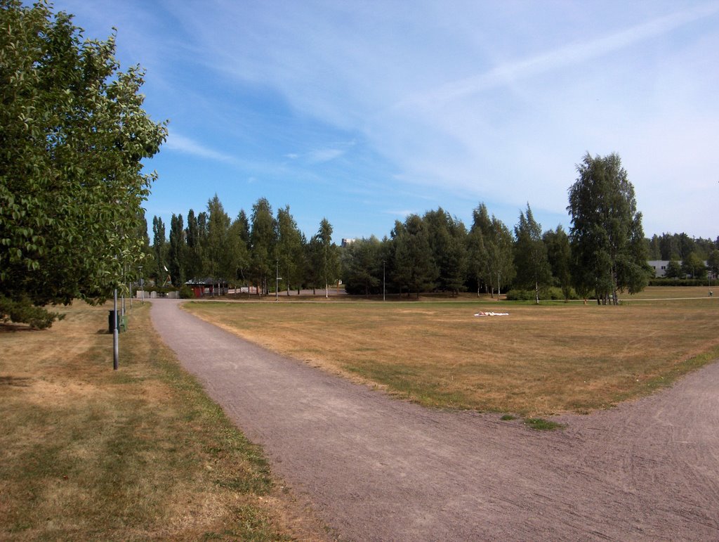
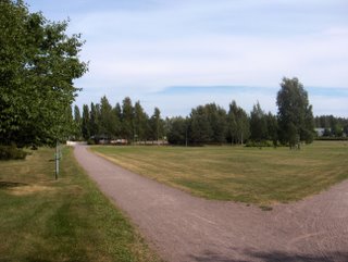
Edellisen kuvan jälkeen Euroopassa vallitsi yhä ilmanpainekenttä hyvin pienine ilmanpaine-eroineen ja vain Atlantilla sekä Pohjois-Venäjällä oli kunnon matalapaineet. Länsi- ja Keski-Euroopan helteisen ilmamassan pienet matalapaineet eivät olleet kuitenkaan vähäpätöisiä, sillä tyypillisesti niiden alueilla esiintyi paikoin ankaria ukkosia. Suomeen ja tähän tarkastelupaikkaan liittyen Etelä-Suomen ylle jäi aluksi edellisen tilanteen rintama ja eteläisin Suomi kuului kesän kuudennen (17.7. ei laskettu mukaan) helleilman piiriin; ylin lukema +27,2 astetta oli 25. päivänä. Tällöin tuli edelleen paikoin sade- ja ukkoskuuroja 25. päivän iltapäivällä, mutta lähinnä vain sisämaassa ja kuvauspaikalla ei yhtään. Kahtena edellisenä päivänä Suomen länsipuolella oli korkeapaine ja vähän voimistuneessa pohjoistuulessa ilmamassa kuivui ja viileni (ylin lukema oli edellisenä päivänä +21,5 astetta). Siinä vallitsivat lähinnä vain hyvin vähäiset iltapäivän kumpupilvet. Kuvauspäivänä em. korkeapaine oli jakautumassa kahtia ja Etelä-Skandinaviaan muodostunut matalapaine alkoi liikkua siitä välistä Suomen eteläpuolelle. Kuvassa nähdään matalapaineeseen liittyneen lämpimän rintaman untuvapilviä eteläisillä taivaalla rintaman suuntaisena kilpenä. Muita pilvilajeja ei tilanteessa ollut. Rintaman eteläpuolelle jäi Euroopassa edelleen vaikuttanut hyvin helteinen ilmamassa, joka ulottui lähimmillään Etelä-Ruotsiin. Rintaman sateet eivät ulottuneet paikalle, joten kuivuus eteni edelleen ja nyt se näkyi jo tämän alueen puissa. Kuvassa keskeltä vähän vasemmalle nähdään rauduskoivujen (Betula pendula) lehtien kellastuneen, vaikka normaalisti tämä kasvupaikka on hyvin kostea; pohjavesi on korkealla ja maalaji on melko savinen. Tämä kuvasti kuivuuden merkittävää erikoisuutta. Tässä vaiheessa kuivuus edesauttoi jo metsäpalojen syntymistäkin niin Suomessa kuin lähialueilla. Säätilanne: valitse 28.7.2006; Wetter3 A. Wetter3 B.After the previous picture there prevailed further an air pressure field in Europe, where there were small air pressure differences and only in Atlantic and Russia there were proper low pressures. However small low pressures in the hot air mass in western and middle Europe weren't insignificant as in their areas there appeared locally severe thunder in a typical way. Concerning Finland and this observation post the front of the previous situation remained at first over southern Finland and the southernmost Finland belonged in the sixth hot air mass of the summer (17th of July not counted for); the highest reading was +27,2 C at the 25th day. At that time there came further local showers and thunder during the 25th day's afternoon, but mainly in inland areas and not a single one in this place. During the previous two days there was a high pressure in the western side of Finland and in a little strengthened northerly wind the air mass got cooler and drier (the maximum reading in the previous day was +21,5 C). In there prevailed only minor cumulus clouds of the afternoon. In the photoshooting day the mentioned high pressure was dividing into half and a low pressure formed in southern Skandinavia started to move southern side of Finland between there. In the picture in the southern horizon we see cirrus clouds in the form of a shield according to the direction of a warm front associated with the low pressure. There weren't other cloud types present in the situation. The hot air mass further affected Europe was left southern side of that front. The hot air reached southern Sweden at the closest. The precipitaiton of that front didn't reach the area and so the drought progressed further and now it was showing allready in the trees of this scene. In the picture a little left of the middle we see the leaves of Silver Birches (Betula pendula) turned a bit yellow, allthough normally this locality is very moist; the ground water is high and the soil type is rather clayish. This was presenting the significant peculiarity of the drought. At this stage the drought was allready helping the formation of forest fires as well both in Finland and nearby areas. Weather condition: choose 28.7.2006; Wetter3 A. Wetter3 B.
Helsingin Puistolan säätilasto heinäkuussa 2006 - Weather chart of Puistola, Helsinki in July 2006.Flickr 1 Flickr 2
Tehoisa lämpösumma - The Effective Temperature Sum: 935
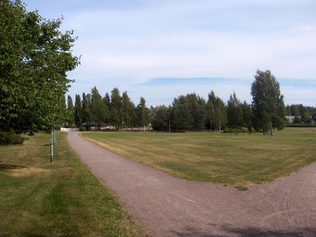
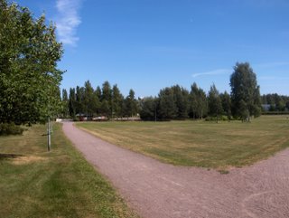
 Kuivuus oli tässä vaiheessa edennyt jo lähes ennätyksellisen pitkälle. Sadan viime vuoden aikana on ollut kuivempaa vain kesällä 1955. Edes edellisen tilanteen sade ei helpottanut asiaa yhtään etelärannikolla, mutta sisämaassa kuluvana kuuna sattuneiden kuurosateiden myötä kuivuus oli siellä paljon vähäisempää. Kuvan nurmikko pysyi edelleen ruskeana ja se ei alkanut kasvaa. Kuivimpien paikkojen puut ja pensaat puistoissa ja puutarhoissa olivat myös jo vaurioituneet (olivat ennenaikaisesti ruskassa tai lehdet kuivuneet korpuiksi); herkimmin kuivuudesta kärsivät esim. rauduskoivu (Betula pendula), metsävaahtera (Acer platanoides) ja kotipihlaja (Sorbus aucuparia). Edelliseksi päiväksi matalapaineen tilalle muodostui pieni korkeapaineen selänne lounaasta kohti Etelä-Suomea ja sää selkeni lähes tyystin. Ilmanpainekentässä oli Euroopan alueella edelleen hyvin pienet ilmanpaine-erot. Kunnollisia matalapaineita rintamineen oli vain Atlantilla ja toisaalta Venäjällä, missä voimakas matalapaine kierrätti pohjoisesta hyvin viileää ilmaa. Suomessa oli tänä päivänä liikkumassa heikko kylmä rintama keskisen Suomen päällä hitaasti etelään; se aiheutti Etelä-Suomessa iltapäivällä ja illalla paikoin ukkosta. Eräs ukkosjäänne antoi kuvausalueen lähellä paikoin sadekuuroja illalla. Ilmamassa alkoi lämmetä Etelä-Suomessa em. korkeapaineen selänteen myötä ja ko. päivän ylin lukema oli jo +25,8 tällä alueella. Kuvassa etelätaivaalla oli untuvapilviä ja muutoin vain vähäisiä iltapäivän kumpupilviä. Pohjoisella taivaanrannalla oli kuitenkin em. ukkospilviä. Untuvapilvetkin liittyivät pohjoisesta lähestyneeseen rintamaan. Tuuli oli edellisen tilanteen jälkeen koko ajan heikkoa, vaikka pieni puuska vaikuttikin tällä kuvaushetkellä kuvan vasemman laidan rusokirsikkaan (Prunus sargentii). Säätilanne: valitse 24.7.2006; Wetter3 A. Wetter3 B.The drought had been progressed at this stage to allmost driest on record. During the last 100 years only summer of 1955 has been drier. Even the precipitation in the previous situation didn't help the condition at all by the southern coast, but in inland areas due to showery rains during this month the amount of drought was much minor there. The lawn in the picture remained further brown and it didn't start growing. In parks and gardens trees and shrubs in the driest places had allready been damaged as well (they were prematurely in fall colours or the leaves were dried up crispy); the most sensitively affected by the drought were for example Silver Birch (Betula pendula), Norway Maple (Acer platanoides) and Rowan / European Mountain Ash (Sorbus aucuparia). Until the previous day there formed a weak ridge of high pressure from the southwest towards southern Finland replacing the lowpressure. There were further very small air pressure differences in the pressure field in Europe. Proper low pressures with their fronts appeared only in Atlantic and on the other hand in Russia, where a strong low pressure circulated very cool air from the north. Today in Finland there was moving a weak cold front over central Finland slowly towards the south; it caused local thunder in southern Finland in the afternoon and evening. One remain of thunder gave local showers near the photoshooting scene in the evening. The air mass started to warm up in southern Finland due to the mentioned ridge of high pressure and this day's maximum temperature in this region was already +25,8 C. In the picture there were cirrus clouds in southern sky and otherwise there was only minor cumulus clouds of the afternoon. However in the northern horizon there were the mentioned cumulonimbus (thunder) clouds. The cirrus clouds were also associated with the front approached from the north. The wind was weak all the time since the previous situation, allthough in the moment of this photoshoot a small gust affected to Sargent Cherry (Prunus sargentii) on the left in the picture. Weather condition: choose 24.7.2006; Wetter3 A. Wetter3 B.Helsingin Puistolan säätilasto heinäkuussa 2006 - Weather chart of Puistola, Helsinki in July 2006.Flickr 1 Flickr 2Tehoisa lämpösumma - The Effective Temperature Sum: 878,3
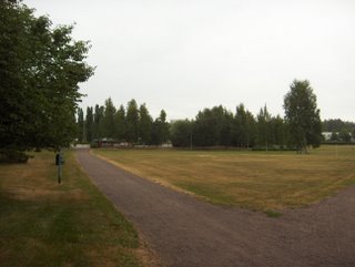 Kuvan tilanteessa satoi vihdoin vettä tälle paikalle, mutta vain heikosti ja vähän aikaa; taivaalla oli sade-, kumpukerros- ja sumupilviä. Sisämaassa satoi paikoin runsaammin ja myös ukkosti. Ennen tätä sadetta kuun 18. päivänä lähellä tätä paikkaa liikkui sateita lännestä Suomen ylle muotoutuneen matalapaineen alueella. Sateet voimistuivat kuitenkin vasta idemmäksi mentyään, kun matalapaineen rintamat kohtasivat Venäjällä säilyneen helteisen ilmamassan. Niinpä lähinnä Itä-Suomessa tuli kuurottaisia sateita. Tämän jälkeen Islannin ja Norjan välistä Välimerelle ulottui korkeapaine ja Suomi jäi itään ja koilliseen siirtyneen matalapaineen länsipuoliselle pohjoistuulen alueelle, jossa vallitsivat lähinnä iltapäivän kumpupilvet. Sää siis viileni; ylimmät lukemat olivat vain n. +20 astetta ja yölämpötilat etenkin sisämaassa vähän alle +10 astetta. Kuun 20. päiväksi ko. korkeapaine siirtyi Suomen ylle ja tuuli tyyntyi. Korkeapaineen länsi - lounaispuolella oli vallinnut jo muutaman päivän ajan erittäin kuuma ilmamassa Länsi-Euroopassa, jossa ilmanpaine-erot olivat tyypillisesti erittäin pieniä. Esim. Saksan ja Puolan tienoilla oli 20. päivänä jopa +35 - +40 asteen helteitä. Edelliseksi päiväksi tuon helleilman pohjoisrajalle syntyi Etelä-Skandinaviaan pieni matalapaine, joka toi vähän kuurottaisia (paikoin ukkostakin) sateita lounaiseen Suomeen jo silloin. Helleilma ei kuitenkaan päässyt Suomeen. Kuivuus ei juurikaan helpottanut ja kuvassa oleva nurmikko ei siis jatkanut kasvuaan. Ainoat vähän vihreät kohdat siinä olivat mm. voikukkia (Taraxacum officinale), piharatamoita (Plantago major) ja rönsyleinikkejä (Ranunculus reptans), jotka sietävät paljon kuivuutta. Kosteilla alueilla kasvukauden etumatka tavanomaiseen näkyi mm. maitohorsman (Epilobium angustifolium) kukinnan loppumisena ja hedelmien aikaisina kypsymisinä; mm. terttuseljan (Sambucus racemosa), tuomen (Prunus padus) ja mustikan (Vaccinium myrtillus) marjat paikoin jo ennen kuun puoltaväliä. Mustikka kuitenkin kärsi monin paikoin kuivuudesta ja joillakin alueilla kasvustot olivat kuivuneet ruskeiksi ja marjasatoa ei muodostunut ollenkaan. Säätilanne: valitse 22.7.2006; Wetter3 A. Wetter3 B.In the situation of the photo it finally rained in this place, but only weakly and for a short time; there were nimbostratus, stratocumulus and stratus clouds in the sky. In inland areas there rained locally more and there were also thunder. Before this rain at the 18th day of the month near this place there was precipitation moving about in the area of a low pressure arrived from the west over Finland. However the precipitation got stronger after it moved more eastwards, as the fronts of the low pressure met the hot air that remained over Russia. Therefore there came showery rain mainly in eastern Finland. After that there reached a high pressure from between Iceland and Norway towards Mediterranean sea and as the low pressure moved to the east and northeast Finland stayed in the area of northerly winds, where prevailed mainly cumulus clouds of the afternoon. So the weather got cooler; the maximum temperatures were only about +20 C and the night temperatures especially in inland areas a little less than +10 C. The high pressure moved over Finland until the 20th day and the wind calmed down. In the western and southwestern side of the high pressure there had been prevailed allready for couple of days a very hot air mass in western Europe, where the air pressure differences were typically very small. For example around Germany and Poland there were hot temperatures even between +35 C and +40 C at the 20th day. Until the previous day at the northern limit of that hot air mass a small low pressure was produced in southern Skandinavia, which brought a little showery rain (locally also thunder) into southwestern Finland allready then. However the hot air didn't arrive in Finland. The drought hardly eased and so the lawn in the picture didn't continue growing. The only little green spots in there were for example Dandelions (Taraxacum officinale), Common Plantains (Plantago major) and Creeping Spearworts (Ranunculus reptans), which can tolerate a lot of drought. In moist areas the advance of the growing season compared to the average was showing for example as ending of the Fireweed (Epilobium angustifolium) blooming and as early ripening of fruits; for example berries of Red Elderberry (Sambucus racemosa), Bird Cherry (Prunus padus) and Blueberry (Vaccinium myrtillus) locally before the middle of the month allready. However Blueberry was harmed in many places by the drought and in some areas its growth had been dried brown and there wasn't formed berry crop at all. Weather condition: choose 22.7.2006; Wetter3 A. Wetter3 B.Helsingin Puistolan säätilasto heinäkuussa 2006 - Weather chart of Puistola, Helsinki in July 2006.Flickr 1 Flickr 2Tehoisa lämpösumma - The Effective Temperature Sum: 851,2
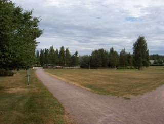
 Edellisen tilanteen jälkeen Britteinsaarten tienoilla ollut korkeapaine vahvistui ja sen myötä luoteis- ja pohjoistuuli valtasi Suomen. Siihen liittyi kylmän rintaman ylitys 14. päivänä ja paikallisia vähäisiä kuurosateita. Tämän jälkeen heikossa - kohtalaisessa pohjoistuulessa vallitsi iltapäivän matalia kumpupilviä ja päivälämpötilat laskivat aikaisemmista helteistä ajankohtaan nähden tavanomaiselle tasolle; n. +21 - +23 astetta. Yölämpötilat pysyivät aluksi n. +10 asteessa, mutta edelliseksi päiväksi Suomen ylle lounais - koillissuuntaisesti muotoutunut korkeapaineen selänne sai tuulet tyyntymään ja sen myötä viime yö oli viileä; +8,1 astetta. Päivälämpötila sen sijaan oli taas hellerajalla; +24,6 astetta. Helteissä lämmennyt Suomenlahti (n. +20 asteista ja rannoilla aluksi pari astetta yli) heikensi merituulen jo lähes olemattomiin. Sen vuoksi kuvan tilanteessa (kylmä rintama ja kehittyvä matalapaine lähestyivät lännestä) olleet kumpupilvet esiintyivät nyt osaksi merenkin yllä. Samasta syystä sisämaan ja etelärannikon iltapäivien lämpötiloissa ei ollut merkittäviä eroja, mutta yöt olivat rannikolla paikoin lämpimämpiä; jopa n. +15 astetta ulkomeren saarilla. Pienten järvien vedet viilenivät nyt sään takia aikaisemmista jopa yli +25 asteen lukemista lähelle +20 astetta. Em. sateet eivät tuoneet helpotusta kuivuuteen, vaan se paheni edelleen. Nyt etenkin kallioisilla mäillä kuivuuden aiheuttama lehtipuuruska alkoi olla paikoin totaalista ja osa pienten lehtipuiden ja taimien lehdistä oli kuivunut korpuksi suoraan vihreästä. Kasvu alkoi tukahtua hieman jo normaalisti melko kosteillakin alueilla. Esim. lähteisillä paikoilla, alavilla rannoilla ja soilla kasvun määrä vastasi silti vielä hyvin tehoisan lämpösumman arvoa, joka oli nyt ajankohtaan nähden yli kaksi viikkoa etuajassa. Kuivuus näkyi nyt kuitenkin jo vesistöissäkin, kun niiden pinnat olivat laskeneet useita senttejä alle tavanomaisten tasojen. Säätilanne: valitse 17.7.2006; Wetter3 A. Wetter3 B.After the previous situation a high pressure around British Isles got stronger and due to that northwesterly - northerly winds took over Finland. There was associated a crossing of a cold front at the 14th day and local minor showers. After that in the weak - moderate northerly wind there prevailed flat cumulus clouds of the afternoon and temperatures dropped from earlier heatwave to an average level; about +21 C to +23 C. The night temperatures remained at about +10 C at first, but until the previous day there formed a ridge of high pressure over Finland along the direction of southwest - northeast, which got the winds to calm down and due to that the last night was cool; +8,1 C. As opposed to that the aftenoon temperature was again at the limit (+25 C in Finland) of the heatwave; +24,6 C. The Gulf Of Finland warmed up (about +20 C and by the coastal waters couple of degrees more at first) due to the heatwaves weakened the sea breeze almost into nonexsistent. Therefore the cumulus clouds in the situation (a coldfront and an evolving low pressure approached from the west) of the picture appeared now partly over the sea as well. Due to the same reason there wasn't notable differences in the afternoon temperatures between inland areas and the southern coast, but the nights were locally warmer by the coast; even about +15 C in open water islands. Due to the weather the waters of small lakes cooled down now from the earlier even over +25 C readings near +20 C. The rains mentioned earlier didn't ease the drought, but it got worse further more. Now especially in rocky hills fall colours in broadleaf trees caused by the drought were locally total and a part of leaves of small trees and sprouts had been dried up straight from green into a crispy stage. The growth started allready to suffocate a little in normally rather moist areas as well. Though, for example in areas with springs in the ground, in flat coastal areas and in swamps the amount of the growth was yet finely equal to the value of the effective temperature sum, which was now more than two weeks ahead of schedule as compared to the time of the year. However the drought appeared now allready in water areas as well, as their surfaces had been dropped several centimetres below normal levels. Weather condition: choose 17.7.2006; Wetter3 A. Wetter3 B.Helsingin Puistolan säätilasto heinäkuussa 2006 - Weather chart of Puistola, Helsinki in July 2006.Flickr 1 Flickr 2Tehoisa lämpösumma - The Effective Temperature Sum: 793,6
 Edellisen kuvan jälkeen 10. päivänä Etelä- ja Keski-Suomen sisämaassa ukkosti paikoin ankarasti. Esim. itäisessä Suomessa tuli paikoin jopa munan kokoisia rakeita ja ukkospuuskat / trombit kaatoivat metsää. Tämän aiheutti Skotlannin tienoilta Lapin yli siirtynyt matalapaine ja sen rintamasysteemi, joka ylitti Suomen lännestä itään. Etelärannikko jäi tässäkin tilanteessa melkein kokonaan ilman sateita tai niitä tuli hyvin paikallisesti. Kuvausalueella kuivuus jatkui ja paheni vääjäämättömästi, mutta sisämaassakin kuivuuteen tuli helpotusta vain paikallisesti. Islannin tienoilla ja siitä itään oli parin viime päivän aikana voimakas matalapaine, joka toi edellisenä päivänä taas yhden rintaman Suomen yli, mutta senkään sateet eivät osuneet kuin harvoille paikoille. Kuvauspäivänä Etelä-Suomi oli kahden rintamavyöhykkeen välissä, jossa lännestä lähestynyt toinen rintama toi kuvan tapaan hahtuva-, kumpukerros ja untuvapilviä lauttoina. Niiden seassa oli konvektiivisempia kumpupilviä etenkin sisämaassa, mutta ei juuri sadetta. Ilmamassan kuivuuden takia (ei utua) pilvien muodot näkyivät hyvin. Lämpötilat pysyivät helteisinä koko ajan edellisen kuvan jälkeen; vähän yli +25 astetta päivittäin em. rintamista huolimatta, sillä välittömästi Suomen itä- ja kaakkoispuolelle Atlantilta itään ulottuvan korkeapaineen kielekkeen alueelle jäi hyvin kuumaa ilmaa. Siinä lämpötilat olivat paikoin jopa yli +35 astetta. Yötkin olivat lämpimiä (selvästi yli +15 astetta) Etelä-Suomessa aikaisempaa runsaamman pilvisyyden ja ajoittain voimistuneiden tuulten ansiosta. Ko. päivän yö oli viileä selkeän ja tyynen sään takia; +11,0 astetta. Lämmenneiden vesien äärellä yöt olivat muita alueita lämpimämpiä. Pitkään lämpiminä olleissa vesistöissä alkoi esiintyä paikoin runsaasti sinilevää, joka heikensi uintiolosuhteita. Kosteilla alueilla kasvukausi oli nyt jopa yli kaksi viikkoa edellä normaalista; maitohorsman (Epilobium angustifolium) kukinta oli päättymässä ja tyypillinen elokuun kukkija pietaryrtti (Tanacetum vulgare) oli aloittanut kukinnan. Kuivilla kasvupaikoilla isotkin puut alkoivat kellastua ja pienet taimet olivat kuivuneet osittain kokonaan. Säätilanne: valitse 13.7.2006; Wetter3 A. Wetter3 B.After the previous photo there was locally severe thunder in southern and central Finland. For example in eastern Finland there came locally even egg sized hail and thunder gusts / trombs (a weak form of tornado called this way in Europe) fell down forests. This was caused by a low pressure moved from around Scotland across Lapland and the frontal system associated with it, which crossed Finland from the west to the east. The southern coast remained also in this situation allmost without rain or there was rain very locally. In the photoshooting scene the drought continued and got worse irrevocably, but also in inland areas there was relief to the drought only locally. Around Island and eastwards from it there was a strong low pressure during couple of last days, which brought again one front across Finland in the previous day, but even the precipitation of that reached only few places in southern Finland. In the day in question southern Finland was between two fronts, where the other front approached from the west brought stratocumulus, altocumulus and cirrus clouds as layers in the way of the picture. Among them there were more convective cumulus clouds especially in inland areas, but hardly any rain. Due to the dry airmass (no haze) shapes of the clouds appeared finely. The temperatures remained hot all the time since the previous picture; a little over +25 C daily despite the mentioned fronts, because immediately in the eastern and southestrn side of Finland in the area of a high pressure strip reached eastwards from Atlantic there remained very hot air. Temperatures were there locally even more than +35 C. Also nights were warm (clearly over +15 C) in southern Finland thanks to the more plentyfull cloudyness than before and occasionally strengthened winds. The night of this day was cool, because of a clear and calm weather; +11,0 C. Beside warmed up water areas the nights were warmer than elsewhere. In the waters stayed long time warm there started to appear locally plenty of blue-green algae, which worsened swimming conditions. In moist areas the growing season was now even more than two weeks ahead of normal; the blooming of Fireweed (Epilobium angustifolium) was ending and a typical bloomer of august Common Tansy (Tanacetum vulgare) had been started the blooming. In dry localitys even big trees started to turn yellow and small young plants had been dried up partly completely. Weather condition: choose 13.7.2006; Wetter3 A. Wetter3 B.Helsingin Puistolan säätilasto heinäkuussa 2006 - Weather chart of Puistola, Helsinki in July 2006.Flickr 1 Flickr 2Tehoisa lämpösumma - The Effective Temperature Sum: 739,2
 Kesän viides helleaalto oli tässä vaiheessa huipentunut edellisenä päivänä. Tällöin laajalti koko eteläisessä Suomessa päivän ylimmät lämpötilat olivat n. +30 - +32 astetta. Yötkin olivat nyt lämmenneet, vaikka lounaistuuli oli edelleen heikkoa ja pilvisyys hyvin vähäistä; pari viime yötä vietettiin n. +15 asteen lämmössä. Kuvauspäiväksi lännestä saapui kylmä rintama, kun pohjoisella Atlantilla kehittyneet useat matalapaineet alkoivat kierrättää voimakkaammin viileää ilmaa Britteinsaarten yli Norjaan ja Ruotsiin. Ko. rintama jäi ko. päiväksi Suomen ylle erottaen heti Suomen kaakkoispuolelle jopa +35 asteen hellettä. Viilenemisestä huolimatta Etelä-Suomessa oli ko. päivänä edelleen +25 - +30 asteen lukemia. Rintama toi ko. päivänä kesän tähän mennessä ankarimmat ukkoset, mutta niitä esiintyi vain paikoin lähinnä sisämaassa Itä-Suomi painotteisesti ja etelärannikko jäi taas melkein kokonaan ilman sateita; kuvausalueella ei satanut yhtään. Kuvassa taivaanrannassa nähdään itse asiassa erään ukkospilven yläosaa; ko. pilvi liikkui Suomenlahden yli koilliseen ja se ohitti siten reilusti Helsingin ja samalla tämän paikan. Sateettomilla alueilla rintamapilvisyytenä oli muution vain etenkin untuva-, hahtuva- ja kumpukerrospilviä. Utu oli lisääntynyt ennen rintaman ylitystä. Sateettomilla alueilla kuivuus nosti nyt huolestuneita ajatuksia maanviljelijöiden mieleen; satonäkymät jatkoivat heikkenemistään. Myös osa puistojen ja puutarhojen herkimmistä kasveista (puiden taimet, perennat ja pienet pensaat) olivat jo vaurioituneet peruuttamattomasti jonkin verran. Yhä suurempi osa nurmikoista alkoi olla kuvan nurmikon tapaan ruskeita. Helteen aikana lomailijoiden uintiolosuhteen olivat kuitenkin erinomaiset; pienet järvet olivat jopa +25 - +30 asteisia ja kaikki uimarannat olivat hyvin täynnä ihmisiä. Säätilanne: valitse 9.7.2006; Wetter3 A. Wetter3 B.At this stage the fifth heatwave of the summer had been peaked in the previous day. At that time widely around southern Finland the maximum temperatures of the day were about +30 C to +32 C. Also nights had now been warmed up, allthough southwesterly winds were further weak and the cloudyness was very minor; last couple of nights were spend in the temperatures of about +15 C. There arrived a cold front from the west until the photoshooting day, as many low pressures evolved over northern Atlantic started to circulate cooler air more strongly across British Isles into Norway and Sweden. This front stayed over Finland during this day dividing immediately to the southeastern side of Finland hot air of even +35 C temperatures. Despite the cooling there were further +25 C to +30 C readings in southern Finland during this day. The front brought in this day the severest thunderstorms of the summer so far, but those appeared only locally mainly in inland areas emphasizing to the eastern Finland and the southern coast remained again allmost without rain; there rained nothing in the photoshooting area. In the picture in the horizon we see actually upper part of one thundercloud / cumulonimbus cloud; this cloud moved across The Gulf Of Finland to the northeast and so it passed widely Helsinki and at the same time this scene. In the areas without rain the frontal cloudyness contained otherwise especially cirrus, altocumulus and stratocumulus clouds only. Haze had been increased before the crossing of the front. In the rainless areas there rised now worrying thoughts in the minds of farmers caused by the drought; crop outlooks were decreasing further. Also part of the most sensitive plants (young trees, perennials and small shrubs) in parks and gardens had allready been damaged irreversible in some degree. Even larger amount of lawns started to become brown in the way of the one in the picture. However the swimming conditions of holidaymakers were excellent during the heatwave; the waters in small lakes were even +25 C to +30 C warm and all beaches were very full of people. Weather condition: choose 9.7.2006; Wetter3 A. Wetter3 B.Helsingin Puistolan säätilasto heinäkuussa 2006 - Weather chart of Puistola, Helsinki in July 2006.Flickr 1 Flickr 2Tehoisa lämpösumma - The Effective Temperature Sum: 671,7
 Edelllisen tilanteen kylmän rintaman ylityksen jälkeen lännestä siirtyi heti uusi korkeapaine Etelä-Suomen ylle ja kuvauspäiväksi se yhdistyi Suomen eteläpuolella olleeseen korkeapaineeseen. Tämän vuoksi sää jatkui edelleen hyvin vähäpilvisenä (vain paikoin ja ajoittain oli untuvapilviä ja sisämaassa kumpupilviä) ja helle palasi uudelleen lounaasta käsin täksi päiväksi. Hyvin kuumaa ilmamassaa oli tässä vaiheessa Saksan ja Puolan tienoilla; jopa n. +35 asteen lukemia esiintyi. Meri oli lämmennyt nyt yli +20 asteen rantavesissä ja ulapalla lähelle +20 astetta. Tämän vuoksi merituuli oli enää paikallista, heikkoa ja ulottui vain kapealle rantavyöhykkeelle (alle 10 km sisämaahan rantaviivasta). Niinpä iltapäivän lämpötilojen erot olivat sisämaan ja etelärannikon välillä vain parisen astetta ja ko. päivänä etelärannikollakin oli selvästi hellettä ylimmän lukeman oltua +27,2 astetta. Sen sijaan yölämpötilat olivat paikoin sisämaata korkeammat lämmenneen meren vuoksi. Tämän ansiosta etelärannikon kasvukauden vaiheen viive Etelä-Suomen sisämaahan verrattuna oli yhä vähenemässä. Tätä ei kuitenkaan helposti enää huomannut, koska yhtäältä kasvien kehitys alkoi olla kasvukauden jälkipuoliskolle tyypillisesti huomaamatonta (mm. loppuun kasvaneiden versojen puutumista) ja toisaalta kuivuuden aiheuttamat erot kasvussa olivat paikallisesti jo hyvin vaihtelevia kaikkialla Etelä-Suomessa. Säätilanne: valitse 6.7.2006; Wetter3 A. Wetter3 B.After the crossing of the cold front in the previous situation there moved immediately a new high pressure from the west over southern Finland and until the photoshooting day it fused into the high pressure that was in the southern side of Finland. Therefore the weather continued further very little cloudy (only locally and occasionally there were cirrus clouds and cumulus clouds in inland areas) and the heatwave returned again until this day from the southwest. There was very hot air mass at this stage around Germany and Poland; even about +35 C readings appeared. The sea had been warmed up over +20 C on the waters by the coast and in the open waters near +20 C. Therefore the sea breeze was local, weak and reached only into narrow coastal zone (less than 10 kilometres towards inland areas from the coastal line) any more. Therefore the differences of the afternoon temperatures between inland and coastal areas were only couple of degrees and in the day in question there was clearly hot weather also by the southern coast as the maximum reading was +27,2 C. As opposed to that the night temperatures were locally higher than in inland areas due to the warmed up sea. Thanks to that the delay of the growing season's phase by the southern coast compared to the inland areas of southern Finland was decreasing further. However this wasn't easily observed any more, because in one hand evolving of the plants started to be inconspicuous (for example becoming woody of shoots grown in full size) typical of the latter part of the growing season and on the other hand the differences in growth caused by the drought were allready locally very variable all around southern Finland. Weather condition: choose 6.7.2006; Wetter3 A. Wetter3 B.Helsingin Puistolan säätilasto heinäkuussa 2006 - Weather chart of Puistola, Helsinki in July 2006.Flickr 1 Flickr 2Tehoisa lämpösumma - The Effective Temperature Sum: 615,5
 Kesän neljäs helleaalto oli tässä tilanteessa päättymässä, kun Etelä-Suomen yllä ollut korkeapaine oli heikentynyt ja siirtynyt etelämmäksi. Sen takia jo muutamia päiviä Norjan länsirannikon lähellä sijainnut rintamavyöhyke alkoi ylittää Suomea luoteesta. Samassa yhteydessä Lappiin muodostui uusi matalapaine, joka voimisti ko. päivänä länsituulia. Ko. kylmän rintaman ylitys näkyi kuvauspaikalla aluksi untuvapilvinä, mutta kuvaustilanteessa koko taivaan peitti harso- ja verhopilvet rintaman suuntaisina kilpinä. Paikoin oli hahtuvapilviä (kuten kuvassa taivaanrannassa) ja kumpukerrospilviä. Aurinko pääsi kuitenkin kuultamaan melkein koko ajan pilvien läpi. Vain sisämaassa kehittyi paikoin kuuro- ja ukkospilviä, mutta etelärannikolla jatkui käytännössä sateeton sää. Rintaman etupuolella oli vielä hellettä; kuvausalueella oli +27,3 astetta ylimmillään. Kuvan nurmikon kasvu oli siis tyrehtynyt ja siten sen leikkaustarve loppui. Ennen tätä sitä leikattiin ko. kasvukaudella n. 5 kertaa (eri osia leikattiin eri tahtiin). Kuivan sään vaikutukset näkyivät tässä vaiheessa myös kasvun eroina kosteiden ja kuivien alueiden kesken, koska kuivuus yhtäältä hidasti kasvua ja toisaalta kosteilla alueilla suuri lämmön määrä näkyi vielä nopeana kasvuna. Niinpä hedelmien kehityksessä oli nyt esim. kotipihlajan (Sorbus aucuparia) tai omenapuiden (Malus domestica) kohdalla selviä eroja eri kasvupaikkojen kesken. Alla mainitun tehoisan lämpösumman kasvun tilannetta kuvaava aspekti alkoi siis vääristyä yhä enemmän kuivilla kasvupaikoilla jääden jälkeen summan paljastamasta arvosta. Säätilanne: valitse 4.7.2006; Wetter3 A. Wetter3 B.The fourth heatwave of the summer was ending at this stage, as the high pressure over southern Finland had been weakened and moved more to the south. Due to that a frontal zone situated allready for couple of days near the western coast of Norway started to cross Finland from the northwest. At the same time there formed a new low pressure over Lapland, which strengthened westerly winds during this day. The crossing of this cold front in question was apprearing in the photoshooting scene at first as cirrus clouds, but in the photoshooting situation the sky was completely covered by cirrostratus and altostratus clouds as shields along the direction of the front. Locally there were altocumulus clouds (as in the horizon in the photo) and stratocumulus clouds. However the sun was able to glow through the clouds allmost all the time. Only in inland areas there formed locally shower- and thunderclouds (cumulonimbus clouds), but by the southern coast there continued rainless weather in practice. There was yet hot weather in the foreside of the front; in the photoshooting area there was +27,3 C at highest. So the growth of the lawn in the picture was ended and therefore the need of mowing it stopped. Before this it was mowed about 5 times (different parts were mowed in various intervalls) during this growing season. Influences of the dry weather were showing at this stage also as differences of growth between dry and moist areas, because the drought in one hand slowed down the growth and on the other hand the big amount of warmth was yet showing as a fast rate of growth in moist areas. Therefore in the progress of fruits for example concerning Rowan / European Mountain Ash (Sorbus aucuparia) or Apple trees (Malus domestica) there were clear differences between different localitys. So the aspect of the growing's stage described by the value of the effective temperature sum mentioned underneath started to become distorted in dry localitys ever more as leaving behind from the value revealed by the sum. Weather condition: choose 4.7.2006; Wetter3 A. Wetter3 B.Helsingin Puistolan säätilasto heinäkuussa 2006 - Weather chart of Puistola, Helsinki in July 2006.Flickr 1 Flickr 2Tehoisa lämpösumma - The Effective Temperature Sum: 584,6
 Edellisen kuvan jälkeen Etelä-Suomen yllä ollut pieni matalapaine siirtyi nopeasti itään heti seuraavana päivänä ja korkeapaine alkoi vaikuttamaan lännestä käsin. Sitten korkeapaine siirtyi eteläisen Suomen ylle ja jäi suunnilleen sijoilleen tähän päivään asti. Korkeapaine toi mukanaan kesän neljännen helleaallon (hellealue ulottui Espanjaan asti), jossa ko. päivänä mitattiin heinäkuun tähän mennessä korkeimmat lukemat; ko. paikalla +26,6 astetta ja sisämaassa lähes +30 astetta. Korkeapaineen takia tuulet olivat 30.6. lähtien yleisesti hyvin heikkoja ja tyyniäkin, mutta merituuli vaikutti ajoittain ja alensi siten tilapäisesti esim. tällä alueella tämän kuun 1. päivän ylintä lämpötilaa. Lämmennyt Suomenlahti (rantavesien lämpötilat olivat n. +20 astetta) ja yli +20 asteen lämmenneet pienetkin järvet vaikuttivat toisaalta yölämpötiloihin kohottamalla niitä muutamalla asteella paikallisesti ja ajallisesti vaihdellen. Ilmamassa oli koko ajan melko kuivaa (taivaan voimakas sinisyys) ja kumpupilvien muodostuminen oli siten hyvin vähäistä eteläisessä Suomessa. Korkeapaineen itäpuolella Venäjälle virtasi hyvin viileää ilmaa pohjoisesta ja Suomen itärajan lähellä ko. ilmamassaa rajasi vaihteleva rintamasysteemi. Sen pilvisyyttä esiintyi ajoittain kuvan tapaan untuvapilvinä Etelä-Suomessa. Ajoittain oli myös harso-, verho- ja hahtuvapilviäkin, mutta vain vähän; ne vaikuttivat silti esim. kohottamalla yölämpötiloja paikallisesti. Sateettoman ja kuuman sään vuoksi kuivuus paheni entisestään ja kuvan nurmikolle se tiesi tässä vaiheessa kasvun tyrehtymistä jo kokonaan ja värin muuttumista melkein kokonaan ruskeaksi. Myös kivikkoisten mäkien lehtipuut ja -pensaat muuttuivat paikoin hyvin näkyvästi keltaisiksi kuin syksyllä. Kosteilla alueilla kasvukausi eteni silti vielä nopeasti ja etumatka tavanomaiseen aikatauluun oli jo n. kaksi viikkoa. Tämän vuoksi heinäkuun tyypillinen kukkija maitohorsma (Epilobium angustifolium) oli jo nyt keskimäärin täydessä kukassa. Säätilanne: valitse 3.7.2006; Wetter3 A. Wetter3 B.After the previous photo the lowpressure over southern Finland moved quickly to the east immediately the next day and a high pressure started to affect from the west. Then the high pressure moved over southern Finland and remained approximately in place until this day. The high pressure brought the fourth heatwave (the hot area reached all the way to Spain) of the summer with it, where during this day there was measured the highest readings of july so far; in this area +26,6 C and in inland areas allmost +30 C. Due to the high pressure the winds were commonly very weak and also calm from 30th of june onwards, but the sea breeze affected occasionally and it lowered down temporarily for example in this area the maximum temperature of the 1st day of this month. The warmed up The Gulf Of Finland (Temperatures of coastal waters were about +20 C) and also small lakes warmed up over +20 C had an effect on the other had to the night temperatures as rising the readings couple of degrees varying locally and temporally. The air mass was all the time rather dry (strong blueness of the sky) and therefore the formation of cumulus clouds was very minor in southern Finland. In the eastern side of the high pressure there flowed very cool air into Russia from the north. Near the eastern border of Finland this air mass was bordered by a variable frontal zone. Its cloudyness appeared occasionally as cirrus clouds in southern Finland in the way of the picture. Occasionally there were also cirrostratus, altostratus and even altocumulus clouds, but only small amounts; they affected though as rising up the night temperatures locally. Due to the rainless and hot weather the drought worsened further and it meant at this stage to the lawn in the picture a suffocation of the growth allready completely and a change of colour into allmost completely brown. Also the broadleave trees and shrubs in rocky hills turned locally very visibly yellow like in autumn. In moist areas though the growing season progressed yet fast and the advance to the average time table was now allready about two weeks. Therefore typical bloomer of July Fireweed (Epilobium angustifolium) was allready now approximately in full bloom. Weather condition: choose 3.7.2006; Wetter3 A. Wetter3 B.Helsingin Puistolan säätilasto heinäkuussa 2006 - Weather chart of Puistola, Helsinki in July 2006.Flickr 1 Flickr 2Tehoisa lämpösumma - The Effective Temperature Sum: 568,7