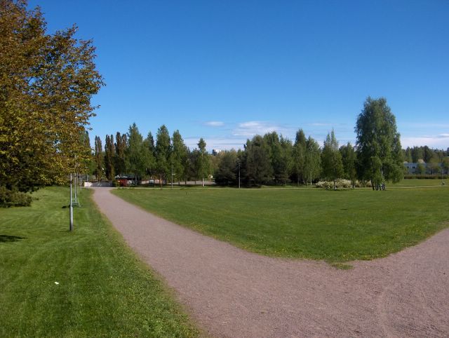
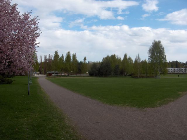
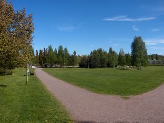
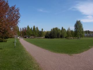
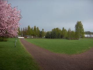
Edelliseen kuvaan verrattuna tässä jatkui samanlainen säätyyppi; iltapäivällä sisämaassa oli sadekuuroja ja yöllä sateiden vähennyttyä oli etenkin sisämaassa monin paikoin hallaa. Viileä ilmamassa vallitsi siis edelleen ja päivälämpötila jäi +16,8 asteeseen. Tässä ja edellisessä kuvassa nähdään lähes selkeää taivasta, mutta itse asiassa molemmissa tilanteissa sisämaan kuuropilvet olivat hyvin lähellä kuvaajan selän takana ja vasemmalla puolella. Merituuli vaikutti sen verran, että meren ylle ei syntynyt kuuropilviä. Tässä kuvassa nähdään parhaiten Virossa olleiden kuuropilvien yläosia meren toisella puolella taivaanrannassa. Tässä vaiheessa etelästä oli lähestymässä uusi voimistuva matalapaine, jonka myötä etelästä meren yli nousi illalla runsasta pilvisyyttä; mm. untuva-, harso-, verho- ja kumpukerrospilviä. Samalla itätuuli voimistui ja seuraavana yönä ei siten ollut enää hallaa; edellinen yö jäi kevään viimeiseksi hallayöksi. Viileästä säästä huolimatta aurinko oli näin tokokuun lopussa niin korkealla, että vallinneessa heikossa tuulessa n. +15 astettakin tuntui miellyttävän lämpimältä. Päivät olivat myös jo niin pitkiä, että yöt eivät enää pimenneet kokonaan toukokuun alun jälkeen ja 30. päivänä aurinko nousi jo heti aamu neljän jälkeen ja laski illalla vasta melkein puoli yhdeltätoista. Selvästi kesän makua oli siis tällä hetkellä ilmassa, vaikka vielä oli melko viileää. Suomenlahden vesi pysyi kuitenkin koko toukokuun ajan korkeintaan vain n. +10 asteessa ja toukokuun alun kesäisen lämpöaallon jälkeen pienet vesistötkään eivät olleet juuri sen lämpimämpiä (lämpöaallossa ehtivät olla kuitenkin lähes +20 astetta). Säätilanne: valitse 31.5.2006; Wetter3 A. Wetter3 B.
As compared to the previous picture here was continuing the same kind of weather type; there were showers in the afternoon in inland areas and at night as the precipitation eased away there was ground frost in many places especially in inland areas. So, the cool air mass continued further and the afternoon temperature stayed at +16,8 C. In this and the previous picture we see allmost clear skies, but actually in the both situations cumulonimbus clouds / shower clouds of the inland areas were near the photographer in the backside and on the leftside. The sea breeze was affecting in such a way, that there weren't cumulonimbus clouds forming over the sea. In this picture we see in the best way the uppersides of the cumulonimbus clouds in Estonia on the other side of the sea on the horizon. At this stage there was a new and strengthening low pressure nearing from the south, which brought plentyfull cloudyness in the evening across the sea from the south; for example cirrus, cirrostratus, altostratus and stratocumulus clouds. An easterly wind picked up at the same time and therefore there wasn't ground frost anymore at the next night; the previous night remained the last night with ground frost this spring. Despite the cool weather the sun was so high at this time of may, that in the prevailed weak wind even about +15 C felt pleasently warm. The days were also so long, that nights didn't darkened completely anymore since the beginning of may and at the 30th day the sun rose allready immediately after 4 am and it was setting as late as allmost half past ten in the evening. So, there was clearly summery feel in the air at this time, allthough it was yet rather cool. However the water of The Gulf Of Finland stayed at highest only about +10 C during all may and after the summery warm weather period in early may small waters weren't much that warmer either (however they had time to be allmost +20 C in the warm period) Weather condition: choose 31.5.2006; Wetter3 A. Wetter3 B.
Helsingin Puistolan säätilasto toukokuussa 2006 - Weather chart of Puistola, Helsinki in May 2006.Flickr 1 Flickr 2
Tehoisa lämpösumma - The Effective Temperature Sum: 194,4 
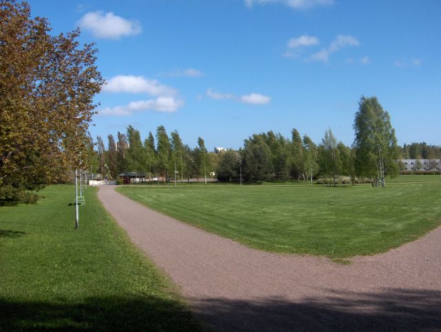
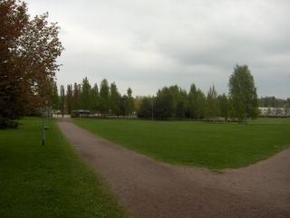
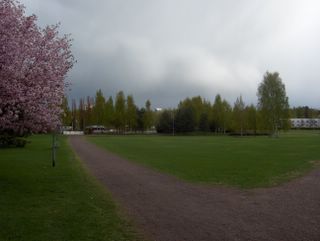
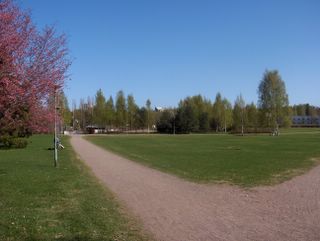
Edellisen kuvan jälkeen silloinen matalapaine oli edelleen Suomen yllä 27. päivään saakka; seurauksena oli ajoittain kuurottaisia sateita ympäri vuorokauden. Sitten 28. päivän aikana sekä lännestä että kaakosta toiset matalapaineet siirtyivät lähemmäksi Suomea ja yhtyivät yhdeksi suureksi matalapaineeksi Suomen ylle edelliseksi ja täksi päiväksi; tällöin kuurosateet olivat vähentyneet hieman ja keskittyivät nyt enemmän sisämaahan ja kummankin vuorokauden iltapäiviin. Ilmamassa oli koko ajan kuitenkin tavanomaista viileämpää ja edellisen kuvan jälkeen lämpötila oli ylimmillään +15,1 astetta 25. päivänä. Öisin oli aluksi hallatonta tuulten ja pilvien ansiosta, mutta 27. päivän yöstä lähtien tuulet tyyntyivät ja sateet olivat öisin vähäisiä, jolloin vähäpilvisillä alueilla etenkin sisämaassa oli hallaa. Kasvukausi eteni siis edelleen hitaasti (oli silti vielä n. tavanomaisessa aikataulussa), joka havaitaan mm. tuosta kuvan rusokirsikasta (Prunus sargentii); sen kevätväri oli säilynyt osittain näinkin monen päivän jälkeen. Taustan koivuissa (Betula sp.) oli jo tosin melko kesäinen vehreys ja isoimmasta koivusta vähän vasemmalle nähdään ko. ajankohdan tyypillinen kukkiva pensas; norjanangervo (Spiraea "Grefsheim"). Säätilanne: valitse 30.5.2006; Wetter3 A. Wetter3 B.
After the previous photo the low pressure of that time was further over Finland until the 27th day; that caused occasional showery rain night and day. Then during the 28th day other low pressures both from the west and southeast moved nearer to Finland and fused together into one big low pressure over Finland for the previous and this day; this time showers were decreased a little and they concentrated more into inland areas and in the afternoons of the both days. However the air mass was all the time cooler than the average and after the previous picture the temperature was at highest +15,1 C in the 25th day. At nights there wasn't ground frost at first due to the clouds and the winds, but since the night of the 27th day the winds calmed down and the precipitation was small at nights, so therefore in the places of minor clouds especially in inland areas there was ground frost. So, the growing season progressed further in a slowly pace (it was yet about in the average timetable though), which is observed from that Sargent Cherry (Prunus sargentii) in the picture; the spring colour of it had been remained partly even after so many days. There were rather summery green tone in the birches (Betula sp.) at the background though and a little left from the biggest birch we see a typical blossoming shrub of this season; Grefsheim Spiraea (Spiraea "Grefsheim"). Weather condition: choose 30.5.2006; Wetter3 A. Wetter3 B.
Helsingin Puistolan säätilasto toukokuussa 2006 - Weather chart of Puistola, Helsinki in May 2006.Flickr 1 Flickr 2
Tehoisa lämpösumma - The Effective Temperature Sum: 187,3

Tässä kuvassa nähdään viimeinkin myös tuon nurmikon ensimmäinen leikkuukerta. Leikkuu oli tapahtunut vain parisen tuntia ennen ko. kuvan ottoa. Ensimmäiset nurmikot oli leikattu näillä seuduilla kesäisen lämpimän sääjakson päättyessä n. 12. - 15. päivinä. Tässä vaiheessa edellisen päivän matalapaine oli nyt Suomen yllä ja sen eteläpuolella Etelä-Suomessa vallitsi hyvin voimakas länsituuli. Kuvassa puiden nähdään taipuneen tuulen voimasta selvästi. Jo melko isoiksi kasvaneet puiden lehdet pitivät kovaa suhinaa tuulenpuuskissa. Ilmamassa viilentyi tuulen myötä niin, että päivälämpötila oli iltapäivän ajoittaisesta pilvien rakoilusta huolimatta vain +10,5 astetta. Kuvan tilanteessa edellisen yön ja aamun sadekuurot pilvineen olivat siirtyneet sisämaan puolelle ja kovassa tuulessa seilasi nyt nopeasti repalaisia kumpupilviä. Pilvisyys kuitenkin lisääntyi taas illalla; mm. kumpukerros- ja sumupilvilauttoja. Tuuli heikkeni samalla, mutta seuraava yö pysyi pilvien takia hallattomana viileästä ilmamassasta huolimatta. Säätilanne: valitse 24.5.2006; Wetter3 A. Wetter3 B.
In this picture we see finally the first mowing time of that lawn. The mowing had been happened only couple of hours earlier before this photo was taken. The first lawns had been cut in this area around 12th to 15th days, when the summery weather period was ending. At this stage the low pressure of the previous day was now over Finland and in the southern side of that there prevailed a very strong westerly wind in southern Finland. In the picture we see the trees bended clearly by the force of the wind. The leaves grown allready rather big in size in the trees were whirring loudly in the wind's gusts. The airmass got cool in such a way due to the wind, that the daytime temperature was only +10,5 C despite the occasionally broken cloudyness of the afternoon. In the situation of the photo showers of the last night and morning with their clouds had been moved to the inland areas and in the strong wind there were now floating fast ragged cumulus clouds. However the cloudyness increased again in the evening; for example layers of stratus and stratocumulus clouds. The wind eased at the same time, but due to the clouds there wasn't ground frost at the next night despite the cool air mass. Weather condition: choose 24.5.2006; Wetter3 A. Wetter3 B.
Helsingin Puistolan säätilasto toukokuussa 2006 - Weather chart of Puistola, Helsinki in May 2006.Flickr 1 Flickr 2
Tehoisa lämpösumma - The Effective Temperature Sum: 162,5
Britteinsaarilla ja pohjoisella Atlantilla oli edelleen laaja matalapaineen alue useine keskuksineen. Edellisen päivän korkeapaineen selänne oli täksi päiväksi väistynyt itään, kun yksi matalapaineen keskus liikkui Etelä-Suomen länsipuolelle Britteinsaarilta. Sen okluusiorintama toi melko runsaan kuurottaisen sateen alueen suurimpaan osaan Suomea ja kuvauspaikallakin satoi iltapäivän aikana yli 10mm. Kuvassa sadealue oli juuri ohittanut paikan ja taivaalla nähdään tyypillisesti paksuja sumupilviä sadealueen takareunassa. Osa pilvistä oli myös kumpukerrospilviä. Pilvien ja sateen myötä päivälämpötila jäi tällä alueella +13,5 asteeseen. Tuulet olivat ajoittain kohtalaisia; ennen sadetta tuuli etelästä ja sen jälkeen tuulet kääntyivät heikenneinä lounaaseen ja länteen. Yötä kohti länsituuli voimistui uudestaan. Kuvassa keskellä mäntyjen takana nähdään hyvin hopeapajun (tai nykyään hopeasalava) (Salix alba "Sibirica") keltaista kukintaa. Kasvukauden etenemistä hidasti 14. - 20. päivinä huomattavasti viileä jakso. Ennen ko. kylmää jaksoa kehittynyt kasvukauden 1 - 2 viikon etumatka tavanomaiseen oli tässä vaiheessa kutistunut lähes tavanomaiseksi. Etelä-Suomen sisämaassa etumatkaa oli vielä muutamia päiviä jäljellä. Säätilanne: valitse 23.5.2006; Wetter3 A. Wetter3 B.
In British Isles and northern Atlantic there was further a large area of low pressure with many centers. The ridge of high pressure during the previous day had been moved to the east until this day, as one low pressure center moved to the western side of southern Finland from the British Isles. A occluded front associated with it brought rather heavy showery precipitation area into most of Finland and also in the photoshooting scene it rained over 10 millimetres. In the picture the precipitation area had just been crossed the scene and in the sky we see typically a thick layer of stratus clouds in the backside of the precipitation area. Part of the clouds were also stratocumulus clouds. Due to the clouds and rain the daytime temperature stayed at +13,5 C in this region. Winds were occasionally moderate; before the rain winds blowed from the south and after that they turned to the southwest and west in weakened stage. Towards the night westerly wind picked up again. In the middle of the picture behind the pine trees we see finely yellow blooming of White Willow (Salix alba "Sibirica"). The progression of the growing season was slowed down signifigantly by the cool period between the 14th and 20th days. The growing season's 1 - 2 week lead compared to the average, which was formed before that cold period was at this stage narrowed allmost into average. In the inland areas of southern Finland there was yet a couple of days lead left. Weather condition: choose 23.5.2006; Wetter3 A. Wetter3 B.
Helsingin Puistolan säätilasto toukokuussa 2006 - Weather chart of Puistola, Helsinki in May 2006.Flickr 1 Flickr 2
Tehoisa lämpösumma - The Effective Temperature Sum: 158,8
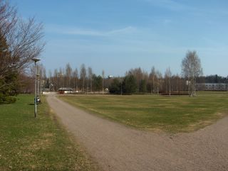
Edellisen kuvan jälkeen kahtena yönä oli ankaraa hallaa ja yöpakkasta (2 metrin korkeudella) monin paikoin kylmän pohjoistuulen tyynnyttyä ja sään lähes seljettyä pienen korkeapaineen alueella. Sen jälkeen pohjoisella Atlantilla ja Britteinsaarilla olleista matalapaineista ulottui Suomeen joitakin osakeskuksia. Ne toivat ajoittain kuurottaista sadetta 19. - 21. päiviksi, mutta aluksi ilmamassa pysyi viileänä; pilvien ja sateiden myötä hallaa ei enää ollut, mutta päivälämpötilat olivat edelleen vain n. +10 astetta. Ko. matalapaineet työnsivät etelästä ja lounaasta tätä kuvaa edeltäväksi päiväksi kuitenkin lämpimämpää ilmaa ja ko. päivänä ylin lämpötila oli jo tälläkin alueella uudestaan +20 astetta pienen matalapaineen liikuttua Suomen itäpuolelle korkeapaineen selänteen ulottuessa etelästä Suomeen. Aikaisemmasta viileästä säästä johtuen kasvukausi oli edennyt vielä hitaasti, joten selvin muutos kuvassa oli lähinnä vain rusokirsikan (Prunus sargentii) kukinnan loppuminen edelliseen tilanteeseen nähden. Nyt ko. puulajin kevätväriset (ei johtunut em. pakkasista) lehdet olivat jäljellä. Samanlaista kevätväriä oli myös puistokäytävän päässä olevissa pylväshaavoissa (Populus tremula "Erecta"). Edellisten päivien sadealueisiin liittyneet ja liittymättömät lähes kaikenlaiset pilvet olivat tässä vaiheessa kaikoneet lähes kokonaan ja vain hieman untuvapilviä oli kuvan taivaalla. Sisämaassa tosin oli nytkin kumpupilviä, joista osa kasvoi heikoiksi sadekuuroiksi tänä iltapäivänä. Säätilanne: valitse 22.5.2006; Wetter3 A. Wetter3 B.
After the previous picture there was severe ground frost and frost (in the height of 2 metres) at two nights in many places as the northerly wind eased and the weather got allmost clear in the area of a small high pressure. After that some subcentered low pressures reached Finland from the low pressures situated in British Isles and northern Atlantic. They brought showery rain occasionally for the days between 19th and 21st of may, but at first the air mass stayed cool; due to the clouds and the rain there wasn't ground frost anymore, but the afternoon temperatures were further only about +10 C. However the mentioned low pressures brought warmer air from the southwest and south for the day before this day and in this day the maximum temperature was again +20 C in this region as well, when a small low pressure had been moved to the easternside of Finland and a ridge of high pressure was reaching Finland from the south. Due to the earlier cool weather the growing season had yet been progressed slowly, so therefore the most clear change in the picture was the end of Sargent Cherry (Prunus sargentii) blooming as compared to the previous situation. Now the spring coloured leaves (not caused by the mentioned frosts) of this tree species remained. The same kind of spring colour was also in the Columnar European Aspen (Populus tremula "Erecta") trees at the end of the path in the park. Allmost everykinds of clouds associated and not associated with the precipitation areas of the previous days were disappeared allmost completely at this stage and only a little amount of cirrus clouds were in the sky of the photo. Though in inland areas there were also now cumulus clouds and some of them growed into weak cumulonimbus clouds during this afternoon. Weather condition: choose 22.5.2006; Wetter3 A. Wetter3 B.
Helsingin Puistolan säätilasto toukokuussa 2006 - Weather chart of Puistola, Helsinki in May 2006.Flickr 1 Flickr 2
Tehoisa lämpösumma - The Effective Temperature Sum: 153

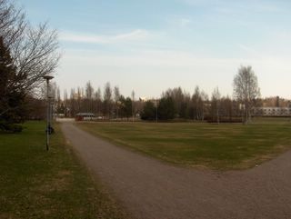
Kylmä pohjoistuuli oli tässä vaiheessa heikkenemässä ja pilvisyys vähenemässä, kun Grönlannissa olleesta korkeapaineesta ulottui nyt Suomen lounais- ja eteläpuolelle korkeapaineen selänne. Ilmamassa oli niin kylmää (päivälämpötila ko. päivänä edelleen koko eteläisessä Suomessa vain n. +10 astetta), että hallaa oli jo edellisenä yönä ja seuraava yönä oli jopa 2m korkeudella pakkasta (tällä alueella -2,4 astetta). Se aiheutti joillekin kasvuun lähteneille kasveille pakkasvaurioita; esim. tammen (Quercus robur) juuri puhjenneet lehdet tuhoutuivat monin paikoin etenkin sisämaassa. Kuvassa kasvukausi ei ollut kylmyyden vuoksi edennyt käytännössä lainkaan edelliseen kuvaan verrattuna. Niinpä kuvan rusokirsikka (Prunus sargentii) jatkoi edelleen kukintaa. Taivaalla seilasi vielä kumpukerrospilviä pohjoistuulessa ja taivas oli vahvan sininen kylmän polaarisen ilmamassan oltua kuivaa. Seuraavaan yöhön mennessä sää selkeni lähes kokonaan. Säätilanne: valitse 16.5.2006; Wetter3 A. Wetter3 B.
The cold northerly wind was weakening at this stage and the cloudyness was decreasing, as a ridge of high pressure was now reaching southwestern and southern side of Finland from the high pressure situated in Greenland. The air mass was so cold (the afternoon temperature in this day was further only about +10 C in whole southern Finland), that at the last night there was allready ground frost and during the next night there was frost (in this area -2,4 C) even in the height of 2 metres. That caused frost damage to some plants, that had been started to grow; for example just unfolded leaves of English Oak (Quercus robur) were damaged in many places especially in inland areas. In the picture due to the coldness the growing season hadn't been progressed at all in practise as compared to the previous picture. Therefore Sargent Cherry (Prunus sargentii) in the picture continued further the blooming. In the sky there were yet floating stratocumulus clouds with the northerly wind and the sky was strongly blue as the cold polaric air mass was dry. The weather turned allmost completely clear by the next night. Weather condition: choose 16.5.2006; Wetter3 A. Wetter3 B.
Helsingin Puistolan säätilasto toukokuussa 2006 - Weather chart of Puistola, Helsinki in May 2006.Flickr 1 Flickr 2
Tehoisa lämpösumma - The Effective Temperature Sum: 127,5
 Tämä kuva päättää tämän kolmen kuvan sadekuurosarjan, jossa aurinko oli taas pilven takana, mutta alemmissa kahdessa kuvassa ollut sadekuuropilvi oli etääntynyt kuvassa nähtävälle kaakkoiselle taivaanrannalle. Ko. pilven kumpumuodot olivat tässä hyvin nähtävissä. Tietyssä vaiheessa ko. pilvessä oli nähtävissä myös upeita ns. mammatusmuotoja. Vaikka ko. päivänä tuli montakin sadekuuroa ja jotkut niistä olivat melko rankkojakin, niin siitä huolimatta sademäärä jäi melko vähäiseksi; kuurojen kestot olivat lyhyitä. Joka tapauksessa huhtikuun puolelta alkanut sateeton jakso päättyi tähän ilman viilenemiseen. Paahteisimmilla paikoilla kuivuutta oli jo paikoin kehittynyt hieman ennen näitä kuuroja. Kasveille siitä ei vielä ollut mainittavaa haittaa ja ruohikkopalojen vaarakin väistyi, kun uusi kasvu korvasi kuun alun aikana vanhat kuivuneet korret. Säätilanne: valitse 15.5.2006; Wetter3 A. Wetter3 B.This picture ends this three picture shower series, where the sun was again behind a cloud, but the showercloud / cumulonimbus cloud seen in the lower two pictures had now been drawn away to the southeastern horizon seen in the picture. The cumulus shapes of this cloud were finely visible here. At a certain moment wonderfull so called mammatus shapes were also there to be seen in this cloud. Allthough there were many showers during this day and some of them were rather heavy, there wasn't much precipitation measured; durations of the showers were short. In any case a dry period, that started in April ended here in this cool down of the weather. On scorching places there were locally a little drought formed allready before these showers. It didn't cause mentionable harm to the plants yet and also the risk of grass fires withdrew as the new growth replaced the old dry straws. Weather condition: choose 15.5.2006; Wetter3 A. Wetter3 B.Helsingin Puistolan säätilasto toukokuussa 2006 - Weather chart of Puistola, Helsinki in May 2006.Flickr 1 Flickr 2
Tehoisa lämpösumma - The Effective Temperature Sum: 125,8
 Vain minuuttia myöhemmin edelliseen kuvaan verrattuna sadekuuro oli juuri lakkaamassa ja aurinko tuli pilven takaa esiin. Nyt valaistusolosuhteet olivat dramaattiset, kun ko. kuuropilvi oli taivaalla kuvaussuunnassa hyvin tummana; auringonvalon kirkkaus synnyttää kontrastin. Tässä havaitaan nyt erinomaisesti myös kasvukauden tilanne, jossa tuo vasemman laidan rusokirsikka (Prunus sargentii) oli nyt täydessä kukassa. Sen kukinta pitkittyi vielä sopivasti alkaneessa viileässä ilmassa. Muutoin ko. kukinta olisi mennyt hyvin nopeasti ohi. Lämpimämmillä paikoilla ko. puulle ehti paikoin käydä niin. Suomen yleisistä puulajeista rusokirsikan kanssa oli kukassa metsävaahtera (Acer platanoides) ja tuomi (Prunus padus) oli kukinnan alussa. Tässä vaiheessa monet nurmikotkin olivat ehtineet kasvaa sen verran, että näinä aikoina niitä leikattiin ensimmäisen kerran tänä vuonna. Säätilanne: valitse 15.5.2006; Wetter3 A. Wetter3 B.Only one minute later as compared to the previous picture the shower was just ending and the sun came out behind the cloud. Now the lighting situation was dramatic, as this cumulonimbus / showercloud was very dark in the sky in the direction of the photoshoot; the brightness of the sunlight creates a contrast. In here we can observe splendidly also the situation of the growing season, where that Sargent Cherry (Prunus sargentii) on the left was now in full bloom. The flowering of it prolonged yet suitably in the beginned cool weather. Otherwise that bloom would have been gone away very fast. On warmer places there was time to that to happen locally to this tree. Among common trees of Finland Norway Maple (Acer platanoides) was blooming at the same time as Sargent Cherry and Bird Cherry (Prunus padus) was at the beginning stage of blooming. At this time also many lawns had been growing in such a way, that at these times they were being mowed for the first time during this year. Weather condition: choose 15.5.2006; Wetter3 A. Wetter3 B.Helsingin Puistolan säätilasto toukokuussa 2006 - Weather chart of Puistola, Helsinki in May 2006.Flickr 1 Flickr 2
Tehoisa lämpösumma - The Effective Temperature Sum: 125,8
 Edellisen kuvan jälkeen aluksi pieni korkeapaineen selänne ulottui Pohjois-Venäjältä Etelä-Suomeen, jolloin vähän aikaisempaa viileämmässä ilmassa kahtena yönä oli paikoin hallaa. Kuun 13. päivä oli vielä kuitenkin lämmin (ylin lukema +17,4 astetta), mutta lännessä ja luoteessa jo edellisen kuvan ajaksi kehittynyt matalapaine voimistui 13. päivänä ja seuraavana päivänä se liikkui Suomen yli koilliseen. Matalapaineen jälkipuolella koko Suomeen pääsi vaikuttamaan voimakas luoteis - pohjoistuuli, joka toi hyvin kylmää ilmaa aina Pohjoisnavalta saakka vesi- ja raekuurojen kera; kuurot olivat runsaimmillaan ko. päivänä. Viileneminen tuntui voimakkaimmin näiden kolmen yllä olevan kuvan päivänä, jolloin päivälämpötila jäi vain +9,6 asteeseen. Muutos oli siten dramaattinen verrattuna aikaisempaan helleaaltoon. Tässä vaiheessa tuulen ja pilvien takia ei kuitenkaan ollut hallaa, vaikka yölämpötila ko. päivänä oli matala. Nämä kolme kuvaa näyttävät erilaisia valaistustilanteita erään melko rankan sadekuuron mentyä kuvauspaikan yli. Tässä alimmassa kuvassa ko. sadekuuro satoi juuri kuvan ottamisen hetkellä ja aurinko kuulsi vähän kuuropilven takareunalta. Säätilanne: valitse 15.5.2006; Wetter3 A. Wetter3 B.After the previous picture at first a small ridge of high pressure was reaching southern Finland from northern Russia. At that time in a little bit cooler air than before there was locally ground frost at two nights. However the 13th day was yet warm (the maximum reading was +17,4 C), but the low pressure formed allready for the time of the previous photo strengthened at the 13th day and during the next day it moved to the northeast over Finland. In the afterside of the low pressure whole Finland was started to affect by a strong and very cold northwesterly - northerly wind, which brought cold air all the way from the North Pole with rain and hale showers; the showers appeared the most plentyfully during this day. The cool down of the air felt the most during this day, when these three pictures above were captured as the afternoon temperature stayed only at +9,6 C. Therefore the change was dramatic as compared to the previous heatwave. However at this stage there wasn't ground frost due to the clouds and the wind, allthough the night temperature of this day was low. These three pictures show different lighting situations as one rather heavy shower crossed the scene. In this lowest picture this shower poured the rain at the moment of the photoshoot and the sun glowed a little through the backside of this cumulonimbus cloud. Weather condition: choose 15.5.2006; Wetter3 A. Wetter3 B.Helsingin Puistolan säätilasto toukokuussa 2006 - Weather chart of Puistola, Helsinki in May 2006.Flickr 1 Flickr 2
Tehoisa lämpösumma - The Effective Temperature Sum: 125,8
Edellisen kuvan tilanteen jälkeen lämpöaalto vielä voimistui uudestaan niin, että edellisenä päivänä ennen tätä kuvaa päivälämpötila kävi tällä paikalla +22,5 asteessa. Lämpöaallon aiheuttanut korkeapaine oli kuitenkin tässä vaiheessa jo heikentyneenä ja hajanaisena Pohjois-Venäjän, Skandinavian ja pohjoisen Atlantin alueella ja Pohjois-Skandinavian tienoille oli muodostunut pieni matalapaine. Itätuulet pitivät silti vielä yllä vähän tavanomaista lämpimämpää säätä ja ko. päivänä ylin lämpötila oli tällä paikalla +16,8 astetta ja alin +5,3 astetta. Lämmin sää edisti kasvien kasvua edelleen ja edelliseen kuvaan verrattuna vain kahden päivän aikana kehittyneet muutokset näkyvät selvästi; mm. kuvan rusokirsikka (Prunus sargentii) oli nyt jo melkein täydessä kukassa. Koko tämän lämpöaallon aikana pilviä oli hyvin vähän (kuten näissä kahdessa viimeisimmässä kuvassakin) ja yleinen ilmavirtaus oli heikkoa. Se tiesi edelleen vähän alle +10 asteisen Suomenlahden vaikutuksesta selviä iltapäivän merituulitilanteita etelärannikolla. Tämän vaikutuksesta etelärannikon kasvukausi oli nyt jopa muutamia päiviä jäljessä Etelä-Suomen sisämaan tilanteesta; siellä tuomi (Prunus padus) oli paikoin aloittanut kukinnan, mutta ei aivan esim. tällä kuvan alueella. Kasvukausi oli nyt suunnilleen 1 - 2 viikkoa edellä normaalista. Säätilanne: valitse 10.5.2006; Wetter3 A. Wetter3 B.
After the situation of the previous picture the wave of warm weather got stronger again in such a way, that in the previous day before this picture the afternoon temperature was in this area +22,5 C. However the high pressure responsible for this warm weather was now weakened and dispersed over northern Russia, Skandinavia and northern Atlantic and around northern Skandinavia a small low pressure had been formed. Easterly winds maintained further a bit warmer than the average weather though and in this day the maximum temperature was +16,8 C and the minimum +5,3 C. The warm weather helped the growing of the plants further and when compared to the previous picture the changes formed during only two days are showing clearly; for example in this picture Sargent Cherry (Prunus sargentii) was now allmost in full bloom. During this whole wave of warm weather there were very little amount of clouds (as in these latest two pictures as well) and the overall wind condition was calm. That meant clear sea breeze situations during afternoons by the southern coast due to The Gulf Of Finland, which was yet a bit under +10 C. Because of this the growing season was now even a few days late by the southern coast as compared to the situation in the inland areas of southern Finland; there Bird Cherry (Prunus padus) had been started flowering locally but not quite in the area of this photo for example. Approximately the growing season was now ahead about 1 - 2 weeks of the normal stage. Weather condition: choose 10.5.2006; Wetter3 A. Wetter3 B.
Helsingin Puistolan säätilasto toukokuussa 2006 - Weather chart of Puistola, Helsinki in May 2006.Flickr 1 Flickr 2
Tehoisa lämpösumma - The Effective Temperature Sum: 105,7

Edellisten kuvien tilanteesta sää oli lämmennyt tätä kuvaa edeltävään päivään asti koko ajan ja tuolloin lämpöaalto oli huipentunut niin, että tällä alueella ylin lämpötila oli jopa +24,8 astetta ja sisämaa-alueilla +25 astetta (helleraja) oli ylitetty ja kahtena edellisenäkin päivänä. Öisin lämpötila oli +5 asteen vaiheilla eikä hallaa ollut. Lämpimän ja aurinkoisen sään aiheutti Suomen ja Skandinavian yllä ollut keskileveysasteiden ilmamassan korkeapaine, jonka painopiste oli kuitenkin siirtynyt tässä vaiheessa länteen ja vähän viileämmät itätuulet olivat alkaneet vaikuttamaan; päivälämpötila jäi nyt vähän alle +20 asteen. Tällä kuvauspaikalla kasvukausi on normaalistikin tähän aikaan hyvällä alulla, mutta nyt se oli kirinyt lämpöaallossa edelle tavanomaisesta; suurimpaan osaan puista niin luonnossa kuin puutarhoissa ja puistoissa oli puhjenneet lehdet ja esim. koivut (Betula sp.) kukkivat nyt runsaasti aiheuttaen paljon siitepölyä ilmaan. Kuvassa ovat seuraavat puulajit: vasemmalla punertavana rusokirsikka (Prunus sargentii), sen takana kontortamänty (Pinus contorta), käytävän päässä pylväshaapaa (Populus tremula "Erecta"), valkorunkoiset puut ovat rauduskoivuja (Betula pendula) ja niiden mukana keskellä kuvaa on metsämäntyjä (Pinus sylvestris). Maiseman vihreyden lisääntyminen oli näinä lämpiminä päivinä päivittäin havaittavaa. Säätilanne: valitse 8.5.2006; Wetter3 A. Wetter3 B.
From the situation of the previous picture onwards the weather had been warming all the time up to the day before of this picture and then this wave of warm air had been culminated in such a way, that in this region the maximum temperature was even +24,8 C and in inland areas +25 C (this is classified in Finland as the limit of heatwave) was topped allready two days earlier as well. At nights the temperature was around +5 C and there wasn't ground frost. The warm and sunny weather was resulted by the high pressure of the middle latitude air mass situated over Finland and Skandinavia. However the center of that high pressure had been moved to the west at this stage and a little cooler easterly winds had been started to affect; the afternoon temperature stayed now a bit under +20 C. In this photoshooting scene the growing season is also normally in a fine start at this time of the year, but now it had been pushed ahead of the average in the warm weather; leaves had been unfolded in most of the trees both in nature and in gardens and parks and for example birches (Betula sp.) were now in bloom shedding very much pollen into the air. In the picture there are the following tree species: on the left in reddish colour Sargent Cherry (Prunus sargentii), behind it Lodgepole Pine (Pinus contorta), at the end of the path Columnar European Aspens (Populus tremula "Erecta"), the white truncked trees are Silver Birches (Betula pendula) and among them in the middle of the picture are Scots Pines (Pinus sylvestris). The increasing of the landscape's green colour was noticeable daily during these warm days. Weather condition: choose 8.5.2006; Wetter3 A. Wetter3 B.
Helsingin Puistolan säätilasto toukokuussa 2006 - Weather chart of Puistola, Helsinki in May 2006.Flickr 1 Flickr 2
Tehoisa lämpösumma - The Effective Temperature Sum: 86,6
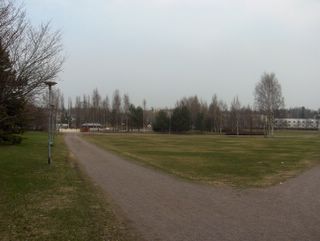
Tässä kuvassa aurinko tuli hetkeä myöhemmin kumpupilven takaa pois verrattuna alempaan kuvaan, joka oli kuvattu melkein samaan aikaan ko. päivänä. Sää oli siis nyt lämmin ja sen myötä ihmiset alkoivat nauttimaan ulkonaolosta huomattavasti enemmän; kuvassakin puiston penkillä (vasemmalla) auringosta nautti kaksi vanhempaa ihmistä. Aurinkoa todella riittikin tässä vaiheessa vuotta, sillä aurinko laski vasta puoli yhdeksän maissa ja se nousi heti aamu neljän jälkeen. Laajat nurmikot kuvauspaikalla Espoon Tapiolassa houkuttelivat tyypillisesti tällaisella säällä mm. pallopeleihin, kuten jalkapallon peluuseen. Lämmin ja aurinkoinen sää vaikutti nyt paljon myös vesistöjen lämpenemiseen; mitä pienempi vesistö on kyseessä, niin sitä nopeammin se lämpenee. Pienet lammet olivat lämmenneet tässä vaiheessa jo yli +10 asteisiksi. Säätilanne: valitse 4.5.2006. Wetter3 A. Wetter3 B.
In this picture the sun came out a moment later from behind a cumulus cloud as compared to the previous picture, which was photographed allmost at the same time in this day. So, the weather was warm now and due to that people started to enjoy signifigantly more of the outdoor activities; in the picture as well two elderly people enjoyed the sun on the park bench (on the left). There was plenty of sun indeed at this time of the year, because the sun was setting as late as about half past eight and it rose just after four o'clock in the morning. The large areas of lawns in the photoshooting scene in the district of Tapiola in Espoo invited people during this kind of weather typically to play ball games, like football / soccer. The warm and sunny weather affected now greatly also to the warming of the water areas; the smaller the water area is, the faster it becomes warmer. Small ponds had been warming up at this stage allready over +10 C. Weather condition: choose 4.5.2006; Wetter3 A. Wetter3 B.
Helsingin Puistolan säätilasto toukokuussa 2006 - Weather chart of Puistola, Helsinki in May 2006.Flickr 1 Flickr 2
Tehoisa lämpösumma - The Effective Temperature Sum: 47,9
Kasvukausi ei ehtinyt edetä niin paljon edelliseen kuvaan verrattuna yhdessä päivässä, että se olisi tässä selvästi havaittavissa. Päivälämpötila oli kuitenkin ko. päivänä jo +19,1 astetta ja Etelä-Suomen sisämaassa vain n. 10 - 20km pohjoisempana +20 astetta ylitettiin reilusti. Sää oli siis äitymässä jopa poikkeuksellisen kesäiseksi ajankohtaan nähden. Edellisenä yönä tämän paikan lämpötila laski +2,3 asteeseen vähäisten pilvien takia, joten etenkin sisämaa-alueilla oli vielä hallaa. Seuraava yö oli kuitenkin jo selvästi lämpimäpi. Yhä enemmän lämpenevän sään aiheutti aikaisemminkin mainittu korkeapaine, joka laajeni nyt Suomen ja Pohjois-Venäjän ylle aiheuttaen laajalla alueella Venäjällä ja Euroopassa lämpöaallon ison matalapaineen auttaessa tilannetta pohjoisella Atlantilla; lämpimiä etelä- ja kaakkoistuulia Euroopan alueella. Yllä on kaksi samana ko. päivänä kuvattua tilannetta. Tässä alemmassa kuvassa aurinko oli iltapäivän kumpupilven takana. Ko. pilviä esiintyi vähän mantereen päällä, mutta kuvassa näkyvä taivas meren yllä oli selkeä untuvapilviä lukuun ottamatta; merituuli. Säätilanne: valitse 4.5.2006; Wetter3 A. Wetter3 B.
The growing season hadn't had time to progress so much in one day as compared to the previous photo, that it would have been clearly noticeable here. However the afternoon temperature of this day was allready +19,1 C and in the inland areas of southern Finland only about 10 to 20 kilometres north from here +20 C was topped clearly. So the weather was starting to be unusually summery for the time of the year. At last night the temperature in this place dropped to +2,3 C due to a small amount of clouds and therefore especially in inland areas there was ground frost. The next night however was allready clearly warmer. The further more warming weather trend was resulted by the high pressure mentioned also earlier, which was now widening over Finland and northern Russia causing a wave of warm air in large areas in Russia and Europe as a big low pressure in northern Atlantic was helping the situation; warm south and southeasterly winds around Europe. Above there are two situations in the pictures photographed during this same day. In this lower picture the sun was behind a afternoon cumulus cloud. These clouds were appearing a little over the continent, but the sky in the picture over the sea was clear not counted for the cirrus clouds; the sea breeze. Weather condition: choose 4.5.2006; Wetter3 A. Wetter3 B.
Helsingin Puistolan säätilasto toukokuussa 2006 - Weather chart of Puistola, Helsinki in May 2006.Flickr 1 Flickr 2
Tehoisa lämpösumma - The Effective Temperature Sum: 47,9
Edellisen kuvan jälkeen Suomen itäpuolella edelleen vahvana vaikuttanut korkeapaine lähestyi Suomea 29. ja 30. huhtikuuta siten, että se kierrätti ko. päiviksi idästä vähän viileämpää ilmaa ja päivälämpötilat jäivät vähän alle +15 asteen etenkin rannikolla (merituuli). Ajoittaisten pilvien ja tuulen ansiosta öisin ei ollut pakkasta, mutta hallaa kuitenkin monin paikoin. Toukokuun 1. päivästä lähtien ko. korkeapaine muotoutui Suomen yllä ja heti sen itäpuolella siten, että kuvauspäivänä ilma virtasi aikaisempaa pidemmältä etelästä, mikä tiesi sään lämpenemistä uudelleen. Kuvauspäivän ylin lämpötila oli +17,0 astetta, vaikka samalla Suomen ylle oli tullut lounaasta vanha katoava okluusiorintama kuvassa nähtävine lähes kokonaan auringon peittäneine harso- ja verhopilvineen. Pilvien myötä ko. yön lämpötila jäi alueella ensimmäistä kertaa +5 asteen yläpuolelle tänä keväänä. Tässä vaiheessa myös utu oli jälleen lisääntynyt kuun vaihteen kirkkaammasta ilman tilanteesta. Sadetta ei kuitenkaan tullut ollenkaan. Kuvassa nähdään, kuinka nämä lämpimähköt päivät olivat edistäneet kasvukautta hyvään alkuun; numikko oli jo vihertynyt selvästi. Samaan aikaan mm. tuomi (Prunus padus) oli hiirenkorvalla (ensimmäinen luontainen puu Suomessa hiirenkorvalla keväisin) ja sinivuokot (Hepatica nobilis) kukkivat. Kaikki routa ja kaikkien vesistöjen jäät olivat nyt käytännössä sulaneet, mutta veden lämpötila esim. Suomenlahdessa oli vain muutamia plusasteita. Säätilanne: valitse 3.5.2006; Wetter3 A. Wetter3 B.
After the previous picture the high pressure, that affected further in the eastern side of Finland moved towards Finland at the 29th and 30th days in a way, that it circulated a bit cooler air from the east for those days and the maximum temperatures stayed a little under +15 C especially by the coast (the sea breeze). Due to occasional clouds and winds there wasn't nightfrosts, but ground frost in many places though. From the 1st of may onwards this high pressure was forming over Finland and right next in the eastern side of it in such way, that during the photoshooting day winds were coming further away from the south than before, which meant the weather getting warmer again. The maximum temperature of the day was +17,0 C, allthough a vanishing occluded front had been arrived over Finland with allmost the sun obscuring cirrostratus and altostratus clouds seen in the picture. Due to the clouds the temperature of this night stayed for the first time in this spring over +5 C. At this stage also haze had been increased after more clearer condition of the air at the turn of the month. However there wasn't rain at all. In the photo we see, how these rather warm days had been helped the growing season to a fine start; the lawn had been getting clearly green allready. At the same time for example leaves of Bird Cherry (Prunus padus) had just been unfolded (the first native tree in Finland to unfold leaves during spring) and Common Hepaticas (Hepatica nobilis) were in bloom. All ice in all kinds of water areas had been melted now, but the temperature of the water for example in The Gulf Of Finland was only couple of degrees above the freezing mark (0 C). Weather condition: choose 3.5.2006; Wetter3 A. Wetter3 B.
Helsingin Puistolan säätilasto toukokuussa 2006 - Weather chart of Puistola, Helsinki in May 2006.Flickr 1 Flickr 2
Tehoisa lämpösumma - The Effective Temperature Sum: 40,7