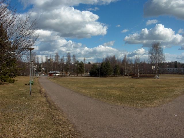
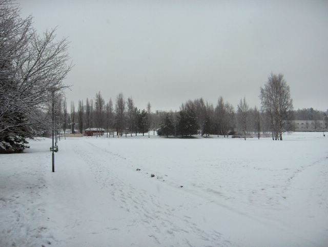
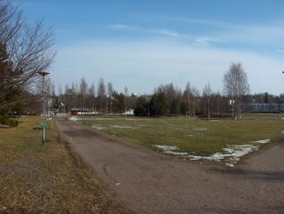
Tänä päivänä jatkui samanlainen sää kuin edellisenä päivänä ja lämpötilatkin olivat lähes samat sekä yöllä että päivällä. Sisämaa-alueilla Etelä-Suomessa päivän ylimmät lämpötilat hipoivat kuitenkin jo +20 astetta. Kuvassa nähdään erona edelliseen kuvaan verrattuna lähinnä vain hyvin vähäiset untuvapilvet. Parin päivän aikana hieman lisääntynyt utu oli tyypillistä kehittyneelle lämpimälle keskileveysasteiden ilmamassalle. Kasvukauden alkaminen tässä vaiheessa sisälsi krookusten (Crocus sp.) kukinnan lisäksi myös harmaa- (Alnus incana) ja tervalepän (Alnus glutinosa) sekä euroopanpähkinäpensaan (Corylus avellana) kukinnat. Tämän vuoksi ilman siitepölymäärä oli kohonnut nyt ensimmäisen kerran korkeaksi tänä keväänä. Erittäin kylmän maaliskuun ja hyvin pilvisen huhtikuun alun takia näiden lajien kukinta viivästyi, mutta nyt se kiri viivettä kiinni ja kasvukausi alkoi muutenkin tavanomaiseen aikaan Etelä-Suomessa. Säätilanne: valitse 27.4.2006; Wetter3 A. Wetter3 B.During this day the same kind of weather continued like in the previous day and the temperatures were also allmost the same both at night and in the afternoon. However in inland areas in southern Finland the maximum temperatures of the day were reaching allmost +20 C. In the picture as compared to the previous photo we see the only difference being mainly very little amount of cirrus clouds. A slightly increased haze during couple of previous days was typical of the formed middle latitude air mass. The start of the growing season included at this phase among the blooming of the crocuses (Crocus sp.) bloomings of Grey Alder (Alnus incana), Black Alder (Alnus glutinosa) and European Hazel (Corylus avellana). Due to this the pollen count of the air had been increased now to high levels for the first time during this spring. Due to very cold March and very cloudy early April the blooming of these species were delayed, but now the delay was pushed narrower and the growing season started also otherwise in an average time in southern Finland. Weather condition: choose 27.4.2006; Wetter3 A. Wetter3 B.Helsingin Puistolan säätilasto huhtikuussa 2006 - Weather chart of Puistola, Helsinki in April 2006.
Flickr 1 Flickr 2
Tehoisa lämpösumma - The Effective Temperature Sum: 11,7 
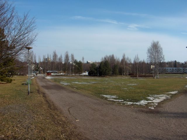
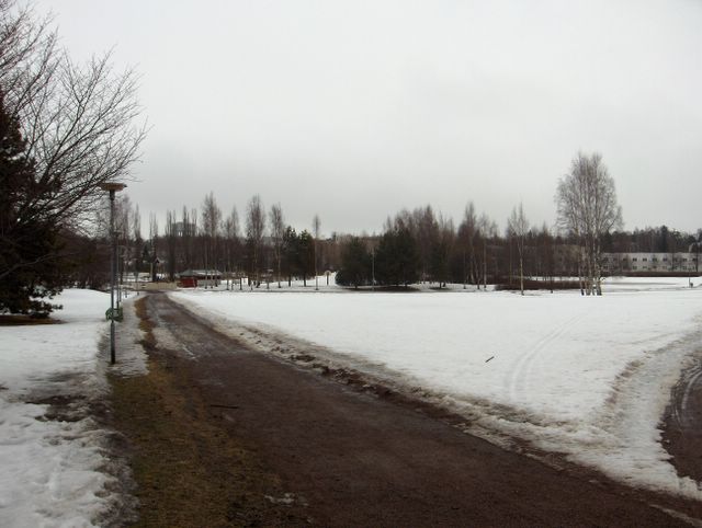
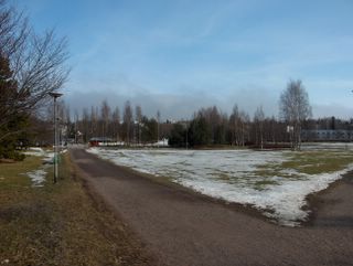
 Edellisen kuvan tilanteen jälkeen pohjoistuulen tilalle vahvistui korkeapaine, jonka painopiste siirtyi koilliseen Pohjois-Venäjälle. Tämän myötä ilmaa virtasi heikosti koko ajan kaakosta ja etelästä Suomeen. Korkeapaineen keskustan alueella kaukana koillisessa vallitsi vielä Siperian pakkaskorkeapaineen kaltainen talvitilanne, mutta Suomessa tämä tiesi päivä päivältä yhä enemmän lämpenevää säätä tässä vaiheessa vuotta. Kuvan tilanteessa päivälämpötila nousi ensimmäistä kertaa yli +15 asteen (ylin lukema oli +15,1 astetta) ko. keväänä. Merituuli kuitenkin vaikutti sen verran tällä rannikkoalueella, että sisämaassa n. 20 - 30 km pohjoisempana +15 astetta ylitettiin selvästi jo kahta päivää aikaisemminkin. Pilvisyys oli edellisestä kuvasta lähtien koko ajan hyvin vähäistä (vain untuvapilviä ja sisämaassa joinakin iltapäivinä myös kumpupilviä), joten yöpakkasta oli vielä muutamana yönä -4,5 asteeseen saakka. Ko. päivän yönä yöpakkasta ei enää ollut ilmamassan lämmettyä jo sen verran. Kasvukausi oli nyt alkamassa, joten termi halla otettiin käyttöön. Ko. yönä oli tyypillinen hallatilanne, jossa muutoin oli plusasteita sään oltua tyyntä ja selkeää. Kasvukauden alku näkyi nyt silmujen pullistumisena, aikaisten sipulikasvien kukkimisena (kuten sahramit eli krookukset) ja paikoin vihertyneinä nurmikkoina (kuten kuvassa hennosti vasemmalla). Jäät olivat sulaneet melkein kokonaan järvistä ja Suomenlahdesta. Säätilanne: valitse 26.4.2006; Wetter3 A. Wetter3 B.After the situation of the previous picture the northerly wind had been replaced by a strengthened high pressure, where the emphasis of it moved to the northeast in northern Russia. Due to that the air flowed weakly all the time from the south and southeast to Finland. Around the center of the high pressure far in the northeast a wintry frosty high pressure of Siberia -like situation was yet prevailing, but in Finland this meant warming up of the weather day by day further more at this time of the year. In the situation of the photo the afternoon temperature topped for the first time +15 C (the maximum reading was +15,1 C) during this spring. However the sea breeze affected in this coastal area in such a way, that +15 C was topped clearly in inland areas about 20 to 30 kilometres to the north two days earlier as well. There were very little clouds all the time since the previous picture (only cirrus clouds and in inland areas also cumulus clouds during some afternoons), so therefore there were nightfrosts in few nights down to -4,5 C. In the night of this day there wasn't nightfrost anymore, because the air mass had been warmed up in such a way allready. The growing season was starting now, so the term ground frost (halla in finnish) was brought in use. At this night there was a typical ground frost situation, where the temperature was otherwise above the freezing point as the winds were calm and the sky was clear. The start of the growing season appeared now as a swelling of puds, a blooming of early bulbous plants (like crocuses) and a local greenish tone of lawns (as seen slightly in the picture on the left). The ice had been melted allmost completely from lakes and The Gulf Of Finland. Weather condition: choose 26.4.2006; Wetter3 A. Wetter3 B.Helsingin Puistolan säätilasto huhtikuussa 2006 - Weather chart of Puistola, Helsinki in April 2006.
Flickr 1 Flickr 2
Tehoisa lämpösumma - The Effective Temperature Sum: 7,5
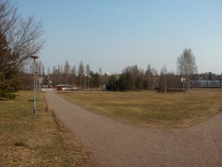
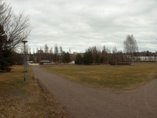
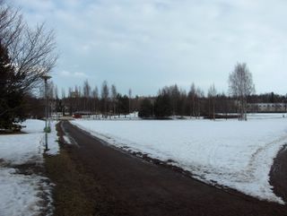
 Nyt pohjoistuuli oli voimistunut melko voimakkaaksi edellisen päivän matalapaineen siirryttyä täksi päiväksi Suomen itäpuolelle. Ilmamassa ei kuitenkaan viilentynyt aikaisemmasta, vaan nyt päivälämpötila ylitti ensimmäisen kerran tällä seudulla +10 asteen (ylin lukema oli +10,1 astetta), kun aurinko pääsi jälleen paremmin esille iltapäivällä. Yöllä ei ollut pakkasta tuulen ja pilvien takia. Kuvassa nähdään runsaasti tuulen mukana nopeasti seilanneita kumpupilviä, jotka olivat tyypillisiä tässä viileässä polaarisessa ilmamassassa. Ne paljastivat kevään edistyneen jo pitkälle termiikin kertomana. Pohjoistuulen takia merituuli kumoutui, joten pilvet seilasivat myös meren ylle. Nurmikot näyttivät tässä vaiheessa kaikkein ruskeimmilta juuri ennen uuden kasvun alkua, kun korret olivat kuivuneet. Sen takia ruohikkopalojen vaara kasvoi. Tässä vaiheessa lunta ei enää ollut joitakin hyvin yksittäisiä varjopaikkoja lukuun ottamatta, mutta Etelä-Suomen järvissä ja Suomenlahdessa oli edelleen haurasta jäätä monin paikoin. Jäät olivat muuttuneet nyt tyypillisesti sohjoisiksi kerroksiksi; ne näkyvät tumman vihertävän harmaina sinisen veden päällä, kun taivas on selkeä - osittain selkeä. Jokien kevättulvat olivat kääntyneet laskuun. Säätilanne: valitse 21.4.2006; Wetter3 A. Wetter3 B.Now a northerly wind had been picked up as the low pressure of the previous day moved to the eastern side of Finland for this day. However the air mass didn't turn cooler than before, but the afternoon temperature was topped +10 C for the first time in this area, because the sun was exposed again better in the afternoon. At night there wasn't frost due to clouds and the wind. In the picture we see plenty of cumulus clouds floated in a fast pace with the wind. They were typical in this cool and polaric airmass, which revealed that the spring had advanced allready far as told by the thermal. The sea breeze was subverted by the northerly wind and therefore the clouds were floating also over the sea. The lawns looked at this stege the most brown as the straws had been dried. Due to that a risk of grassfires increased. At this time there weren't snow anymore not counted for very single spots in shadows, but there were brittle ice left in many places in lakes of southern Finland and in The Gulf Of Finland. The ice had been turned now typically into slushy layers; they appear as dark and greenish grey on the surface of the blue water, when the sky is clear - partly clear. The spring floods of rivers had been started to dissipate. Weather condition: choose 21.4.2006; Wetter3 A. Wetter3 B.Helsingin Puistolan säätilasto huhtikuussa 2006 - Weather chart of Puistola, Helsinki in April 2006.
Flickr 1 Flickr 2
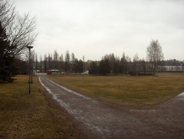
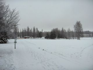
 Edellisenä päivänä Etelä-Skandinaviassa oli kehittynyt pieni matalapaine, joka tämän kuvan tilanteessa oli Etelä-Suomen päällä. Sen okluusiorintamaan liittynyt sadealue toi vesisadetta kohtalaisesti ja kuvan ottamisen hetkelläkin satoi melko reippaasti, kuten kuvan hyvin märästä puistokäytävästä voidaan nähdä. Pilvinä taivaalla olivat siis sadepilvet sumupilvien kanssa. Tuuli oli kuitenkin sen verran heikkoa (enintään kohtalaista etelätuulta ennen sadetta ko. päivänä), että kuvaaminen onnistui sateessa sadevarjon kanssa. Ko. yönä sää oli seljennyt sen verran, että yöpakkasta oli -2,6 astetta. Ilmamassa pysyi edelleen viileänä sateen tullessa, joten päivälämpötila jäi vielä vain +7,6 asteeseen. Niinpä kasvukauden alku ei aivan vielä ollut käsillä, mutta vesisade sulatti tehokkaasti jäljellä olleita paikallisia lumilaikkuja ja routaa. Säätilanne: valitse 20.4.2006; Wetter3 A. Wetter3 B.During the previous day in the southern Skandinavia a small low pressure had been formed, which was in the situation of this photo over southern Finland. A precipitation area associated with a occluded front of the low pressure brought rain moderately and also at the time of the photoshoot it rained rather profusely, as we can see from the very wet path of the park in the picture. So the clouds in the sky were nimbostratus clouds with stratus clouds. However the wind was weak in such a way (moderate southerly winds at the most before the rain), that the photographing succeeded finely in the rain with an umbrella. During this night the weather had been cleared so much, that there was frost at night for -2,6 C. The air mass stayed further cool as the rain came, so the afternoon temperature stayed yet at only +7,6 C. Therefore the start of the growing season wasn't at hand just yet, but the rain was melting effectively the remains of local snow patches and soil frost. Weather condition: choose 20.4.2006; Wetter3 A. Wetter3 B.Helsingin Puistolan säätilasto huhtikuussa 2006 - Weather chart of Puistola, Helsinki in April 2006.
Flickr 1 Flickr 2
 Suomen luoteispuolella ollut matalapaine kierrätti tässä vaiheessa edelleen viileää ilmaa lännestä ja sadekuuroja (paikoin tuli myös räntää, mutta maahan siitä ei jäänyt mitään) tuli etenkin sisämaassa. Pilvisyys oli yhä runsasta, mutta aurinkokin paistoi ajoittain. Kuvassa nähdään kumpukerrospilviä ja sumupilviä toisiinsa sekoittuneina. Sumupilviä esiintyi yhä etenkin rannikolla myös päiväsaikaan kylmän meren vaikutuksesta. Pilvisyyden ja tuulen ansiosta tässä tavanomaista viileämmässä ilmamassassa yöpakkanen oli hyvin heikkoa lämpötilan oltua nollan tienoilla, mutta päivälämpötila oli matala; vain +7,3 astetta. Vielä ei voitu puhua hallasta, koska kasvukausi ei ollut vielä alkanut. Halla kuvaa maan pinnan öistä pakkasta kasvukauden aikana, jossa lämpötila 2m korkeudella voi olla pari astetta nollan yläpuolella samaan aikaan. Tämä on tärkeää, kun viljellään kasveja; halla esiintyy paikallisesti hyvin erilailla, kun lämpötila on nollan vaiheilla yöllä heikon tuulen ja selkeän taivaan aikana (lämmön ulossäteily). Säätilanne: valitse 19.4.2006; Wetter3 A. Wetter3 B.A low pressure situated in the northwestern side of Finland circulated at this stage further cool air from the west and showers (locally came also sleet, but nothing was left on the ground) came especially in inland areas. The cloudyness was further dense, but the sun shined also occasionally. In the picture we see stratocumulus clouds and stratus clouds mixed up with each other. The stratus clouds appeared further especially by the coast also in the afternoon due to the cold sea. Thanks to the wind and cloudyness in this cooler than the average air mass the nightfrost was very weak as the temperature was around zero C, but the afternoon temperature was low; only +7,3 C. There couldn't yet be talked about a so called "ground frost" (halla; a special finnish word for the phenomenon explained here), because the growing season hadn't been started yet. The ground frost (halla) describes a nightly frost during ongoing growing season on the surface of the ground, where the temperature at the altitude of 2 metres can be couple of degrees above the freezing point at the same time. This is cruisial, when cultivating plants; the ground frost (halla) is appearing locally very differently as the temperature is around zero C at night during a calm wind and the clear sky (an exit radiation of warmth). Weather condition: choose 19.4.2006; Wetter3 A. Wetter3 B.Helsingin Puistolan säätilasto huhtikuussa 2006 - Weather chart of Puistola, Helsinki in April 2006.
Flickr 1 Flickr 2
 Edellisen kuvan jälkeen Suomen länsi- ja eteläreunoilla liikkui pieniä matalapaineita ja 15. - 16. päivinä myös itäpuolella. Etelä-Suomi kuului silti lähes koko ajan näiden matalapaineiden väliseen heikkoon korkeapaineen selänteeseen vaihtelevalla tavalla. Niinpä lähinnä vain sisämaassa saatiin heikkoja iltapäiväkuuroja (vettä); rannikolla merituuli ehkäisi jo varsin hyvin sadepilvien kehittymistä. Kevään lämpimin päivä tähän mennessä oli 15. päivänä; ylin lukema +9,4 astetta. Yöpakkasia oli pilvisyyden mukaan lähes joka yö -2,5 asteeseen saakka. Lumet kuitenkin sulivat kuvauspäivään mennessä kokonaan varjoisimpia paikkoja ja isoja aurattuja lumikasoja lukuun ottamatta. Samoin kävi roudan kanssa. Edellisenä päivänä pohjoisella Atlantilla kehittynyt matalapaine toi lännestä sadealueen (vettä) okluusiorintaman myötä. Sen jälkeen heikkoina pitkään pysyneet tuulet voimistuivat ko. kuvan tilanteeseen mennessä navakaksi lounaistuuleksi. Tuuli toi viileää ilmaa ja päivän ylin lämpötila oli vain +6,6 astetta. Runsaan pilvisyyden takia ko. yönä ei silti ollut juurikaan pakkasta. Mereltä (Suomenlahti oli nyt jo yli puoliksi sula) ajautui tuulen mukana kuvan kumpukerrospilvien suuntaan kehittynyttä sumupilvikerrosta. Sisämaassa pilvityypit olivat tässä vaiheessa enemmän kumpu-, kuuro- ja kumpukerrospilviä. Heikkotuulisen jakson aikana sumua oli ollut ajoittain rannikolla kylmän meren takia. Kuvan nurmikko ei ollut vielä aloittanut kasvuaan, mutta aurinkoisimmilla paikoilla niin oli jo paikoin käynyt. Kasvukausi alkaa määritelmän mukaan vuorokauden keskilämpötilan ylitettyä +5 asteen n. viitenä peräkkäisenä päivänä, mutta näin ei ollut vielä käynyt. Säätilanne: valitse 18.4.2006; Wetter3 A. Wetter3 B.After the previous picture small low pressures were moving around western and southern edges of Finland and at the 15th to th 16th days also in the eastern side. Southern Finland beloged allmost all the time in the area of a weak ridge of high pressure though in variable ways. Therefore mainly only in inland areas weak showers (rain) came during afternoons; by the coast the sea breeze prevented allready rather effectively the formation of precipitation clouds. The warmest day of the spring so far was at 15th day; the maximum reading was +9,4 C. Nightfrosts appeared allmost every night according to cloudyness down to -2,5 C. However the snow melted away completely not counted for most shadowy places and big piles of plowed snow. The same happened with the soil frost. During the previous day a precipitation area came from the west with a occluded front brought by a low pressure formed at northern Atlantic. After the front the winds previously calm for a long period turned into a fresh / sharp southwesterly wind until the situation of this picture. The wind brought cool air and the maximum temperature of the day was only +6,6 C. Due to the plentyfull cloudyness there wasn't allmost at all frost at this night though. In the picture a layer of stratus clouds progressed towards stratocumulus clouds floated from the sea (The Gulf Of Finland was now more than half unfrozen) with the wind. In inland areas the cloud types were at this stage more like cumulus, cumulonimbus and stratocumulus clouds. During the calm wind period there had been occasionally fog by the coast due to the cold sea. The lawn in the photo hadn't been started the new growth yet, but on sunniest spots that had been happened allready locally. The growing season will start according to a definition, when the daily mean temperature have been topped +5 C in about 5 days in a row, but that hadn't been happened yet. Weather condition: choose 18.4.2006; Wetter3 A. Wetter3 B.Helsingin Puistolan säätilasto huhtikuussa 2006 - Weather chart of Puistola, Helsinki in April 2006.
Flickr 1 Flickr 2
Tässä vaiheessa lännestä oli lähestynyt matalapaine ja korkeapaine oli vetäytynyt itään. Kuvassa vallitsi kohtalainen etelätuuli, joka voimisti viileän merituulen vaikutusta (nyt merellä ei ollut sumulauttoja). Päivälämpötila oli tällä paikalla +6,8 astetta, mutta Etelä-Suomen sisämaassa oli paikoin pari astetta lämpimämpää, kun lumipeite oli jo melkein kokonaan sulanut sielläkin. Seljenneen sään vuoksi yöllä oli pakkasta -3,0 astetta. Lännen matalapaineen vaikutuksesta taivaalla oli edellistä päivää enemmän untuva- ja harsopilviä, mutta sateita ei alueelle ulottunut myöhään illallakaan. Vähäisten pilvien vuoksi aurinko sulatti lunta ja routaa tehokkaasti, jolloin erot varjoisten ja aurinkoisten paikkojen välillä kasvoivat paljon selvemmiksi. Paikoin myös routa oli sulanut kokonaan tähän mennessä. Järvien ja Suomenlahden jäät sulivat kuitenkin hitaasti (vesi lämpenee paljon hitaammin kuin maa-aines), mutta jokien jäät lähtivät virtaavan veden ja lumen sulamisesta johtuneiden tulvien ansiosta nopeasti näihin aikoihin. Säätilanne: valitse 13.4.2006; Wetter3 A. Wetter3 B.
In this situation a low pressure had been approached from the west and the high pressure had been withdrawn to the east. In the picture a moderate southerly wind prevailed, which strengthened the effect of the sea breeze (now there wasn't fog patches over the sea). The afternoon temperature was at this place +6,8 C, but in the inland areas of southern Finland it was locally couple of degrees warmer, when allmost all snowcover had allready been melted also there. Due to the cleared skies the night temperature was -3,0 C. As affected by the westerly low pressure there were more cirrus and cirrostratus clouds in the sky than the day before, but no precipitation wasn't reaching the scene even late in the evening. Due to the minor clouds the sun melted the snow and soil frost effectively and therefore differences between sunny and shadowy spots progressed much clearer. However the ice of the lakes and The Gulf Of Finland melted slowly (water warms up much slower than the soil matter), but the ice on the rivers moved away fast during these times due to the flowing water and floods caused by the melting snow. Weather condition: choose 13.4.2006; Wetter3 A. Wetter3 B.
Helsingin Puistolan säätilasto huhtikuussa 2006 - Weather chart of Puistola, Helsinki in April 2006.
Flickr 1 Flickr 2
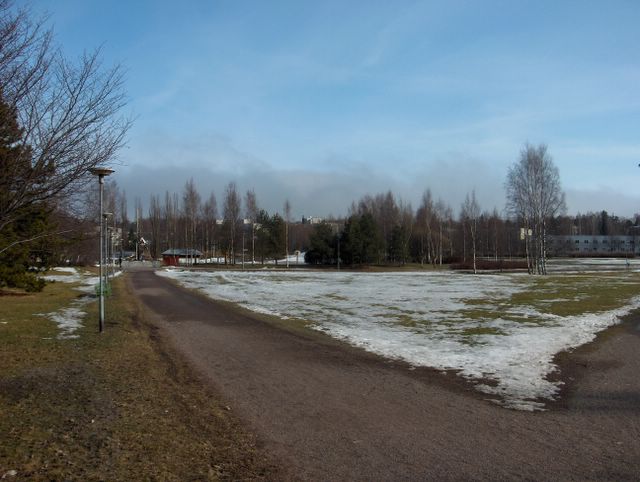
Alkaneen kevään lämpimin päivä tähän mennessä oli ollut 9. huhtikuuta, jolloin päivälämpötila ennen lännestä saapunutta sadealuetta oli +7,1 astetta. Edellisestä kuvasta lukien Suomen länsipuolella oli matalapaine, joka kierrätti sadealueita (sekä vettä että rantää) Etelä-Suomen yli koilliseen. Samalla sää lämpeni vähän. Pari päivää ennen tämän kuvan tilannetta ko. matalapaine heikentyi Suomen ylle uuden matalan asettuessa itään. Eteläpuolelle oli nyt vahvistunut pieni korkeapaine. Sää oli kuvassa siten untuvapilviä lukuun ottamatta selkeä, mutta kylmän ja vielä suureksi osaksi jäisen Suomenlahden takia vallinneessa merituulessa (lounaistuuli) merellä syntyneet sumulautat (kylmän alustan päällä ollut leudompi ilmamassa) ajautuivat ajoittain rannikolle, joita nähdään kuvan taivaanrannassa. Niiden etäisyys kuvaajaan oli vain n. 1 km. Lumipeite oli sulanut nyt nopeammin, koska vettäkin oli satanut ja aurinko lämmitti n. +5 asteen lämmössä tehokkaasti eri pintoja. Routa oli alkanut sulaa myös maan päältä käsin lumettomilla kohdilla. Puistokäytävä alkoi kuivua paikoin paremmin, koska sen alla oleva routa oli sulanut niiltä kohdilta kokonaan. Säätilanne: valitse 12.4.2006; Wetter3 A. Wetter3 B.
The warmest day of the beginned spring so far had been at the 7th of april, when the temperature at noon before the precipitation area arriving from the west was +7,1 C. From the previous picture onwards there was a low pressure in the western side of Finland, which circulated precipitation areas (both rain and sleet) over southern Finland to the northeast. At the same time the weather got warmer a bit. A couple of days before the situation of this picture that low pressure weakened over Finland as a new low pressure settled in the east. In the south there was now strengthened a small high pressure. The weather was therefore clear in the picture not counted for the cirrus clouds, but in the prevailed sea breeze (a southwesterly wind) due to cold and for the most part yet frozen The Gulf Of Finland fog patches formed at sea (the milder air over the cold surface) were floating to the coast, which can be seen in the photo in the horizon. The distance between them and the photographer was only about 1 kilometer. The snowcover had been melted faster now, because it had also been rained and the sun warmed up different surfaces effectively when the temperature was about +5 C. The soil frost had been started to melt also from over the ground. The path in the park started to dry up locally better, because the soil frost underneath of it had been melted completely from those spots. Weather condition: choose 12.4.2006; Wetter3 A. Wetter3 B.
Helsingin Puistolan säätilasto huhtikuussa 2006 - Weather chart of Puistola, Helsinki in April 2006.
Flickr 1 Flickr 2
Tässä iltapäivän tilanteessa edellisen päivän pieni matalapaine oli sulautunut osaksi lännen laajaa matalapainetta ja lounaistuuli oli voimistunut vähän. Tuulen myötä pitkään lähes koko ajan vallinneet sumupilvet kaikkosivat kuvaustilanteeseen mennessä ja jäljellä oli kumpukerros- ja kuuropilviä. Räntä- ja lumikuurot olivat kuitenkin edellistä päivää vähäisempiä ja päivälämpötila kohosi pilvien vähenemisen ansiosta +3,2 asteeseen. Lumen sulaminen oli silti vielä hidasta ja kuvassa oleva vanha ja jäinen lumipeite oli vielä yhtenäinen. Paljastunut puistokäytävä pysyi edelleen hyvin märkänä, koska sen alla oli vielä sulamatonta routaa ja koska yöpakkasia ei juuri ollut. Tämä iltapäivän ajankohta näytti silti tässäkin valoisuuden lisääntyneen. Säätilanne: valitse 6.4.2006; Wetter3 A. Wetter3 B.
In this situation in the afternoon the small low pressure of the previous day had been fused into part of a wide low pressure in the west and a southwesterly wind had been picked up a bit. Due to the wind longlasting and allmost all the time prevailed stratus clouds disappeared until the shooting time of the photo and there were remaining stratocumulus and cumulonimbus clouds. However sleet- and snowshowers were weaker than the day before and the afternoon temperature rose to +3,2 C due to the decreased clouds. The melting of the snow was yet slow though and in the picture the old and icy snowcover was yet even. The exposed path of the park remained further very wet, because underneath of it there was yet soil frost to be melted and because there weren't nightfrosts allmost at all. However this moment in the afternoon showed here as well the increased amount of light. Weather condition: choose 6.4.2006; Wetter3 A. Wetter3 B.
Helsingin Puistolan säätilasto huhtikuussa 2006 - Weather chart of Puistola, Helsinki in April 2006.
Flickr 1 Flickr 2
Suomen luonaispuolella oli tässä vaiheessa pieni matalapaine, jonka okluusiorintama toi yöllä märkää lumisadetta parin sentin verran. Kuvassa ko. lumen nähdään tarttuneen hyvin myös kaikkien puiden oksille, koska tuulet olivat sen verran heikkoja ja märkä lumi on tahmeaa. Lämpötilan vuorokausivaihtelu pysyi pienenä, koska pilvisyys oli päivän mittaan paksua yhä vallinneista sumupilvistäkin johtuen. Päivällä lämpötila oli kuitenkin ylimmillään +2,1 astetta, jolloin tuo uusi lumi suli melkein kokonaan. Päivällä tuli silti edelleen lumi- ja räntäkuuroja. Oikea kevät näytti yhä edelleen karttavan Suomea, kun ilmamassa pysyi samantyyppisenä matalapaineiden heikkojen ja paikallaan velloneiden tuuliolosuhteiden takia... Valoisuuden lisääntyminen oli kuitenkin tässä vaiheessa selvästi esillä mm. kuvausajankohdan takia; jo näin aikaisin aamulla oli pilvistä huolimatta näin kirkasta. Säätilanne: valtise 5.4.2006; Wetter3 A. Wetter3 B.
In the southwestern side of Finland there was a small low pressure and an occluded front associated with that gave wet snowing for a couple of centimetres at night. In the picture we see that snow grabbed also on to every tree, because winds were so much weak and wet snow is sticky. The cycle of night and daytime temperature remained small, because the cloudyness was thick during the day due to the further prevailed stratus clouds as well. However in the afternoon the temperature was +2,1 C at highest and therefore that new snow melted allmost completely away. Snow- and sleetshowers came further though during the day. The real spring seemed still avoiding Finland, when the air mass remained the same in type due to the weak and in place heaved wind conditions of the low pressures... However the increased amount of light was clearly visible at this stage for example due to the photoshooting time; even so early in the morning it was so bright despite the clouds. Weather condition: choose 5.4.2006; Wetter3 A. Wetter3 B.
Helsingin Puistolan säätilasto huhtikuussa 2006 - Weather chart of Puistola, Helsinki in April 2006.
Flickr 1 Flickr 2
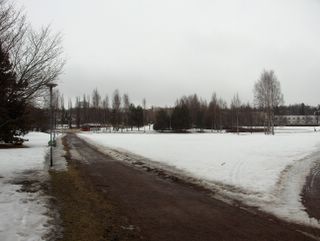
Kevään edistyminen ei ollut vieläkään suurta kuvan tilanteeseen mennessä. Matalapaine oli vallinnut Suomen yllä ja parina edellisenä päivänä etenkin sen länsipuolella tuoden ajoittain lähinnä kuurottaisia sateita. Ilmamassa oli edelleen sen verran viileää, että sateet tulivat osittain lumena ja räntänä. Runsaasta pilvisyydestä (kuvassa oli jälleen runsas sumupilvikerros, koska mm. tuuli oli hyvin heikkoa) johtuen lämpötilojen vuorokausivaihtelu oli yhä pientä; koko kuun alussa tähän asti alin oli -1,9 ja ylin +2,5 astetta. Lumipeite kuitenkin jatkoi sulamistaan ja kuvassa lumipeitteestä oli sulanut jo n. puolet maaliskuussa olleesta n. 30 sentistä. Näin ollen esim. kuvan puistokäytävä oli paljastunut suureksi osaksi. Maa oli kuitenkin vielä jäässä n. 20 - 50 senttiä, jolloin käytävällä ollut kosteus ei päässyt imeytymään kunnolla. Kosteus jäi lilluvaksi märkyydeksi tyypilliseen alkukevään tapaan, kun aurinkokin oli niin vähän esillä. Säätilanne: valitse 4.4.2006; Wetter3 A. Wetter3 B.
The advance of spring still wasn't big until the situation of the picture. A low pressure had been prevailed over Finland and during couple of last days especially in the western side of it bringing occasionally mainly showery precipitation. The air mass was further so cool, that the precipitation came partly in the form of snow and sleet. Due to the plentyfull cloudyness (in the picture there were again abundant layers of stratus clouds, bacause for example winds were very weak) the cycle of night and daytime temperatures was further small; during all of the month to this point the minimum was -1,9 C and the maximum +2,5 C. However the snowcover continued to melt and in the picture about half of the snowcover had been melted of the 30cm amount that was during march. So for example the path in the photo had been exposed for the most part. However the soil was further frozen for about 20 - 50cm and therefore the moisture on the path wasn't able to soak in properly. The moisture was left as a slushy wet layer typically of the early spring, when even the sun wasn't revealing itself much. Weather condition: choose 4.4.2006; Wetter3 A. Wetter3 B.
Helsingin Puistolan säätilasto huhtikuussa 2006 - Weather chart of Puistola, Helsinki in April 2006.
Flickr 1 Flickr 2