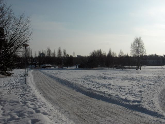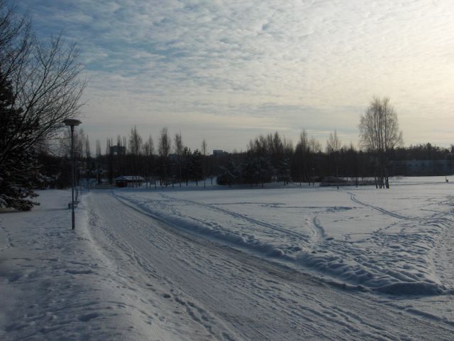
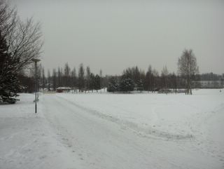
Talvi kiristi vielä tässä vaiheessa otetta, koska edellisinä päivinä länteen muodostuneen vahvan korkeapaineen itäpuolitse virtasi pohjoisesta hyvin kylmää ilmaa koko Suomeen. Kuvauspäivänä Suomen luonaispuolelle oli kehittynyt matalapaine, mutta siitä johtunut hyvin heikko etelätuuli ei säätä lauhduttanut. Yölämpötila oli jopa -18,0 astetta ja päivälämpötila -5,7 astetta. Ainoat merkit lähestyvästä keväästä olivat siten lisääntynyt auringonvalo ja sen myötä suuri lämpötilan vuorokausivaihtelu. Ilmamassa oli tässä vaiheessa hyvin kuivaa ja mantereista. Lumipeite oli ennallaan lisääntyneitä jälkiä lukuun ottamatta. Yksi suojasäähetki 25.2. ei vaikuttanut merkittävästi lyhyytensä vuoksi. Routa (30 - 60cm) lisääntyi hyvin hitaasti paksun lumipeitteen suojaamana kovasta pakkasesta huolimatta. Säätilanne: valitse 28.2.2006; Wetter3 A. Wetter3 B.
At this stage winter strengthened yet the grip, because during previous days very cold air flowed into whole Finland from the north along the eastern side of a strong high pressure formed in the west. At the photoshooting day a low pressure had been formed in the southwestern side of Finland, but very weak southern wind due to that didn't made the weather milder. The night temperature was even -18,0 C and the daytime temperature was -5,7 C. The only signs of the approaching spring were therefore the increased amount of sunlight and a big cycle of the night and daytime temperature due to that. The air mass was very dry and continental at this stage. The snowcover was unchanged not counted for the increased tracks. One moment of thaw at 25th of February didn't had an notable effect due to shortness of it. The soil frost (30 - 60cm) increased very slowly despite the severe frost as protected by the thick layer of snow on the ground. Weather condition: choose 28.2.2006; Wetter3 A. Wetter3 B.Helsingin Puistolan säätilasto helmikuussa 2006 - Weather chart of Puistola, Helsinki in February 2006.Flickr 1 Flickr 2 
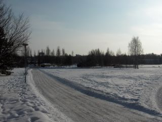
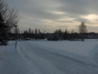
Tässä nähdään pienen matalapaineen rintamapilvien vähentyneen vain untuva-, pallero- ja hahtuvapilvinauhoiksi. Ko. matalapaine oli juuri kulkenut Suomen yli luoteesta kaakkoon. Edellisenä yönä satoi vielä vähän lunta. Sään selkeneminen tiesi aikaisempaa kylmempää seuraavaa yötä ja lämpötila oli alimmillaan myöhään illalla -12,5 astetta. Päivällä aurinko kuitenkin lämmitti jo varsin tehokkaasti ja päivälämpötila olikin ylimmillään -0,1 astetta. Kuvassa nähdään, kuinka auringonvalo oli lisääntynyt verrattuna vastaavaan tilanteeseen kuvassa 28. tammikuuta. Näin leutona päivänä tämä tiesi lumen ja jään selvää sulamista tummilta pinnoilta (kts. albedo), mutta ei vielä muualta. Säätilanne: valitse 22.2.2006; Wetter3 A. Wetter3 B.
In here we see a weather front related clouds of a small low pressure decreased into only stripes of cirrus, cirrocumulus and altocumulus clouds. The low pressure had just been crossed Finland from the northwest to the southeast. During the night before it snowed yet a little. The clearing of the weather meant colder next night than before and the temperature was -12,5 C at lowest late in the evening. However during the day the sun warmed up the air allready fairly effectively and so the daytime temperature was -0,1 at highest. In the picture we see, how the sunlight had been incresed as compared to the similar situation in the photo of the 28th of January. In such a mild day this meant obvious melting of the ice and snow from the dark surfaces (check albedo), but not yet elsewhere. Weather condition: choose 22.2.2006; Wetter3 A. Wetter3 B.Helsingin Puistolan säätilasto helmikuussa 2006 - Weather chart of Puistola, Helsinki in February 2006.Flickr 1 Flickr 2

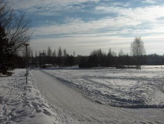
Lumipeite oli säilynyt lähes muuttumattomana kuun alun jälkeen, koska sateita oli tullut hyvin vähän eikä missään vaiheessa ollut suojaa. Lumen lisääntyneiden jälkien lisäksi oli kuitenkin tapahtunut seuraavaa: lumipeite oli tiivistynyt vähän ja sen kiderakenne oli karkeutunut, lumi oli sublimoitunut suoraan vesihöyryksi puiden oksilta ja jäljelle jäänyt lumi oli metamorfoitunut jähmeämmiksi nokareiksi. Taivaalla oli heikon etelässä olleen säärintaman verhopilviä sekä polaariseen ilmamassaan liittyneitä sumupilvikokkareita. Etelätuulet olivat lopulta lauhduttaneet sään -1 asteeseen edelliseksi päiväksi, mutta ko. päivänä kuivempi ja vähän kylmempi ilmamassa alkoi vallata alaa luoteesta käsin vielä lähes tyynessä säässä, kun korkeapaine alkoi työntyä lännestä kohti Suomea. Sen myötä etelän säärintama väistyi ja luoteesta alkoi lähestyä uusi säärintama. Säätilanne: valitse 21.2.2006; Wetter3 A. Wetter3 B.
The snowcover had been stayed allmost unchanged since the start of the month, because there were very little precipitation and it wasn't thaw at any stage. However in addition to the increased tracks of the snow, the following had been happened: the lying snow had been compressed a little and the crystal structure of it had been turned more coarse, the snow had been sublimated straight into water vapour off the trees and the remaining snow had been metamorphed into stiffer lumps. In the sky there were altostratus clouds of a southerly weather front and lumps of stratus clouds related to the polaric air mass. The southerly winds had been turned the weather finally mild to -1 C the day before, but during this day a drier and a little colder air mass started to gain ground from the northwest yet in a near calm weather as a high pressure was moving towards Finland from the west. Due to that the southerly weather front moved away and a new weather front was nearing from the northwest. Weather condition: choose 21.2.2006; Wetter3 A. Wetter3 B.Helsingin Puistolan säätilasto helmikuussa 2006 - Weather chart of Puistola, Helsinki in February 2006.Flickr 1 Flickr 2
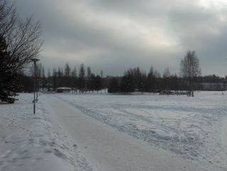
Etelän ja kaakon välinen tuuli oli yltynyt edellisestä päivästä huomattavasti. Kuvassa nähdään tuulen tuomia sumupilviä ja ilmakin oli vähän utuinen, sillä ilmavirtaus toi kosteutta aina Mustaltamereltä asti. Ilmamassa oli kuitenkin varsin kylmää ja lämpötila vaihtelikin päivän aikana -5,6 ja -10,6 asteen välillä. Tuulen ja kosteuden vaikutuksesta ilma tuntui hyvin purevan kylmältä. Lännessä oli tässä vaiheessa laaja matalapaine, mutta kaakon korkeapaine kierrätti edelleen arktista pakkasilmaa etelätuulen sekaan. Tämä aiheutti hyytävän kylmyyden. Säätilanne: valitse 16.2.2006; Wetter3 A. Wetter3 B.
A south-southeasterly wind had been increased prominently from the day before. In the picture we see stratus clouds and the air was also a little hazy, because the air flow brought moisture all the way from the Black Sea. However the air mass was rather cold and so the temperature changed between -5,6 C and -10,6 C during the day. Due to the wind and the moisture the air felt very spikingly cold. At this stage a wide low pressure was in the west, but a high pressure in the southeast circulated further arctic frosty air among the southerly wind. That caused the chilly condition. Weather condition: choose 16.2.2006; Wetter3 A. Wetter3 B.Helsingin Puistolan säätilasto helmikuussa 2006 - Weather chart of Puistola, Helsinki in February 2006.Flickr 1 Flickr 2
 Lunta oli satanut helmikuun alun jälkeen hyvin vähän ja niinpä ainoat muutokset lumipeitteessä havaitaan kuvassa olevien jälkien lisääntymisenä. Hangessa oli mm. hiihtämisestä syntyneitä jälkiä. Sää oli tässä vaiheessa selkeää yksittäisiä sumupilviä lukuun ottamatta. Niinpä lisääntyneen ja voimistuneen auringonvalon ansiosta lumi hohti jo varsin kirkkaasti enteillen lähestyvää kevättä. Samasta syystä lämpötilan vuorokausivaihtelu ilmeni aikaisempaa selvemmin. Aikaisempina päivinä heikot matala- ja korkeapaineet olivat vallinneet ja tässä vaiheessa Suomen kaakkoispuolella oli vahva korkeapaine ja lännessä laaja matalapaine, jolloin kuvan tilanteessa oli viriämässä etelätuulet. Korkeapaine piti edelleen ilman selvästi pakkasella koko ajan, vaikka nyt ei ollut kyse Siperian pakkaskorkeapaineesta. Ko. päivänä lämpötila oli lauhimmillaan -5,6 astetta. Säätilanne: valitse 15.2.2006; Wetter3 A. Wetter3 B.It had been snowed very little after the beginning of the month and therefore the only changes to be seen on the snowcover were the increased tracks in the picture. On the crust of snow there were for example tracks from skeeing. The weather was at this stage clear not counted for the single stratus clouds. Therefore due increased and strengthened sunlight the snowcover glowed allready rather brightly foreseeing the nearing spring. Due to the same reason the cycle of night and daytime temperature was more clearly exposed than before. During previous days weak low and high pressures had been prevailed and at this stage in the southeast was a strong high pressure and in the west a wide low pressure, so winds from the south were picking up. The high pressure kept the air further much freezing all the time, but now at hand wasn't the frosty high pressure of Siberia. During this day the temperature was -5,6 C at the highest. Weather condition: choose 15.2.2006; Wetter3 A. Wetter3 B.Helsingin Puistolan säätilasto helmikuussa 2006 - Weather chart of Puistola, Helsinki in February 2006.Flickr 1 Flickr 2
 Nyt kuvauspaikalle ulottui heikko lumisadealue lounaassa olleesta matalapaineesta. Lunta satoi silti lähes olemattomasti. Pakkanen kuitenkin lauhtui edelleen ollen päivän aikana lauhimmillaan -8,7 astetta. Pilvilajeina taivaalla olivat sadepilvet, mutta tällaisessa pakkasilmassa ne muistuttivat sadepilvien seassa myös olleita sumupilviä ja kumpukerrospilviä; tuloksena oli melko tasaisen harmaa pilvikerros. Tässä kuvassa nähdään myös, kuinka lunta oli edelleen jäänyt alueen havupuihin kuun alun lumisateista, vaikka lumityyppi oli helposti varisevaa pakkaslunta; tässä vaiheessa lumi oli jo tiivistynyt hieman ja sen myötä lumikokkareet olivat vähän jähmeämpiä. Säätilanne: valitse 9.2.2006; Wetter3 A. Wetter3 B.Now a weak area of snowfall had reached the scene from the low pressure situated in the southwest. It snowed allmost nothing though. However the temperature got milder further more and it was -8,7 C at highest during the day. The cloud types in the sky were nimbostratus clouds, but during this kind of frosty weather they resembled stratus clouds and stratocumulus clouds, which were also among the nimbostratus clouds; rather evenly grey layer of clouds was the result. In this picture we see also, how there was snow of the precipitation at the start of the month remaining on the conifer trees of the area, allthough the snow type was easily shattered dry frosty snow; at this phase the snow had been allready compressed a little and due to that the lumps of snow had been turned a bit more stiffer. Weather condition: choose 9.2.2006; Wetter3 A. Wetter3 B.Helsingin Puistolan säätilasto helmikuussa 2006 - Weather chart of Puistola, Helsinki in February 2006.Flickr 1 Flickr 2
 Kuvan tilanteessa tämän talven toinen ankaran pakkasen (lämpötilat -20 ja -25 asteen välillä) jakso oli loppumassa, mutta päivän aikana oli vielä pakkasta -15,0 ja -10,6 asteen välillä. Kuun alussa luoteesta saapunut matalapaine toi yli 5cm uutta lunta, mutta ankaran pakkasen jaksolla 3. - 6. helmikuuta oli pääasiassa selkeää. Routaa (sen syvyys nyt n. 30 - 50cm) oli muodostunut hitaammin kuin edellisen ankaran pakkasjakson aikana maan päällä olleesta runsaammasta lumesta johtuen. Tämän kuvan tilanteessa koillisesta ulottunut Siperian pakkaskorkeapaine ja korkeapaineen alkuvaiheen koillistuulet olivat vaihtuneet kohtalaiseksi etelätuuleksi, mutta lähellä kaakossa ollut korkeapaine piti sään edelleen melko kylmänä. Lauhemman etelätuulen mukana taivaalle oli kuitenkin ilmestynyt hahtuvapilviä (kuvassa), palleropilviä ja kumpukerrospilviä lauttoina. Lännen matalapaineen säärintamat eivät tässä vaiheessa ulottuneet kuvauspaikalle. Säätilanne: valitse 8.2.2006; Wetter3 A. Wetter3 B.In the situation of the photo this winter's second period of severe frost (the temperature between -20 C and -25 C) was ending, but the temperature was yet between -15,0 C and -10,6 C during the day. At the start of the month there fell new snow for more than 5cm, but during the period of severe frost at 3rd - 6th of february it was mostly clear. The soil frost (its depth now about 30 to 50cm) had been formed slower than during the previous period of severe frost due to a bigger amount of snow on the ground. In the situation of this picture the frosty high pressure of Siberia and northeasterly winds at the start of the high pressure had been turned into a moderate southerly wind, but the high pressure near in the southeast kept the weather further rather cold. However layers of altocumulus (in the photo), cirrocumulus and stratocumulus clouds had been appeared in the sky with the milder southerly wind. The weather fronts of a westerly low pressure weren't reaching the scene at this stage. Weather condition: choose 8.2.2006; Wetter3 A. Wetter3 B.Helsingin Puistolan säätilasto helmikuussa 2006 - Weather chart of Puistola, Helsinki in February 2006.Flickr 1 Flickr 2
Kuvassa nähdään hahtuva- ja verhopilvilauttoja. Pilvet liittyivät luoteesta Suomen eteläpuolelle siirtyneeseen matalapaineeseen ja sen kylmään rintamaan. Rintaman jälkeen alkoi vallita hyvin kylmä koillistuuli ja lämpötila laski päivän aikana -6,7 jopa -21,0 asteeseen. Tämän talven toinen ankaran pakkasen jakso oli alkamassa. Mainittu matalapaine toi kahtena edellisenä päivänä yli 5 senttiä uutta lunta, jota nähdään kuvassa tasaisena kerroksena vielä ilman jälkiä. Lumen auraaja oli kuitenkin ehtinyt poistaa lunta puistoväylältä. Lumi tarttui kohtalaisesti paikan havupuihin, kuten havaitaan. Säätilanne: valitse 3.2.2006; Wetter3 A. Wetter3 B.
In the picture we see altocumulus and altostratus clouds in layers. The clouds were associated with the low pressure that was moving from the northwest to the southside of Finland and with a cold front of the low pressure. After the front a very cold northeasterly wind started to prevail and the temperature dropped from -6,7 C to even -21,0 C during the day. The second period of severe frost during this winter was starting. During the previous two days the mentioned low pressure brought more than 5 centimetres of new snow, which can be seen in the picture as an even layer without any tracks as yet. However the snow plower had time to remove the snow from the path of the park. The snow grabbed moderately on the conifer trees of the area as it is seen. Weather condition: choose 3.2.2006; Wetter3 A. Wetter3 B.
Helsingin Puistolan säätilasto helmikuussa 2006 - Weather chart of Puistola, Helsinki in February 2006.Flickr 1 Flickr 2