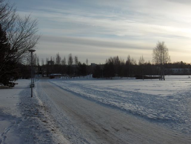
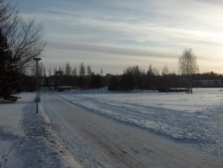
 Melko leuto sää jatkui tässäkin kuvassa. Nyt Etelä-Suomen säähän vaikutti länsiluoteinen Föhntuuli. Lumisadetta oli tullut erittäin vähän edelliseen kuvaan verrattuna, mutta kahden matalapaineen välisen säärintaman untuva- ja harsopilviä oli taivaalla. Kuvassa niiden nähdään juovittuneen ko. säärintaman myötäisesti. Lämpötila oli ylimmillään jopa +0,3 astetta, vaikka taivas oli melko selkeä. Siten tyypillinen Föhntilanne vallitsi; kuivaa, mutta leutoa. Lumi ei kuitenkaan ollut muuttunut suojalumeksi kuivasta ilmasta ja kylmästä maasta johtuen; routaa oli paikoin jo yli 30cm. Säätilanne: valitse 28.1.2006; Wetter3 A. Wetter3 B.A rather mild weather continued also in this picture. Now southern Finland was affected by the west-northwesterly Föhn wind. It had been snowed very little as compared to the previous photo, but the cirrus and cirrostratus clouds of the weather front between two low pressures were in the sky. In the picture we see them lined up according to that weather front. The temperature was even +0,3 C at highest, allthough the sky was rather clear. Therefore it was a typical Föhn condition; dry, but mild. However the snow hadn't been turned into thaw stage due to the drieness of the air and the coldness of the ground; there were soil frost allready locally more than 30cm. Weather condition: choose 28.1.2006; Wetter3 A. Wetter3 B.Helsingin Puistolan säätilasto tammikuussa 2006 - Weather chart of Puistola, Helsinki in January 2006.Flickr 1 Flickr 2
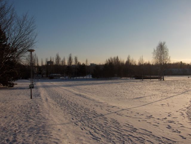
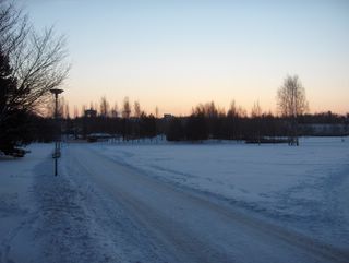 Tässä on hyvä esimerkki sinisestä hetkestä lumisessa tilanteessa, jolloin aurinko on vähän horisontin alapuolella ja taivas tyystin selkeä (vertaa 26.12. otetun kuvan pilvisen sään siniseen hetkeen auringonlaskun jälkeen). Tässä vaiheessa edellisessä kuvassa vallinnut ankara pakkanen oli kuitenkin väistynyt selvästi leudomman sään tieltä; lämpötila kohosi 23. tammikuuta jopa -24,1 asteesta -1,4 asteeseen lounaistuulen myötä. Tämän kuvan ottohetkellä oli vain muutama aste pakkasta ja tilapäisesti selkeää kuivan ja heikon luoteistuulen ansiosta. Uutta lunta oli kertynyt erityisesti ankaran pakkasjakson aikana Suomenlahdella syntyneistä lumikuuroista, mikä on tyypillistä hyvin kylmän pakkasilman virratessa sulan veden yli. Suomenlahti tosin jäätyi suurimmaksi osaksi pakkasjakson aikana. Säätilanne: valitse 26.1.2006; Wetter3 A. Wetter3 B.Here is a good example of the blue moment during a snowy condition, when the sun is just below the horizon and the sky is completely clear (compare to the photo captured in 26th of december, where the blue moment appears in the cloudy weather after the sunset). However at this stage the severe frost of the previous picture had been gone due to a much milder weather; the temperature rose even from -24,1 C to -1,4 C during 23th of january due to a southwesterly wind. At the photographing moment of this picture the temperature was only a few degrees freezing and the sky was temporarily clear due to a dry and weak northwesterly wind. A new snowcover had been formed especially due The Gulf Of Finland born snowshowers during the period of severe frost, which is typical when a very cold frosty air flows over open water. The Gulf Of Finland froze for the most part though during the frosty period. Weather condition: choose 26.1.2006; Wetter3 A. Wetter3 B.Helsingin Puistolan säätilasto tammikuussa 2006 - Weather chart of Puistola, Helsinki in January 2006.Flickr 1 Flickr 2
 Tässä vaiheessa lauha suojasää oli muuttunut kirkkaaksi pakkassääksi. Lämpötilan muutos oli erityisen nopeaa edellisenä päivänä, kun se laski -9,0 asteesta -18,1 asteeseen. Kuvauspäivänä pakkasta olikin sitten jo -17,9 ja -20,3 asteen välillä; tässä vaiheessa talvea aurinko lämmitti päivälämpötilaa muutamalla asteella selkeän sään vuoksi. Rajun kylmenemisen aiheutti koillisesta kohti Suomea työntynyt Siperian ns. pakkaskorkeapaine. Sen myötä hyvin voimakkaiden kaakkois- ja itätuulten mukana myös Etelä-Suomeen saapui kova pakkanen. Kuvauspäivänä tuuli oli kuitenkin jo heikentynyt, mutta pakkanen sen myötä kiristyi entisestään. Kuvassa nähdään kylmenemisen yhteydessä satanutta lunta, joka oli hyvin puuterista ja kuivaa kovasta pakkasesta johtuen. Edellisten päivien kova tuuli pöllytti ko. lunta voimakkaasti eikä se tarttunut ollenkaan puihin. Ohuen lumikerroksen vuoksi routa eteni nopeasti. Säätilanne: valitse 19.1.2006; Wetter3 A. Wetter3 B.At this stage the mild thaw weather had been turned into clear and frosty weather. The drop of temperature was particularly big during the day before, when it plummeted from -9,0 C to -18,1 C. Then during the photoshooting day the temperature was allready between -17,9 C and -20,3 C; at this time of the winter the sun warmed up the daytime temperature for a couple of degrees due to the clear weather. The reason for the severe coldness was a so called frosty high pressure of Siberia, which approached Finland from the northeast. With the high pressure very strong easterly and southeasterly winds brought severe frost also to southern Finland. However during the photoshooting day the winds had been eased, but because of that the frost sharpened further. In the picture we see snow that fell during the drop of temperature. The snow was very powdery and dry due to severe frost. The hard winds of the previous days whirled up this snow and it didn't grab on trees at all. The soil frost increased rapidly due to the thin layer of snow. Weather condition: choose 19.1.2006; Wetter3 A. Wetter3 B.Helsingin Puistolan säätilasto tammikuussa 2006 - Weather chart of Puistola, Helsinki in January 2006.Flickr 1 Flickr 2
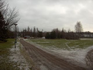
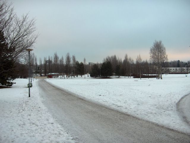
Kuvassa nähdään aikaisemman säätyypin vaihtuneen lauhaksi suojasääksi, joka alkoi 10.1. Ajoittain voimakkaat länsi- ja lounaistuulet toivat myös hieman sateita, jotka tulivat lähes kokonaan vetenä ko. päivinä. Niinpä lumipeite suli lähes kokonaan kuvauspäivään mennessä. Jäljellä oli vain jäisiä laikkuja. Maa oli kuitenkin yhä edelleen useita senttejä jäässä aikaisemmista pakkasista johtuen. Kuvassa vallitsivat sumu- ja kumpukerrospilvet, jotka ovat tyypillisiä näille lauhoille ilmavirtauksille Suomen talvessa. Kuvauspäivänä lämpötila oli ylimmillään +2,3 astetta, mutta oli yöllä tilapäisesti pakkasella (-4,4 astetta) pilvipeitteen oltua vähäinen ja tuulen heikkoa. Keskitalvella myös tuuli säätelee usein keskipäivänkin lämpötilan vaihteluita yön tapaan vähäisen auringonsäteilyn takia; mitä tuulisempaa, niin sitä lauhempaa. Riippuen kuitenkin niiden tuulten kulloinkin tuomasta ilmamassasta; lämpötila voi myös laskea rajusti yöstä keskipäivään mennessä tai lauhtua illan mittaan. Lämpötilan vuorokausivaihtelua ei joka tapauksessa ole usein olemassa loka - helmikuussa, kun se peittyy em. säänvaihteluiden alle edellisen kuvan yhteydessä kerrotusta syystä. Säätilanne: valitse 13.1.2006; Wetter3 A. Wetter3 B.
In the picture we see the change of weather type to a mild thaw, which started at 10th of january. Occasionally strong west and southwesterly winds brought also a little precipitation, which came allmost entirely in the form of rain during those days. Therefore allmost all of the snowcover melted away until the shooting day of the photo. Only icy patches were left. However the soil was still frozen several centimetres deep due to the previous frosts. In the picture the dominating clouds were stratus and stratocumulus clouds, which are typical of these mild airflows during winter in Finland. During the photoshooting day the temperature was +2,3 C at highest, but it was temporarily freezing (-4,4 C) at night due to clearer skies and weaker winds. In midwinter the winds also rule the changes in temperature at noon like at night, because of the minimal amount of the radiation of the sun; the more windy it is the milder it gets. Depending though of the quality of every air mass brought by those winds; it can get dramatically colder as well from night to noon or get milder during the evening. Therefore in any case the cycle of night and daytime temperature doesn't often exist during october - february due to the weather changes and due to the reason as mentioned in the previous picture. Weather condition: choose 13.1.2006; Wetter3 A. Wetter3 B.Helsingin Puistolan säätilasto tammikuussa 2006 - Weather chart of Puistola, Helsinki in January 2006.Flickr 1 Flickr 2

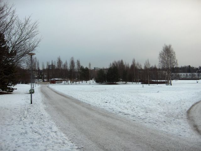
Samanlainen korkeapaine ja heikko pakkanen olivat jatkuneet useita päiviä, mutta kuvauspäivänä leudot länsi- ja lounaistuulet alkoivat vahitellen voimistua. Merkkinä siitä olivat kuvan aikaisempaa runsaammat sumupilvet. Koko päivän oli kuitenkin yhä edelleen pakkasta -6,1 ja -2,8 asteen välillä. Keskitalvella (joulu- ja tammikuussa) korkeapainetilanteessa pilvisyyden aste määrää lämpötilan vaihtelun keskipäivälläkin yön tapaan vähäisen auringonsäteilyn takia; mitä selkeämpää on, niin sitä kylmempää on ilma. Lämpötilan vuorokausivaihtelu katoaa samoin usein pilvisyyden vaihteluiden aiheuttamiin lämpötilan muutoksiin loka - helmikuussa. Lumipeitteen tilanne oli lähes sama aikaisemmasta lähes sateettomasta pakkassäästä johtuen, mutta ihmisten jäljet olivat lisääntyneet. Säätilanne: valitse 9.1.2006; Wetter3 A. Wetter3 B.
The same kind of high pressure and a weak frost had been continued for several days, but in the photoshooting day mild west and southwesterly winds were picking up slowly. As a mark for that there was more stratus clouds in the photo than previously. However the temperature was all day still between -6,1 C and -2,8 C. In midwinter (december - january) during a high pressure the quantity of clouds rule the changes in temperature even at noon like at night, because of the minimal amount of the radiation of the sun; the clearer it is the colder the air gets. Likewise in october - february the cycle of night and daytime temperature often disappears under the changes of temperature caused by the variation of clouds. The condition of the snowcover was allmost unchanged due to the previous frost and allmost no precipitation, but tracks made by people had been increased though. Weather condition: choose 9.1.2006; Wetter3 A. Wetter3 B.Helsingin Puistolan säätilasto tammikuussa 2006 - Weather chart of Puistola, Helsinki in January 2006.Flickr 1 Flickr 2

Kuvan tilanteessa vahva korkeapaine oli vallinnut jo muutaman päivän ajan vuodenvaihteen sateisen ja lauhan jakson jälkeen (etelä- ja lounaistuulet). Pakkanen oli kuitenkin tässä korkeapainetyypissä (keskileveysasteiden ilmamassan korkeapaine) heikkoa ja sumupilvet tyypillisiä. Kuvassa niistä on hyvin ohutkerroksinen esimerkki ja niistä satoi ajoittain hyvin heikosti lunta. Korkeapaineen pohjoispuolitse pääsi Lappiin tyypillisesti suojasääilmaa länsituulten mukana. Pakkanen oli kuvauspaikalla päivän aikana -2,2 ja -0,7 asteen välillä. Vuodenvaihteen lauhat säät toivat suojasään, mutta samalla myös lisää lunta. Niinpä lumipeite säilyi edelleen. Aikaisemmasta märästä suojasäästä on kuvassa merkkinä jäiseksi jäätynyt puistokäytävä. Säätilanne: valitse 6.1.2006; Wetter3 A. Wetter3 B.
In the picture a strong high pressure had been dominated for a couple of days after a rainy and mild period at the turn of the year (south and southwesterly winds). However the frost was weak in this type of high pressure (the high pressure of the middle latitude air mass) and stratus clouds were typical. Very thin layered example of those are shown in the picture and they gave very slight snowing from time to time. Along the northern side of the high pressure a mild thaw air flowed typically into Lapland from the west. At the photoshooting scene the temperature was between -2,2 C and - 0,7 C during the day. The mild weather at the turn of the year brought thaw, but also more snow. Therefore the snowcover remained further. As a mark for the previous wet thaw the path is frozen icy in the photo. Weather condition: choose 6.1.2006; Wetter3 A. Wetter3 B.
Helsingin Puistolan säätilasto tammikuussa 2006 - Weather chart of Puistola, Helsinki in January 2006.Flickr 1 Flickr 2