
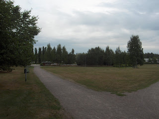
Edellisenä iltana ja yönä Mustanmeren pohjoispuolella kehittyi nopeasti voimakas matalapaine, joka liikkui kuvauspäivänä lähelle Suomen kaakkoispuolelle. Matalapaine kehittyi Länsi- ja Keski-Euroopan viileän ilmamassan kohdattua Kaspianmeren pohjoispuolen erittäin kuuman ilmamassan. Lämmin ilma virtasi matalapaineen mukana pohjoiseen kauempana Venäjällä. Suomi jäi vähän viileämmän ilmamassan puolelle (edelleen kuitenkin vähän tavanomaista lämpimämpi; päivälämpötila +21,0 astetta) ja ko. matalapaineen voimakas ja vaihteleva rintamasysteemi hipoi kaakkoista Suomea illalla. Samalla koillistuuli voimistui ajoittain jopa navakaksi, mutta sateita ei kuvauspaikalle ulottunut. Kuvassa tähän rintamasysteemiin kehittyneen voimakkaan sadealueen etummaiset pilvet saapuivat silti kuvausalueellekin mahtavina rintaman suuntaisina raitoina. Pilvilajit olivat tyypillisesti etummaisena untuva- ja harsopilvet ja taivaanrannassa verhopilvet. Tilanne oli erinomainen näyttävälle iltaruskolle kuvauksen aikana, koska kuvaan verrattuna vastakkainen auringon laskun taivas oli lähes selkeä. Iltaruskon aikaistuminen ko. aikatauluun merkitsi syksyn tunnun voimistumista. Kasvillisuus pysyi kuitenkin kesäisen vihreänä yksittäisiä varhaisia ja vähäisiä syysvärejä lukuun ottamatta, koska pitkän kuivuuden jälkeen kasvit pyrkivät käyttämään vielä täysipainoisesti uutta kosteutta hyväkseen; ruska ei siis lähtenyt käyntiin kunnolla edes varhaisipien lajien ja kasvupaikkojen suhteen Etelä-Suomessa. Tähän vaikutti myös edelleen tavanomaista lämpimämpänä jatkunut sää. Sen takia kesä jatkui selvästi myös määritelmän mukaan; kesä on, kun vuorokauden keskilämpötila on yli +10 astetta. Edellinen yö oli kuitenkin melko viileä (+7,6 astetta), koska sää oli tyyntä ja selkeää ilmamassan oltua edellisiä öitä myös kuivempaa; yöllä ja aamulla oli vain vähän usvaa. Kuun lopun sateet imeytyivät kuivaan maahan niin hyvin, että sateilla oli vielä vain vähän vaikutusta poikkeuksellisen alas laskeneisiin pohjavesiin ja muihin vesistöihin. Sisämaan runsassateisilla alueilla vaikutus oli suurin, mutta järvien ja jokien pinnat olivat sielläkin vielä enimmäkseen tavanomaisen tason alapuolella. Säätilanne: valitse 30.8.2006; Wetter3 A. Wetter3 B.During the previous evening and night there formed quickly a strong low pressure in the northern side of Black Sea and during the photoshooting day it moved close to the southeastern side of Finland. The low pressure was formed as the cool air mass over western and central Europe met the very hot air mass in the northern side of Caspian Sea. The warm air flowed along the low pressure to the north further away in Russia. Finland remained in the side of a little bit cooler air mass (however further a bit warmer than on an average; the afternoon temperature +21,0 C) and a strong and variable frontal system verged on the southeastern corner of Finland during the evening. At the same time a northeasterly wind picked up occasionally into fresh stage, but there didn't reach rain into the photoshooting scene. In the picture the foremost clouds of the heavy precipitation area associated with the frontal system reached also the photoshooting scene though as an enormous stripes along with the direction of the front. The cloud types were typically as in the foremost cirrus and cirrostratus clouds and in the horizon altostratus clouds. The situation was excellent for a showy sunset colours during the photoshoot, because as compared to the picture the opposite sun setting sky was allmost clear. The sunset colours being in this earlier timetable meant increasing feeling of autumn. However the vegetation remained summery green not counted for single and minor fall colours, because after the drought the plants were trying to take advantage of the new moisture in a full bodied way; so the fall colours didn't start to appear even considering the earliest plants and localitys in southern Finland. In here there was affecting also the weather continuing further warmer than usually. Due to that the summer continued also according to the definition (in Finland); summer is, when the daily average temperature is over +10 C. However the last night was rather cool (+7,6 C), because the weather was calm and clear as the air mass was also drier than in the previous nights; only little amounts of mist during the night and morning. The rains of the latter part of the month absorbed into the dry ground so well, that the rains had yet only little influence to the unusually low ground waters and to other water areas. The influence was the biggest in the inland areas of profuse precipitation, but the levels of lakes and rivers were also there mainly lower than the usual level. Weather condition: choose 30.8.2006; Wetter3 A. Wetter3 B.Helsingin Puistolan säätilasto elokuussa 2006 - Weather chart of Puistola, Helsinki in August 2006.Flickr 1 Flickr 2Tehoisa lämpösumma - The Effective Temperature Sum: 1375,7

Kuun 27. päivänä vallitsi aluksi edellisen tilanteen kaltainen aamu-usvainen, heikkotuulinen ja kuurosateinen (edelleen paikoin ukkostakin) sää, jossa paikallaan seisonut ilmamassa oli lämmintä; päivälämpötilat olivat eteläisessä Suomessa yli +20 astetta pilvistä huolimatta. Islannin eteläpuolelle oli voimistunut matalapaine 25. päivän tienoilla ja yksi osakeskus muodostui 27. päivänä Etelä-Skandinaviaan. Nämä kaksi yhdistyivät 28. päivänä isoksi matalapaineeksi, jonka keskus oli edelleen Etelä-Skandinavian yllä myös kuvauspäivänä. Tähän liittyen edellisenä päivänä ja yönä okluusiorintama liikkui hitaasti eteläisen Suomen yli pohjoiseen. Siinä yhteydessä kuurottaisia sateita ja edelleen paikoin ukkosta tuli melko runsaasti. Kuvauspäivänä rintaman jälkeen tuli edelleen sadekuuroja ja kohtalainen kaakkoistuuli oli kääntynyt lounaaseen ja heikentynyt. Ilmamassa viileni vähän ja päivälämpötilat jäivät jo edellisenä päivänä n. +20 asteeseen. Suomen kaakkois- ja itäpuolelle ulottui silti edelleen hyvin lämmintä ilmaa virranneena Kaspianmeren pohjoispuolen erittäin kuumalta alueelta. Em. iso matalapaine tiesi sijaintinsa takia samalla myös Länsi- ja Keski-Euroopan säilymistä edelleen varsin viileänä (Espanjaan ulottui Afrikasta erittäin kuumaa ilmaa). Tämä matalapaine oli tavallaan syksyn ensimmäisiä merkkejä (kesän matalapaineet ovat Euroopassa yleensä pienialaisia), mutta kesälle tyypillinen piirre oli edelleen em. kuurosateiden paikalliset suuret vaihtelut; joillakin paikoilla satoi runsaasti, mutta esim. Puistolan sääasemalla runsaita sademääriä ei kertynyt. Kuvassa nähdään oikealla taivaanrannalla eräs kypsään vaiheeseen kehittynyt kuuropilvi. Sää oli poutaantumassa tässä vaiheessa ja tuokin kuuro oli heikkenemässä ja katoamassa. Lämpimän meren (vähän vajaa +20 astetta) takia näitä kuuroja esiintyi merenkin yllä, kun merituulta ei enää ollut. Osa kuuroista säilyi öisinkin meren yllä (Itämerellä edellisenä yönä) paljon elinvoimaisempina kuin sisämaa-alueilla. Tämä on tyypillinen loppukesän - alkusyksyn piirre lämpimän meren takia. Kuvausalueen kasvillisuus toipui edelleen kesän ennätyskuivuudesta ja nyt rannikollakin oli satanut sen verran, että erot sisämaan ja rannikon välillä olivat tasoittumassa. Maaperä ei kuitenkaan ollut kastunut vielä läpikotaisin tai takaisin normaaliin tilaan, mutta paikallisia vaihteluita oli; kallioiset mäet imivät vettä parhaiten. Kuvan nurmikkoa ei oltu vieläkään leikattu uudestaan. Leikkaustauko oli siten jo yli kahden kuukauden mittainen ja siten ennätysmäinen huikealla tavalla. Nyt nurmikosta havaittiin myös se, että jotkut kohdat olivat kuolleet kuivuuden takia kokonaan, kun vihreys ei palannut kunnolla joka kohtaan. Säätilanne: valitse 29.8.2006; Wetter3 A. Wetter3 B.During the 27th day there prevailed at first the same kind of morning misty, weakly windy and showery (further also local thunder) weather, where the air mass lingering in place was warm; the afternoon temperatures were over +20 C in southern Finland despite the clouds. There had been strengthened a low pressure in the southern side of Iceland around the 25th day and a small subcenter was formed in southern Skandinava during the 27th day. These two fused together during the 28th day to form a big low pressure, which center was further over southern Skandinavia during the photoshooting day as well. As associated with this there moved a occluded front slowly over southern Finland to the north during the previous day and night. Along with that there came showery rain and further locally thunder rather profusely. During the photoshooting day after the front there came further showers and a moderate southesterly wind had been turned to southwest and weakened. The air mass cooled a bit and the afternoon temperatures remained allready in the previous day at about +20 C. There reached very warm air to the southeastern and eastern side of Finland though as flowed from the very hot area in the northern side of Caspian Sea. The mentioned big low pressure meant due to its location also at the same time western and middle Europe remaining rather cool (there reached very hot air into Spain from Africa). This low pressure was in a way one of the first signs of autumn (low pressures of summer are in Europe usually small sized), but a feature typically summery was further the big local differences of the mentioned showers; in some places there rained plentyfully, but for example at the weather station of Puistola there didn't accumulate big amounts of precipitation. In the picture we see on the right in the horizon one shower- / cumulonimbus cloud as progressed into a mature stage. The rains were moving away at this stage and that cumulonimbus cloud was also weakening and disappearing. Due to the warm sea (a bit under +20 C) these showers appeared over the sea as well, because there wasn't a sea breeze anymore. A part of the showers remained also at nights over the sea (over Baltic Sea during the last night) much more vitally than over inland areas. This is a typical feature of late summer - early autumn due to the warm sea. The vegetation of the photoshooting region recovered further from the summer's record breaking drought and now also by the coast there had been rained in such a way, that the differences between inland areas and the coast were becoming more level. However the ground wasn't wetted thoroughly yet or back to a normal stage, but there were local differences; rocky hills absorbed the water the best. The lawn in the picture wasn't being mowed again even now. Therefore the pause in the mowing was now more than two months long and so record breaking in a enormous way. Now one was able to observe from the lawn, that some spots had been died completely due to the drought, as the green colour didn't return properly in every spot. Weather condition: choose 29.8.2006; Wetter3 A. Wetter3 B.Helsingin Puistolan säätilasto elokuussa 2006 - Weather chart of Puistola, Helsinki in August 2006.Flickr 1 Flickr 2Tehoisa lämpösumma - The Effective Temperature Sum: 1365,1

Ilmamassa oli nyt kosteampaa kuin edellisessä tilanteessa. Suomen eteläpuolella ollut matalapaine kuitenkin heikkeni ja levisi epämääräiseksi osaksi laajaa Atlantille ulottunutta matalapainetta, mutta lämpimien itä - kaakkoistuulten tyynnyttyä kuvauspäiväksi kosteus tuntui ja säilyi aikaisempaa paremmin. Osasyy siihen oli myös jo selvästi heikentynyt auringon teho syksyä enteillen (vielä oli kuitenkin kesä). Näiden takia esim. edellisenä ja seuraavana yönä esiintyi yleisesti usvaa ja sumua. Sää pysyi edelleen kuitenkin tavanomaista lämpimämpänä, kun ilmamassa jäi matalapaineen heikkenemisen takia paikalleen; Etelä-Suomen päivälämpötilat olivat edellisen tilanteen jälkeen +20 ja +25 asteen välillä huolimatta ko. päivien ajoittain runsaasta pilvisyydestä. Öisin oli vähän yli +10 astetta ja etelärannikolla paikoin n. +15 astetta, koska Suomenlahti pysyi tavanomaista lämpimämpänä (paikoin n. +20 astetta matalissa rantavesissä). Järvienkin vedet olivat edelleen sen verran lämpimiä (n. +20 astetta), että olosuhteet olivat vielä kelvolliset uimiseen. Em. lämpö ja kosteus ilmenivät tässä vaiheessa vielä kesälle tyypilliseen tapaan; molempina iltapäivinä edellisen tilanteen jälkeen esiintyi runsaasti sadekuuroja ja paikoin ukkosta. Merituulella ei ollut enää juuri vaikutusta, joten esim. kuvauspäivänä kuuroja ja ukkosta esiintyi myös kuvauspaikalla ja muuallakin etelärannikolla. Kuvassa eräs ukkossolu oli aivan lähellä kuvan vasemmassa reunassa, jossa ko. kuuropilveä näkyy tummana alueena. Hetkeä aikaisemmin paikalla oli rankkoja, mutta lyhyitä kuuroja. Kuvan tilanteessa kuuropilvi oli jo heikkenemässä (se havaitaan kuvassa kuuropilven laajentumisena verhopilvien suuntaan), mutta pari kertaa kuului vielä jyrinää kuvan ottamisen jälkeen. Ko. paikalla ukkosta oli koko kesänä kunnolla vasta nyt ja se kuvasti hyvin kesän ennätyskuivuutta. Välittömästi ennen kuvan ottamista olin matkalla Hämeenlinnasta ko. paikalle ja matkalla voimakkain ukkossolu oli n. 20 - 40 km Helsingistä pohjoiseen. Kuvan nurmikko jatkoi edelleen elpymistään ja suurin osa alasta oli jo vihreänä. Missään ei oltu kuitenkaan vielä aloitettu uudestaan nurmikoiden leikkaamista lukuun ottamatta hyvin yksittäisiä kosteimpia alueita. Sisämaassa aikaisemmat runsaammat sateet vaikuttivat silti niin, että siellä nurmikoita leikattiin uudestaan jo normaaliin kesäiseen tapaan. Yhä lisääntynyt kosteus tiesi myös sitä, että etuajassa ilmestyneiden syysvärien lisääntyminen loppui ja yleensäkin vain hieman - kohtalaisesti kuivuudesta kärsineiden puiden ja pensaiden voinnit alkoivat selvästi kohentua, missä niiden ulkonäöt muuttuivat vielä varsin kesäisiksi. Säätilanne: valitse 26.8.2006; Wetter3 A. Wetter3 B.The air mass was now more moist than in the previous situation. However the low pressure in the southern side of Finland weakened and spreaded into a indefinite part of the wide low pressure area reaching Atlantic, but as the easterly - southeasterly winds calmed down until the photoshooting day, the humidity was being felt and remained better than before. A partial reason for that was also allready the clearly decreased power of the sun foreseeing the autumn (it was yet summer though). Due to these there appeared commonly mist and fod during the previous and the following night. However the weather stayed further warmer than the average, because the air mass remained in place after the low pressure weakened; the afternoon temperatures of southern Finland were after the previous situation between +20 C and +25 C despite the cloudyness being occasionally dense during those days. At nights there were a bit more than +10 C and by the southern coast locally about +15 C, because The Gulf Of Finland remained warmer than the average (about +20 C in low shore waters). The waters of lakes as well remained warm in such a way (about +20 C), that conditions for swimming were yet suitable. The mentioned humidity and warmth appeared at this stage yet in a way typical of summer; during both afternoons there appeared plenty of showers and local thunder after the previous situation. The sea breeze didn't have hardly any influence anymore, so therefore there appeared showers and thunder for example in the photoshooting scene as well and elsewhere by the southern coast. In the picture one cell of thunder was quite near on the leftside of the picture, where the cumulonimbus cloud in question is seen as the dark area. A moment ago there was heavy, but breaf showers in the scene. In the situation of the picture the cumulonimbus cloud was allready weakening (it is observed in the picture from the cloud spreading into the direction of altostratus clouds), but there was yet sounds of thunder to be heard for couple of times after the photoshoot. In this place there was properly thunder only just now during the whole summer and it was reflecting well the summer's record breaking drieness. Immediately before the photoshoot i was travelling from Hämeenlinna to this scene and during the trip the strongest cell of thunder was about 20 - 40 kilometres north from Helsinki. The lawn in the picture continued further the recovering and most of the area was allready green. However there hadn't yet been started the mowing of the lawns nowhere again not counted for very single most moist areas. In inland areas though the previous more profuse rains influenced in such a way, that over there the lawns were being mowed again in the normal summery way. The further increased moisture meant also the fact, where increasing of the fall / autumn colours stopped and also in general the conditions of only a bit - moderately drought harmed trees and shrubs started to be clearly better in the way, where their appearances transformed yet into a rather summery stage. Weather condition: choose 26.8.2006; Wetter3 A. Wetter3 B.Helsingin Puistolan säätilasto elokuussa 2006 - Weather chart of Puistola, Helsinki in August 2006.Flickr 1 Flickr 2Tehoisa lämpösumma - The Effective Temperature Sum: 1329,7
Edelliseen päivään verrattuna kaakossa kehittynyt uusi matapaine siirtyi kuvauspäivänä lähemmäksi Suomen eteläpuolelle. Matalapaine oli osa pitkälle Atlantille ulottuvaa pienten matalapaineiden sarjaa, joka kehittyi edellisten päivien aikana. Sen myötä etenkin Länsi-Eurooppa (paitsi Espanja) pysyi viileänä, mutta ensin mainittu matalapaine kierrätti Suomeen edelleen ajankohtaan nähden melko lämmintä ilmaa idästä ja kaakosta (kuumat ilmamassat olivat yhä Kaspianmeren pohjoispuolella); ko. päivän ylin lämpötila oli +24,0 astetta. Matalapaineeseen liittyi okluusiorintama, joka saapui kuvauspäivänä eteläisen Suomen ylle. Siihen liittyi runsasta pilvisyyttä, josta kuvassa olivat esimerkkinä verhopilvet ja tummemmat kumpukerrospilvet. Sateet pysyivät kuitenkin lähellä matalan keskusta melkein kokonaan Suomen eteläpuolella. Niinpä kuvan ottamiseen mennessä ei satanut yhtään ko. paikalla. Tässä kuvassa nähdään selvemmin, kuinka tuo nurmikko oli alkanut elpyä viime päivien sateiden ansiosta. Kuvan lehtipuut olivat edelleen kesäisen vihreitä, mutta tuore kosteus ei vaikuttanut vielä kunnolla puiden kuivuuden aiheuttamiin vaivoihin. Lehtien kellastumista tapahtui siten vielä joillakin ns. puolikuivilla paikoilla (kuivimmilla paikoilla moni puu oli jo valetalvilevossa tai kuollut, kuten edellisessä merkinnässä käy ilmi), missä kellastuminen oli tässä vaiheessa jo tavallaan syysvärejä. Varsinainen ruska oli siis alkanut etuajassa yksittäisillä paikoilla. Kasvukauden lämpösumma saavutti tässä vaiheessa tällä alueella sen arvon (n. 1300), joka normaalisti saavutetaan kasvukauden päätteeksi lokakuussa. Sen mukaan kasvukausi oli nyt edellä normaalista aikataulusta jopa yli kuukauden. Kasvun kehitysastetta arvioimalla kasvun etumatka oli kuitenkin keskimäärin vähän alle kuukauden. Kuivuuden takia paikalliset vaihtelut olivat kuitenkin edelleen äärimmäisiä (etenkin etelärannikolla), koska kuivilla kasvupaikoilla kasvit olivat olleet osaksi lepotilassa jo pari - kolme viikkoa. Normaalistikin kasvun astetta on vaikea määritellä tarkasti kasvukauden lopussa, kun kasvillisuus näyttää kasvunsa lopussa pitkän aikaa melko samannäköiseltä ennen syysvärejä. Nyt tuo aikajakso oli poikkeuksellisen pitkä kotimaisten kasvien parissa lämmön takia. Kosteilla alueilla huikea lämpökertymä näkyi parhaiten tietyissä ulkomaisissa lämpöä vaativissa lajeissa (joilla on Suomen oloissa vielä myöhäisiä ja selviä kasvuvaiheita) joissakin puistoissa ja puutarhoissa; esim. jalopähkinöiden (Juglans sp.) tämän kesän isot versot olivat jo pääosin loppuun puutuneita ja mustaseljan (Sambucus nigra) marjat kypsyneitä. Lisääntynyt maan kosteus olisi näkynyt tässä vaiheessa myös öiden ja aamujen kasteen ja sumujen lisääntymisenä myös yhä pimenneiden öiden takia, mutta voimistuneet itätuulet estivät niiden esiintymisen ja ilmamassakin oli melko kuivaa; ei ollut kunnolla edes utua. Säätilanne: valitse 24.8.2006; Wetter3 A. Wetter3 B.As compared to the previous day the low pressure formed in the southeast moved closer to the southern side of Finland during the photoshooting day. The low pressure was a part of a series of small low pressures reaching far Atlantic, which formed during previous days. Therefore especially western Europe (Spain not included) remained further cool, but the firstly mentioned low pressure circled further rather warm air considering the time of the year into Finland from the east and southeast (hot air masses were still in the northern side of Caspian Sea); the maximum temperature of the day was +24,0 C. There was associated an occluded front with the low pressure and it arrived over southern Finland during the photoshooting day from the southeast. There was related plentyfull cloudyness with it and there are altostratus and darker stratocumulus clouds in the picture as examples of that. However the precipitation remained near the low pressure center allmost completely in the southern side of Finland. Therefore there didn't come any rain until the photoshooting moment in this place. In this picture we see more clearly, how that lawn had been started to recover thanks to the rains in recent days. The broadleaf trees in the picture were further summery green, but the fresh moisture didn't have yet a proper effect to the trees troubles caused by the drought. Therefore leaves were yet turning yellow in so called half dry places (in the most dry places many trees were in a pseudo winter dormancy or dead, as it is revealed in the previous post), where the leaves turning yellow was at this stage in a way the first fall / autumn colours. So the period of true fall colours had been started ahead of schedule in single places. The temperature sum of the growing season reached at this stage in this region the value (about 1300), which is normally reached at the end of the growing season in October. According to that the growing season was now even more than a month ahead of the normal schedule. However when evaluating the stage of growth the advance of growth was a bit less than a month of the average. However due to the drought the local differences were further extreme (especially by the southern coast), because a part of the plants in the dry localitys had been in dormancy for two to three weeks allready. Also normally it is hard to evaluate sharply the stage of the growth at the end of the growing season, because the vegetation appear rather same looking for a long time at the end of the growth before fall colours. Now that period of time was unusually long among native plants due to the warmth. However in moist areas the enormous amount of growth appeared the best among certain foreign species requiring warmth (which have yet late and clear growing phases in the circumstances of Finland) in some parks and gardens; for example this summers big shoots of Walnuts (Juglans sp.) were allready completely turned woody for the most part and berries of Common Elderberry (Sambucus nigra) were ripened. The increased ground moisture would have been showed at this stage as increasing of dew and fogs during nights and mornings also due to the further darkened nights, but the strengthened easterly winds prevented them from appearing and the air mass was also rather dry; there wasn't properly even haze. Weather condition: choose 24.8.2006; Wetter3 A. Wetter3 B.Helsingin Puistolan säätilasto elokuussa 2006 - Weather chart of Puistola, Helsinki in August 2006.Flickr 1 Flickr 2Tehoisa lämpösumma - The Effective Temperature Sum: 1303,3

Ilmamassa pysyi yhä lämpimänä; iltapäivälämpötilat olivat n. +25 astetta joka päivä monin paikoin, joten kesän kahdeksas helleaalto oli käynnissä. Öisin oli vähän päälle +10 astetta, mutta 22. päivän yönä kohtalaisen kaakkoistuulen ja runsaan pilvisyyden takia jopa yli +15 astetta laajalla alueella. Ilmamassa ei päässyt vaihtumaan viileämpään seuraavan takia; kuun 19. ja 20. päivinä Britteinsaarilla ollut matalapaine heikkeni ja siitä erkani itään Suomen eteläpuolelle pieni osakeskus. Samalla Pohjois-Skandinavian (Lapin) ylle muodostui korkeapaine ja aluksi eteläinen Suomi oli heikon korkean selänteen alueella. Ko. päivinä eteläisen Suomen tuulet olivat koko ajan hyvin heikkoja; länsituulet vaihtuivat vähitellen itätuuliksi. Vähäisiä sadekuuroja tuli vielä 19. päivänä etenkin sisämaassa, mutta muutoin vallitsivat lähinnä vain kumpukerros-, hahtuva- ja kumpupilvet vaihtelevasti. Etelä- ja pohjoispuolilla olleet rintamat ulottivat myös untuva- ja harsopilviään esim. tarkastelupaikalle. Sitten kuvausta edeltävään päivään asti Britteinsaarilta Suomen eteläpuolitse Venäjälle ulottuva matalapaine sai Atlantin rintamista ja matalapaineista ajoittain lisävoimaa, jolloin siihen liittyneitä rintamia saapui etelästä ja ne asettuivat pariksi päiväksi eteläisen Suomen lähelle. Samalla kaakkoistuulet toivat yhä lämmintä ilmaa ja kuurottaisia sateita paikallisine ukkosineen esiintyi eteläisen Suomen alueella ja vihdoin etelärannikollakin saatiin paikoin runsaasti sadetta. Kuvauspaikalla sateet jäivät kuitenkin korkeintaan kohtalaisiksi eikä ukkostakaan ollut. Pohjoiseen muodostunut korkeapaine esti rintamaa etenemästä pohjoiseen ja kuvauspäivänä se jäi Suomen etelä- ja lounaispuolelle kaakossa voimistuneesta uudesta matalapaineesta huolimatta. Niinpä edellisten päivien ajoittain runsas pilvisyys vaihtui kuvauspäiväksi vähäisempiin untuva- ja harsopilviin, joita nähdään kuvassa kilpimäisinä kerroksina. Kuvassa näkyy selvästi myös se, kuinka edellisten päivien sateet alkoivat jo vaikuttaa alueen nurmikoihin elvyttävästi; vihreys palasi laikuittain ja tavallaan nurmikoille oli alkamassa vuoden toinen kesä. Puuvartisiin kasveihin ko. sademäärät eivät vaikuttaneet vielä merkittävästi, koska kuivuus oli edennyt niin syvälle maahan; vasta muutama sentti pintaa oli kastunut hieman. Sisämaan runsassateisilla alueilla vaikutus oli kuitenkin jo havaittavaa; lehtien kellastuminen loppui. Sateilla ei sen sijaan ollut enää juuri vaikutusmahdollisuutta kallioisten mäkien puihin ja pensaisiin etelärannikolla, missä moni puu oli kuivunut kokonaankin ruskeiksi tai varistanut jo kaikki lehtensä kuivuuden takia. Osa ko. mäkien männyistä (Pinus sylvetris) oli edelleen vähän - kokonaan ruskeita. Ruskean kuivumisvärin määrästä saattoi arvioida havupuiden toipumiskykyä; tietyn rajan jälkeen runsaatkaan sateet eivät juuri pelasta yli puoleksi ruskeaksi kuivuneita. Kallioisilla mäillä niitä oli paikoin runsaasti etenkin taimissa. Venäjän metsäpalojen savut tulivat jälleen Etelä-Suomeen kaakkoistuulten takia ja 21. päivänä savujen tiheys saavutti etelärannikolla kesän ennätyksen; olosuhteet olivat jopa lähes sumuiset. Kuvauspäivänä tuulten kääntyminen itään sai savut jäämään Suomen eteläpuolelle. Säätilanne: valitse 23.8.2006; Wetter3 A. Wetter3 B.The air mass remained further warm; the afternoon temperatures were every day about +25 C in many places, so the eighth heatwave of the summer was ongoing. There was a bit over +10 C at nights, but in the night of the 22nd day there was even more than +15 C in a wide area due to a moderate southeasterly wind and plentyfull clouds. The air mass wasn't able to change into a cooler air mass due to this; during the 19th and 20th days the lowpressure over British Isles weakened and there departed a small subcenter from it to the east in the southern side of Finland. At the same time there formed a high pressure over northern Skandinavia (Lapland) and at first southern Finland was in the area of a weak ridge of high pressure. During both days the winds of southern Finland were all the time very weak; westerly winds turned cradually to easterly winds. There came yet minor showers during the 19th day especially in inland areas, but otherwise there prevailed mainly just stratocumulus, altocumulus and cumulus clouds in variable ways. Fronts in the northern and southern sides distributed their cirrus and cirrostratus clouds as well for example into the observing scene. Then the low pressure reaching from British Isles into Russia via southern side of Finland received oocasionally extra power from fronts and low pressures over Atlantic and so fronts associated with that arrived from the south and they settled near southern Finland for couple of days. At the same time southeasterly winds brought still warm air and showery rains with local thuder appeared in southern Finland and at last also by the southern coast there came locally profuse amounts of rain. However in the photoshooting scene the precipitation was only moderate at the most and there wasn't thunder either. The high pressure formed in the north prevented the front to move northwards and during the photoshooting day it remained in the southern and southwestern side of Finland. Therefore until the photoshooting day the occasionally dense cloudyness of the previous days changed into lesser cirrus and cirrostratus clouds, which are seen in the picture as shield-like layers. In the picture there is clearly visible also the fact, how the rains of the previous days started to affect to the lawns of the region in a reviving way; the green colour returned in spots and in a way there was beginning a second summer of the year for the lawns. Woody plants weren't affected considerably by these amounts of precipitation yet, because the drought had been progressed so deep into the ground; only couple of centimetres of the surface had been wetted a little. However in the areas of profuse rains in inland the affection was allready notable; the leaves stopped from turning yellow. As opposed to that the rains didn't have an influence anymore to the trees and shrubs in rocky hills by the southern coast, where many trees were dried even completely brown or dropped their all leaves allready due to the drought. A part of Scots Pines (Pinus sylvetris) in those hills were further a bit - completely brown. From the amount of the brown drying up colour one was able to estimate the recovering ability of the conifer trees; after a certain level even heavy rains aren't hardly able to rescue the trees dried up brown more than halfway through. In rocky hills there was locally a lot of them especially among young plants. The smokes of the forest fires in Russia came again into southern Finland due to the southeasterly winds and during the 21st day density of the smokes reached the record of the summer by the southern coast; circumstances were even allmost foggy. During the photoshooting day turning of the winds to the east got the smokes to remain in the southern side of Finland. Weather condition: choose 23.8.2006; Wetter3 A. Wetter3 B.Helsingin Puistolan säätilasto elokuussa 2006 - Weather chart of Puistola, Helsinki in August 2006.Flickr 1 Flickr 2Tehoisa lämpösumma - The Effective Temperature Sum: 1289,8

Edellisenä päivänä Euroopassa vallitsi edelleen tilanne, jossa pitkä matalapaineen alue ulottui läntisestä Euroopasta Suomen yli Venäjälle. Siihen liittyen voimakkain matalan keskus pyöri Britteinsaarten lounaiskulmalla. Sen ansiosta helle alkoi voimistua itäisessä Euroopassa (Länsi-Eurooppa pysyi edelleen viileänä ja kuumimmat ilmamassat olivat olleet jo useita päiviä kaukana Mustanmeren ja Kaspianmeren välissä) ja Etelä-Suomessakin ilmamassa pysyi tavanomaista lämpimämpänä, vaikka päivälämpötilat jäivät nyt vähän alle +25 asteen. Pilvien ja tuulten takia yöt olivat lämpimiä ja esim. edellisen päivän yönä alin lukema oli +16,3 astetta, kun lounaistuuli oli melko voimakasta pienen matalapaineen takia. Kuvauspäivänä Suomen ylle jäi heikkenevä matalapaine ja edellisen päivän lounais - länsituulet heikkenivät. Molempina päivinä esiintyi kuitenkin loppukesälle tyypilliseen tapaan runsaasti sadekuuroja ja paikoin ukkosta, mutta lähinnä vain sisämaassa. Kuuroja ehkäisevä merituuli ilmeni heikosti lämpimästä merestä huolimatta. Niinpä kuvassa oli vain vähän hahtuva - kumpupilviä, mutta kuvaajan vasemmalla puolella ja selän takana kuuropilviä oli ajoittain lähellä. Viron puolella olleita kuuropilvien huippuja näkyi kuvassa kaukana horisontissa. Kuurot olivat tyypillisesti voimakkaimmillaan iltapäivällä ja öisin ne olivat melkein kadonneita. Kuurojen ansiosta eteläisen Suomen sisämaan kuivuus helpotti edelleen monin paikoin, mutta tällä alueella hyvin minimaalisten kuurojen takia nurmikoiden kasvu ei vieläkään alkanut uudestaan. Kuivuus näkyi edelleen mm. kuvan keskeltä vähän vasemmalle olevissa rauduskoivuissakin (Betula pendula); kellertäviä lehtiä. Etelärannikon ja sisämaan välillä ei enää ollut havaittavia eroja kasvien kasvun määrässä (tehoisa lämpösumma). Tässä vaiheessa lämmön määrä oli tasaantunut näiden alueiden välillä, koska lämmin meri oli pitänyt useaa yötä sisämaata lämpimämpänä. Keväällä muodostunut kasvun ero siis häipyi. Luontaisen kasvillisuuden kasvu oli nyt pääosin päättynyt ja esim. puiden tämän kesän oksat olivat puutuneet loppuun. Siten alueelliset kasvun määrän erot olivat jo piilossakin, mutta erot kuivien ja kosteiden paikkojen välillä saman alueen sisällä olivat ennätyssuuret kuivuuden takia. Toisaalta sisämaan alkaneen suuremman kosteuden takia eroja alkoi muodostumaan enemmän verrattuna etelärannikkoon; nurmikot vihertyivät jo uudestaan sisämaassa. Säätilanne: valitse 18.8.2006; Wetter3 A. Wetter3 B.During the previous day there prevailed further a situation in Europe, where a long area of low pressure reached from western Europe across Finland into Russia. As associated with that the strongest low pressure center circled around southwestern corner of British Isles. Thanks to that the air started to get hot in eastern Europe (western Europe remained further cool and the hottest air masses had allready been for several days far away between Black Sea and Caspian Sea) and also in southern Finland the air mass stayed warmer than usually, allthough the afternoon temperatures remained now a bit under +25 C. Due to clouds and winds the nights were warm and for example in the night of the previous day the minimum reading was +16,3 C, when a southwesterly wind was rather strong due to a small low pressure. During the photoshooting day there remained a weakening lowpressure over Finland and the southwesterly - westerly winds of the previous day calmed down. However during both days there appeared in a typical late summer way plenty of showers and locally thunder, but mainly in inland areas only. The showers preventing sea breeze appeared weakly despite the warm sea (The Gulf Of Finland). Therefore there was only minor amounts of altocumulus - cumulus clouds in the picture, but on the left- and backside of the photographer there was cumulonimbus clouds occasionally near. Tops of the shower- / cumulonimbus clouds over Estonia were seen in the picture far away in the horizon. The showers were typically at their strongest during afternoons and at nights they were allmost gone. Thanks to the showers the drought in the inland areas of southern Finland was easying further, but in this region due to very minor showers the growth of the lawns didn't start again furthermore. The drought was seen in the picture a little left of the middle on the Silver Birches (Betula pendula); yellowish leaves. There wasn' t differences anymore in the amount of growth (the effective temperature sum) in plants between the southern coast and inland areas. At this stage the amount of warmth between these areas had been become even, because the warm sea had been kept several nights warmer than in inland areas. The difference in growth formed in spring therefore disappeared. The growth of the native vegetation had now been ended for the most part and for example this summer's shoots of the trees had been become woody to the end. Therefore regional differences in the growth's amount were allready also hidden, but differences between dry and moist places within a same region were record breakingly large due to the drought. On the other hand due to the beginned bigger amount of moisture in inland areas there started to form more differences as compared to the southern coast; the lawns started allready to turn green in inland areas. Weather condition: choose 18.8.2006; Wetter3 A. Wetter3 B.Helsingin Puistolan säätilasto elokuussa 2006 - Weather chart of Puistola, Helsinki in August 2006.Flickr 1 Flickr 2Tehoisa lämpösumma - The Effective Temperature Sum: 1218,3

Kuun 14. päivään asti vallitsi käytännössä helteinen sää (helleraja Suomessa on +25 astetta) ja pilvisyys oli pääasiassa hyvin vähäistä; lähinnä untuvapilviä ja iltapäivän kumpupilviä. Päivälämpötilat olivat n. +25 astetta ja yölämpötilat n. +10 astetta; etelärannikolla paikoin n. +15 astetta edelleen lämpimänä säilyneen meren takia (n. +20 asteinen). Järvien vedet olivat koko ajan +20 ja +25 asteen välillä, joten hyvät uintikelit jatkuivat niissäkin lukuun ottamatta sinileväisiä paikkoja. Em. vaiheessa pohjoisessa ja idässä oli korkeapaine ja Suomen etelä - lounaispuolella matalapaine useine vaihtelevine osakeskuksineen. Kuun 14. päivänä Tanskan tienoille voimistunut matalapaine käänsi itätuulet kaakkoisiksi ja pilvisyys lisääntyi voimistuneen tuulen kanssa; yölämpötilat kohosivat selvästi yli +15 asteen koko eteläisessä Suomessa. Lounaasta oli hitaasti lähestymässä rintamasysteemi ja kuvausta edeltävänä päivänä ko. okluusiorintama (okluusiopiste eli lämpimän sektorin kärki oli kuitenkin lähellä) ylitti eteläisen Suomen kuurottaisine sateineen ja paikallisine ukkosineen. Niinpä vihdoinkin myös tämä paikka sai sadetta, mutta vain hieman - kohtalaisesti. Kuvauspäivänä matalapaineet olivat muotoutuneet pitkäksi jonoksi Britteinsaarten tienoilta Suomen yli. Niinpä kuurottaisia sateita ja ukkostakin esiintyi edelleen, mutta lähinnä vain lounaisimmassa ja keskisessä Suomessa. Ilmamassa viileni vähän edellisen päivän aikana; nyt päivälämpötilat olivat +20 ja 25 asteen välillä ja edellisenä yönä selkeässä ja tyynessä hetkessä ko. alueen alin lukema oli +9,7 astetta. Kuvassa nähdään hahtuva- ja kumpukerrospilviä sekä taivaanrannassa vasemmalla heikon kuuropilven jäännettä; ne liittyivät lähellä lännessä olleeseen matalapaineen osakeskukseen ja okluusiorintaman jälkeiseen ajankohtaan nähden edelleen melko lämpimään ilmamassaan. Tuuli kääntyi vähitellen lounaaseen rintaman jälkeen, joten Venäjän metsäpalojen savuja ei enää tullut Etelä-Suomeen. Edellisen päivän sade ei vielä vaikuttanut kuvan nurmikkoon, mutta nyt kuivuuden eteneminen pysähtyi. Sisämaassa satoi näiden kahden viime päivän aikana kuitenkin monin paikoin runsaammin, joten lähinnä vain siellä kuivuus alkoi helpottaa. Lisääntynyt kosteus tiesi kuitenkin myös tällä alueella heikenneessä tuulessa usvan ja sumun yleistymistä edellisenä yönä. Kasvukaudella oli edelleen reilusti yli kahden viikon etumatka tavanomaiseen aikatauluun nähden. Kuivuuden takia tämän huomasi vain kaikkein kosteimmilla alueilla esim. siitä, kun joidenkin kotipuutarhojen omenasadot olivat kypsymässä suurelta osin jo tässä vaiheessa normaalin syyskuun sijaan. Sadot jäivät kuitenkin yleensä heikoksi ja maanviljelijöiden näinä aikoina kypsyneet viimeiset sadot olivat myös monin paikoin heikot kuivuuden takia. Säätilanne: valitse 16.8.2006; Wetter3 A. Wetter3 B.There prevailed a hot weather in practise up to the 14th day of the month (the limit of heatwave is +25 C in Finland) and the cloudyness was mostly very minor; mainly cirrus clouds and afternoon cumulus clouds. The afternoon temperatures were about +25 C and the night temperatures about +10 C; by the southern coast locally about +15 C due to the further warm sea (about +20 C). The waters of the lakes were all the time between +20 C and +25 C, so fine swimming conditions continued also in them not counted for places with blue-green algae. During the mentioned phase there was a high pressure in the north and east and a low pressure with its several subcenters in the southern - southwestern side of Finland. In the 14th day of the month a low pressure strengthened around Denmark turned easterly winds into southeasterly winds and cloudyness increased with the picked up winds; the night temperatures rose clearly over +15 C in whole southern Finland. There was slowly approaching a frontal system from the southwest and during the day before the photoshooting day a occluded front (however the tip of the warm sector was near) in question crossed southern Finland with its showery rain and local thunder. Therefore this area as well got rain at last, but only small - moderate amounts. During the photoshooting day low pressures had been formed in a long line from British Isles to across Finland. Therefore showery rain and also thunder appeared further, but mainly in the most southwesternmost and central Finland. The air mass got a bit cooler during the previous day; now the afternoon temperatures were between +20 C and +25 C and in the last night in this area there was +9,7 C at the lowest in a clear and calm moment. In the picture we see altocumulus and stratocumulus clouds and also a remain of a cumulonimbus cloud in the horizon on the left; they were associated with a small low pressure subcenter near in the west and with the further rather warm air mass in the backside of the occluded front. The wind turned cradually to the southwest after the front and therefore there didn't come smokes of the forest fires in Russia anymore into southern Finland. The rain of the previous day didn't affect yet to the lawn in the picture, but now the progression of the drought stopped. However in inland areas there came more rain in many places during these last two days, so therefore mainly just there the drought started to ease. However the increased moisture meant also in this region during the situation of a weakened wind an increasing of mist and fog in the last night. The growing season had further well over two weeks advance to the usual timetable. Due to the drought this was observed only in the most moist areas for example from the fact, where apple crops in some home gardens were ripening for the most part allready at this stage as opposed to the normal September. However the crops remained usually poor and the last crops of farmers ripened at these times were also poor in many areas due to the drought. Weather condition: choose 16.8.2006; Wetter3 A. Wetter3 B.Helsingin Puistolan säätilasto elokuussa 2006 - Weather chart of Puistola, Helsinki in August 2006.Flickr 1 Flickr 2Tehoisa lämpösumma - The Effective Temperature Sum: 1190,7

Sadetta ei tullut edelleenkään yhtään tälle alueelle edellisen kuvan jälkeen. Pilvisyys tosin oli ajoittain runsasta edelliseen päivään asti. Pilvinä esiintyivät lähinnä untuva-, hahtuva-, kumpukerros- ja kumpupilvet. Osa pilvistä oli tosin melko konvektiivisia ja sisämaassa tuli paikoin heikkoja kuuroja Suomen yllä olleiden heikkojen rintamien myötä. Edellisinä päivinä Atlantilta lähestyi matalapaine Etelä-Skandinaviaa ja kaakosta lähestyi Suomea toinen matalapaine. Suomi jäi näiden väliseen heikkoon korkeapaineen selänteeseen, jonne jäi lämmintä ilmaa paikalleen. Päivälämpötilat pysyivät n. +25 asteessa ja öisin n. +10 asteessa (etelärannikolla paikoin n. +15 asteessa). Ilmamassan kuivuuden ja heikkojen tuulten takia lämpötilan vuorokausivaihtelu pysyi edelleen suurena. Todella kuumat ilmamassat jäivät Euroopassa edelleen kauaksi Välimerelle. Eteläisen Suomen alueella tuuli edelleen enimmäkseen idästä ja koillisesta, mutta Venäjän metsäpalojen savuja ei tullut pariin viime päivään niin paljon kuin aikaisemmin. Kuvan tilanteessa taivas olikin puhtaan sininen ja pohjoisesta ulottuneen korkeapaineen takia pilvet olivat taas kaikonneet kokonaan. Syksyn lähestyminen alkoi näkymään tässä vaiheessa kesää varjojen pidentymisenä hyvin selvästi, kun aurinko oli yhä matalammalla taivaalla. Kuvan puiden varjoille ei kuitenkaan ole tarkkaa vertailuaikaa verrattuna aikaisempiin kuviin. Normaalisti syksyn lähestyminen näkyisi tässä vaiheessa myös öiden ja aamujen sumu - usvatilanteiden lisääntymisenä heikkotuulisissa ja selkeissä tilanteissa. Nyt kuitenkin ankaran kuivuuden takia sumuja ei juuri ollut, vaikka kasteaika oli pidentynyt. Kasvukausi eteni edelleen tavanomaista vähän ripeämmin lämpimän sään takia. Kasveissa sitä ei enää huomannut melkein ollenkaan, koska suurin osa kasvusta oli kehittynyt jo loppuun (kukinta muuttunut hedelmiksi ja versot puutuneet) ja koska kuivuus tukahdutti kasvun monin paikoin kokonaan; esim. osa kallioisten mäkien puista oli kuivunut pystyyn tai aloittanut valeruskan kautta lehdettömän talvilevon paljon ennen aikojaan. Kasvukauden yli kahden viikon etumatkaa tavanomaiseen kuvasti tässä vaiheessa parhaiten myöhään kukkivan syyshortensian (Hydrangea paniculata "Grandiflora") poikkeuksellisen pitkälle kehittyneet kukinnot (punertava vaihe) niissä puutarhoissa ja puistoissa, joita kuivuus ei ollut haitannut pahiten. Säätilanne: valitse 11.8.2006; Wetter3 A. Wetter3 B.There still wasn't any rain coming into this area since the previous picture. However the cloudyness was occasionally dense up to the previous day. The clouds that appeared were mainly cirrus, altocumulus, stratocumulus and cumulus clouds. A part of the clouds were rather convective though and in inland areas there came locally weak showers due to weak fronts that were over Finland. During previous days there approached a low pressure from Atlantic towards southern Skandinavia and an other from the southeast towards Finland. Finland remained between these in a ridge of high pressure, where there stayed warm air in place. The afternoon temperatures stayed at about +25 C and the night temperatures at about +10 C (by the southern coast locally about +15 C). Due to the drieness of the air mass and weak winds the cycle of the night and daytime temperatures remained further large. In Europe really hot air masses remained furthermore far away in Mediterranean. The winds blowed in souhtern Finland further from the east and northeast, but there wasn't coming so much smokes of the russian forest fires during couple of last days as it did before. Therefore in the situation of the picture the sky was purely blue and due to a high pressure reaching from the north the clouds vanished again completely. The approaching of autumn started to be visible at this time of the summer as lengthening of the shadows very clearly, as the sun was evermore in a lower position in the sky. However there aren't exact comparing times to those tree shadows in the picture as compared to the earlier pictures. Normally the approaching of autumn would appear at this phase also as increased fog - mist situations at nights and mornings during calm and clear conditions. However now due to the severe drought there wasn't hardly fog appearing, allthough the time of dew's appearing had been increased. The growing season progressed further in a bit faster rate than normally due to the warm weather. In plants it wasn't observed anymore allmost at all, because most of the growth had been evolved allready into the end (flowering being turned into fruits and shoots being turned woody) and because the drought suffocated the growth in many places completely; for example a part of the trees in rocky hills had been dried up standing or had been started a winter dormancy without leaves way before schedule through pseudo fall colours. At this stage the more than two weeks advance of the growing season compared to the average was presented the best by the unusually far evolved inflorescences (reddish phase) of late flowering Peegee Hydrangea / Panicle Hydrangea (Hydrangea paniculata "Grandiflora") in those gardens and parks, which hadn't been harmed by the drought the most. Weather condition: choose 11.8.2006; Wetter3 A. Wetter3 B.Helsingin Puistolan säätilasto elokuussa 2006 - Weather chart of Puistola, Helsinki in August 2006.Flickr 1 Flickr 2Tehoisa lämpösumma - The Effective Temperature Sum: 1120,5

Edellisenä päivänä sää oli vielä selkeää, mutta tänä päivänä taivaalle ilmestyi mm. kuvassa näkyviä hahtuvapilviä lauttoina. Samalla esiintyi myös untuva-, pallero- ja kumpukerrospilviä päivän aikana. Tämä johtui lännestä lähestyneestä rintamasysteemistä. Se liittyi pohjoisella Atlantilla Lappia lähestyneeseen matalapaineeseen. Yhtään sadetta ei rintamaan enää liittynyt, koska se oli kuihtumassa pois. Korkeapaine oli vielä Suomen itäpuolella, mutta mainittu matalapainekin oli heikkenemässä. Etelä-Suomessa vallitsi edelleen lämmin kaakkois - itätuuli hyvin heikkona ja päivälämpötilat olivat vielä +25 asteen tienoilla. Tuuli toi edelleen edellisessä tilanteessa mainittujen Venäjän metsäpalojen savuja etelärannikolle. Kuivuus oli siis kehittynyt tällä alueella jo kaikkien aikojen pahimmaksi. Edellisellä kerralla mainitsin sen vaikutuksia kasvillisuuteen. Tässä kerron sen vaikutuksista vesistöihin. Selvimmin kuivuus näkyi järvien ja jokien pintojen alenemisena. Vedet olivat laskeneet paikoin jopa n. metrillä tavanomaisesta tasosta. Matalarantaisilla järvillä rantaviiva oli tämän myötä paennut ulapalle paikoin useilla metreillä ja jokien matalissa suvannoissa / koskipaikoilla pohjaa, kuten kiviä oli tullut runsaasti esille. Meriveden pintaan kuivuus ei sen sijaan juurikaan vaikuttanut, koska esim. Suomenlahteen tulee vettä lounaasta aina Atlantilta asti. Pitkittynyt lämmin sää vaikutti vesien sinileviin, jolloin levälauttoja säilyi paikoin runsaina ravinteisilla alueilla. Pohjavesi oli laskenut myös huomattavasti ja sen vaikutus havaittiin parhaiten isojen puiden osittaisena kellastumisena paikoin; syvällekään ulottuneet isot juuret eivät enää saaneet kunnolla vettä. Kaivot olivat myös monin paikoin vedettömiä pohjaveden laskun takia. Tähän aikaan vuodesta haihtuminen oli kuitenkin jo vähenemässä, koska aurinko oli päivä päivältä matalammalla ja päivät lyhenivät nopeasti. Pidentyneiden öiden takia maan pinnan öinen kasteaika oli siten pidempi kuin aikasemmin. Näin pahaan kuivuuteen sellaisesta ei ollut helpotusta, mutta nyt kuivuuden paheneminen oli selvästi hidastunut aurinkoisesta säästä huolimatta. Säätilanne: valitse 8.8.2006; Wetter3 A. Wetter3 B.During the previous day the weather was yet clear, but during this day there appeared for example altocumulus clouds in layers as in the picture. At the same time there appeared also cirrus, cirrocumulus and stratocumulus clouds during the day. This was caused by a frontal system, that approached from the west. It was associated with the low pressure, which approached Lapland over northern Atlantic. There wasn't any rain associated with the front anymore, because it was vanishing away. The high pressure was yet in the eastern side of Finland, but the mentioned low pressure was also weakening. There prevailed further a easterly - southeasterly wind in a very weak form in southern Finland and afternoon temperatures were yet around +25 C. The wind brought further the forest fire smokes of Russia into southern coast as mentioned in the previous situation. So the drought had been evolved in this region allready into the worst of all time. In the previous time i mentioned its influences towards plants. In here i tell you about its influences towards water areas. The drought was seen the best in the lowering of lakes and rivers water levels. Locally the waters had been lowered even about 1 meter from an average level. Due to that in low shored lakes the shoreline had been escaped several meters towards open waters and in low quiet waters / rapid spots of rivers there had been exposed bottom of the land, like rocks in plentyfull ways. However the drought didn't hardly affect to the surface of the sea, because for example there flows water into The Gulf Of Finland from the southwest all the way from Atlantic. The prolonged warm weather affected to the blue-green algae of the water areas, as there remained locally profuse algae layers in fertile regions. The ground water had been lowered significantly as well and its influence was observed the best from big trees turning locally partly yellow; even big roots reaching deep ground weren't able to get water properly anymore. Also wells were in many places waterless due to the lowering of the ground water. However at this time of the year the evaporation of water was decreasing, because the sun was day by day evermore in lower position and the days got shorter. Due to the longer nights the dew appearing time on the ground's surface at nights was therefore longer. There wasn't help from that against such a bad drought, but now the speed of the drought's worsening was clearly decreased despite the sunny weather. Weather condition: choose 8.8.2006; Wetter3 A. Wetter3 B.Helsingin Puistolan säätilasto elokuussa 2006 - Weather chart of Puistola, Helsinki in August 2006.Flickr 1 Flickr 2Tehoisa lämpösumma - The Effective Temperature Sum: 1080,4

Kesän seitsemäs helleaalto alkoi kuun 4. päivänä, jolloin muodostuneessa melko mantereisessa ilmamassassa päivälämpötilat olivat vähän yli +25 astetta ja yölämpötilat n. +10 astetta (etelärannikolla paikoin n. +15 astetta). Sää selkeni kokonaan ja vain vähän untuvapilviä ja iltapäivän kumpupilviä esiintyi ajoittain. Tämä johtui siitä, kun Suomen eteläpuolella ollut matalapaine siirtyi etelämmäksi; siihen muodostui osakeskuksia ja se jäi siirryttyään lähes paikalleen vaikuttamaan. Pohjoisessa jo pitkään ollut korkeapaine alkoi samalla vahvistua ja kuvauspäivään mennessä sen keskus oli muotoutunut Suomen itäpuolelle. Muutamana edellisenä päivänä pohjoisella Atlantilla yritti lähestyä matalapaine, mutta se ei jaksanut sysätä ko. korkeapainetta vielä syrjään. Edellisen tilanteen matalapaine toi Etelä-Suomeen lämpimän ilmamassan ja korkeapaineen vahvistuttua ilma lämpeni vielä vähän paikallaan. Tuulet olivat koko ajan enimmäkseen heikkoja ja idästä - kaakosta. Tässä vaiheessa helle ja aurinkoinen sää pahensivat etelärannikon länsiosan (ja myös kuvausalueen) kuivuuden tunnetun historian pahimmaksi ja muuallakin Etelä- ja etenkin Länsi-Suomessa historian yhdeksi vakavimmista. Edellinen kaikkien aikojen pahin kuivuus oli tällä alueella jopa 1800 -luvun lopulla. Kuvan nurmikko oli siis nyt vieläkin ruskeampi ja kuolleempi kuin aikaisemmin. Monilla paikoilla kuivuuden tukahduttaman kasvun takia puidenkin kasvukausi oli tavallaan kokonaan - osittain pysähtynyt ja oli alkanut ns. valesyksy kesken "parhaan" loppukesän; runsaasti kuivuusruskaa ja korpuiksi kuivuneita lehtiä. Kuvauspaikan puut selvisivät kuitenkin edelleen vain vähän kellastuneina ja samanlainen tilanne oli muillakin vastaavilla alavilla ja savisilla alueilla. Jo muutaman edellisen päivän aikana tämän kuivuuden takia ilmeni ensimmäistä kertaa historiassa ilmiö, joka nähdään kuvassa; Venäjän puolella idässä ja kaakossa heti Suomen rajan lähellä oli myös kuivaa ja siellä oli sen auttamana syttynyt useita laajoja metsäpaloja (paloja oli paikoin myös Suomen puolella), joista tuli Suomen etelärannikolle ajoittain historiallisen runsaasti savua vallinneiden kaakkoistuulten myötä. Kuvassa tätä savua nähdään taivaanrannassa hentoina harmaina kerroksina tuota sinistä taivasta vasten. Savut samensivat ilmaa kauttaaltaan utuiseksi, vaikka ko. ilmamassa melko kuivana ei ollut alunperin utuinen ollenkaan. Säätilanne: valitse; 7.8.2006. Wetter3 A. Wetter3 B.
The seventh heatwave of the summer started at the 4th day of the month, where in the formed rather continental air mass the afternoon temperatures were a bit over +25 C and the night temperatures about +10 C (locally about +15 C by the southern coast). The weather cleared up completely and only minor amounts of cirrus clouds and afternoon cumulus clouds appeared occasionally. This was caused by the fact, where the low pressure in the southern side of Finland moved further south; there formed sub centers into it and after it moved it remained affecting allmost in the same area. At the same time the high pressure that was in the north for long time started to strengthen and until the photoshooting day its center had been formed in the eastern side of Finland. During couple of previous days there tried to approach a low pressure over northern Atlantic, but it didn't have yet a capasity to push the mentioned high pressure aside. The low pressure of the previous situation brought the warmer air mass into southern Finland and the air got further a little warmer in place as the high pressure strengthened. Winds were all the time mostly weak and from the east and southeast. At this stage the hot and sunny weather worsened the drought by the western side of the southern coast (and also in the photoshooting scene) into the worst of the known history and elsewhere in the southern and especially western Finland one of the most serious in history. The previous worst drought of all time was even at the latter part of the 19th century in this region. So the lawn in the picture was even more brown and dead now than earlier. In many places due to the suffocation of growth caused by the drought the growing season of trees as well was in a way completely - partly stopped and there had been started a so called pseudo / fake autumn untimely during the "best" late summer; a lot of drought based fall colours and leaves dried up crispy. However the trees in the photoshooting scene got away with only little amounts of leaves turned yellow further more and the situation was similar in other same kinds of low-lying and clayish places as well. Due to this drought during allready couple of previous days there appeared for the first time in history a phenomenon, which is seen in the picture; in the side of Russia in the southeast and east near the Finland's border there was also dry and as helped by that there had been ignited several large forest fires (there were fires locally in the areas of Finland as well), which brought smoke into the southern coast occasionally in historically large amounts with the prevailed southeastern winds. In the picture we see this smoke in the horizon as fragile grey layers against that blue sky. The smokes blurred the air completely hazy, allthought originally the air mass didn't contain haze at all as it was rather dry. Weather condition: choose 7.8.2006; Wetter3 A. Wetter3 B.
Helsingin Puistolan säätilasto elokuussa 2006 - Weather chart of Puistola, Helsinki in August 2006.Flickr 1 Flickr 2
Tehoisa lämpösumma - The Effective Temperature Sum: 1066,6

Heinäkuun viimeisinä päivinä edellisen tilanteen jälkeen pohjoisella Atlantilla ja Venäjällä vaikuttivat melko voimakkaat matalapaineet. Suomeen ulottui samalla pohjoisesta korkeapaineen selänne. Sen itäpuolitse eteläiseen Suomeen pääsi vähän viileää ilmaa idästä ja koillisesta. Ilma oli saapunut ensin Venäjälle pohjoisesta siellä olleen matalapaineen kierrättämänä jo monta päivää aikaisemmin. Keski-Euroopan helle kaikkosi osittain jo edellisen tilanteen matalapaineen myötä, mutta vielä kauemmaksi Välimerelle ko. päivän matalapaineen takia. Päivälämpötilat jäivät vähän alle +20 asteen heinäkuun kahtena viimeisenä päivänä. Elokuun kahtena ensimmäisenä päivänä sää lämpeni vähän, kun Atlantilla ollut matalapaine liikkui Britteinsaarten yli Etelä-Skandinaviaan kierrättäen etelästä ja kaakosta ilmaa Suomeen. Edellisenä päivänä lämpötila oli ylimmillään jo +23,6 astetta. Sää oli enimmäkseen selkeää; untuva- ja kumpupilviä oli vain vähän. Pilvisyys oli kuitenkin runsasta 29.7., 1.8. ja kuvauspäivänä matalapaineiden rintamien oltua lähellä. Kuvan tilanteessa lännestä tullut matalapaine asettui Suomen eteläpuolelle ja sen okluusiorintaman pilvisyys ulottui kuvauspaikalle; kuvassa pääasiallinen pilvilaji oli kumpukerrospilvi. Tuulet olivat koko ajan heikkoja, mutta kuvauspäivänä itätuuli oli ajoittain kohtalaista. Merituulta ei enää juuri ollut lämmenneen meren takia (n. +20 asteista), mutta rannikolla ja saaristossa yölämpötilat olivat paikoin jopa n. 5 astetta sisämaan arvoja korkeampia. Sateita ei juuri ulottunut Suomeen, vaikka esim. kuvauspäivänä runsaita sateita ukkosineen oli hyvin lähellä etelässä. Vain paikallisia vähäisiä kuuroja tuli paikoin. Niinpä kuivuus jatkui ja se haittasi edelleen vakavasti kuivien kasvupaikkojen kaikkia kasveja; esim. kallioisten mäkien lehtipuut olivat jo melkein kokonaan ruskeita ja jopa kuivuutta yleensä erinomaisesti kestävät metsämännytkin (Pinus sylvestris) olivat ko. paikoilla muuttumassa paikoin ruskeaan suuntaan. Viileä sää jarrutti kasvien kasvua vähän tässä vaiheessa. Lämpösumman mukaan ero normaaliin oli silti vielä parin viikon luokkaa, mutta kuivuuden takia vain kosteimmilla kasvupaikoilla (kuten lähteiset maat, suot, alavat notkot ja rannat) kasvu oli edennyt lämmön määrän mukaan. Nyt esim. kotipihlajan (Sorbus aucuparia) marjojen kypsyminen oli hidastunut monilla normaalisti kosteillakin alueilla ja kuivuus myös nahistutti ja varisutti niitä. Kotipuutarhoissa esim. kypsyvä omenasato ja viljapelloilla kaikkien lajien sadot olivat jäämässä heikoksi monin paikoin samasta syystä. Säätilanne: valitse 3.8.2006; Wetter3 A. Wetter3 B.
During the last days of july after the previous situation there affected two rather strong low pressures in northern Atlantic and Russia. At the same time there reached a ridge of high pressure from the north into Finland. Along the eastern side of it there came a little bit of cool air from the east and northeast into southern Finland. The air had been arrived at first into Russia from the north as circled by the low pressure over there allready several days earlier. The hot air over central Europe moved away allready due to the low pressure of the previous situation, but further away into the Mediterranean sea due to a low pressure of this day. The afternoon temperatures stayed a bit under +20 C during the last days of july. During the first days of august the weather turned a little warmer, as the low pressure over Atlantic moved across British Isles into southern Skandinavia circling air into Finland from the south and southeast. In the previous day the temperature was allready +23,6 C at the highest. The weather was mainly clear; there were only minor amounts of cirrus and cumulus clouds. However clouds appeared in plentyfull amounts during the 29th of july, the 1st of august and during the photoshooting day as fronts of the low pressures were close. In the situation of the picture the mentioned low pressure settled in the southern side of Finland and the cloudyness of its occluded front reached the scene; in the photo the main cloud type was a stratocumulus cloud. Winds were all the time weak, but during the photoshooting day a easterly wind was occasionally moderate. There was hardly a sea breeze anymore as the sea (The Gulf Of Finland) was warmed up (about +20 C), but by the coast and in island areas the night temperatures were locally even about 5 degrees higher as compared to the values of inland areas. There didn't reach precipitation into Finland, allthough for example during this day there was heavy rain and thunder very near in the south. Only minor showers came locally. Therefore the drought continued and it harmed further seriously all plants in dry localitys; for example all broadleave trees of rocky hills were allmost completely brown and even Scots Pines (Pinus sylvestris) which are usually withstanding drought in an excellent way were turning locally towards brown direction in those places. At this stage the cool weather slowed down the growth of the plants a bit. However according to the effective temperature sum the advance compared to the average was yet about two weeks, but due to the drought the growth had been progressed according to the amount of warmth only in the most moist localitys (like grounds with springs in them, swamps, low hollows and shores). Now for example the ripening of Rowan / European Mountain Ash (Sorbus aucuparia) berries was slowed down in many normally moist areas as well and the drought also wilted and shed them. In home gardens for example the ripening apple crop and in fields crops of all species in many places were being remained poor due to the same reason. Weather condition: choose; Wetter3 A. Wetter3 B.Helsingin Puistolan säätilasto elokuussa 2006 - Weather chart of Puistola, Helsinki in August 2006.Flickr 1 Flickr 2
Tehoisa lämpösumma - The Effective Temperature Sum: 1008,3


