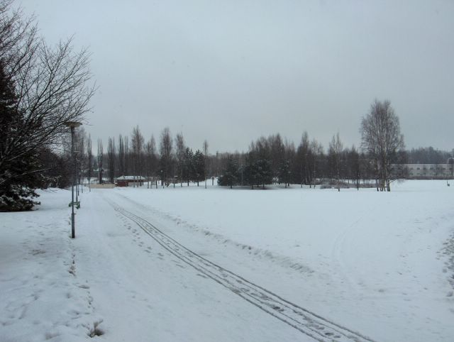
 Edelliseen kuvaan verrattuna tässä jatkui edelleen samantyyppinen pilvinen ja sateinen sää kahden eri ilmamassan rajalla ja matalapaineen kielekkeen ulottuessa lännen laajemmasta matalapaineesta eteläiseen Suomeen. Tänä päivänä etelätuuli oli kuitenkin ajoittain voimakkaampaa, mikä tiesi vähemmän sumua. Lämpötilat olivat lähes edellisen päivän luokkaa eli käytännössä läpi päivän vähän suojan puolella, mutta sadetta kertyi nyt vähemmän. Se näkyi mm. lumipeitteen aikaisempaa selvempänä sulamisena, kun vielä myös lumena tullut sade oli sen verran vähäistä. Näiden kahden päivän tilanteessa lumipeite suli nyt tasaisesti joka kohdasta, koska auringonsäteily ei päässyt vaikuttamaan pilvien vuoksi suoraan. Routa (n. 50cm) oli alkanut sulaa maan alta käsin, mikä on tyypillistä vielä lumipeitteisenä aikana. Säätilanne: valitse; 30.3.2006. Wetter3 A. Wetter3 B.As compared to the previous photo here was continuing further the same kind of weather in the borderline of two different air masses and where the strip of low pressure from the wider low pressure in the west was reaching southern Finland. However during this day southerly winds were occasionally stronger, which meant less fog. The temperatures were allmost as same as during the previous day. In other words slightly on the thaw side practically all day through, but there were now less precipitation. It showed as for example more obvious melting of the snowcover than before, when the amount of the precipitation yet as also snow was so small. In the situation of these two days the snowcover melted now evenly on every spot, because the radiation of the sun didn't have straight effect due to the clouds. The soil frost (about 50cm) had been started to melt from under ground, which is typical during yet snowcovered time. Weather condition: choose 30.3.2006; Wetter3 A. Wetter3 B.Helsingin Puistolan säätilasto maaliskuussa 2006 - Weather chart of Puistola, Helsinki in March 2006.Flickr 1 Flickr 2
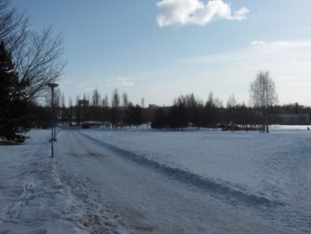
 Kuvassa oli satanut edellisen yön aikana märkää suojalunta parin sentin verran vanhan lumen päälle. Lumen märkyys näkyi mm. noiden tuoreiden jälkien tummasta sävystä puistokäytävällä. Päivä oli hyvin pilvinen (sade- ja sumupilvet) ja sateinen. Sademäärä oli päivän aikana 10,2mm, mutta lumipeite ei kasvanut kokonaisuudessaan juuri ollenkaan, koska lumisade oli niin märkää ja iltapäivällä satoi myös vettä ja tihkua. Lämpötilan vuorokausivaihtelu oli nyt pieni (alin -0,5 ja ylin +1,5 astetta) erittäin pilvisen sää vuoksi ja tuuli oli heikkoa, mistä aiheutui myös paikoin sumua. Tilanteessa eteläisen Suomen ylle ulottui lännen laajasta matalapaineesta kieleke, jossa sen eteläpuolella oli keväisen lämmintä säätä ja pohjoispuolella vielä talvista ilmaa. Siten kuvauspaikalla sää oli nyt huomattavasti aikaisempaa lämpimämpää, vaikka 27. päivään asti lähes koko ajan poutaisena ja aurinkoisena jatkunut sää oli päättynyt. Edellisen säätyypin ilmamassan kylmyys näkyi juuri 27. päivään asti jatkuneina yöpakkasina (lämpötilat -10 ja -15 asteen välillä). Kevät oli vasta nyt puhkeamaisillaan. Säätilanne: valitse 29.3.2006; Wetter3 A. Wetter3 B.In the picture wet thaw snow had been fallen couple of centimetres on the top of the old snow during the night before. The wetness of the snow was revealed from the dark tone of those fresh tracks on the path in the park. The day was very cloudy (nimbostratus and stratus clouds) and rainy. The amount of precipitation was 10,2 mm during the day, but the snowcover as a whole didn't grow allmost at all, because the snowing was so wet and the precipitation came also in the form of rain and drizzle during the afternoon. The cycle of daytime and night temperature was now small (the minimum -0,5 C and the maximum +1,5 C) due to the very cloudy weather and winds were weak, which resulted also fog here and there. In the situation a strip from the wide low pressure in the west was reaching southern Finland, where southside of it was warm spring-like weather and northside of it was yet wintry air. So at the photoshooting scene the weather was now much warmer than before, allthough the dry and sunny weather that had been continued allmost all the time up to the 27th day had been ended. The coldness of the previous weather type's air mass showed as nightfrosts (temperatures between -10 C and -15 C), which continued exactly to the 27th day. The spring was allmost starting to unfold only now. Weather condition: choose 29.3.2006; Wetter3 A. Wetter3 B.Helsingin Puistolan säätilasto maaliskuussa 2006 - Weather chart of Puistola, Helsinki in March 2006.Flickr 1 Flickr 2
 Tämä oli kuvattu samana päivänä kuin edellinen kuva, mutta vain minuuttia myöhemmin. Kuvassa nähdään tilanteen kumpupilven varjon siirtyneen niin, että valaistustilanne oli tässä päinvastainen kuin edellisessä kuvassa. Meren kylmyys (Suomenlahti oli tässä vaiheessa melkein kokonaan jäässä) ja toisaalta mantereen lämpeneminen iltapäivällä synnytti jo heikon merituulen, missä näitä kumpupilviä ei esiintynyt meren yllä (kuvassa meri sijaitsee etuoikealla). Tämäkin oli yksi kevään merkki. Lunta oli satanut n. 3 senttiä lisää em. matalapaineen myötä parina edellisenä päivänä, mutta jonkin verran sulamistakin tapahtui edelleen etenkin tummilla lumipinnoilla ja kohtisuoraan auringon paistetta vastaan olevilla pinnoilla. Aurinko sulatti näitä kohtia jo usean asteen pakkasessakin ja kuvassa nähdäänkin sulamisvettä tuolla puistokäytävällä. Säätilanne: valitse 20.3.2006; Wetter3 A. Wetter3 B.This was pictured in the same day as the previous photo, but only one minute later. In the picture we see the cumulus cloud of the situation moved in such a way, that the lighting situation was here the opposite as compared to the previous photo. The coldness of the sea (The Gulf Of Finland was at this stage allmost completely frozen) and on the other hand the warming up of the continent during the afternoon created allready a weak sea breeze, where these cumulus clouds weren't appearing over the sea (in the picture the sea is situated slightly on the right side). This was also one sign of spring. There had been fallen new snow about 3cm during previous couple of days due to the mentioned low pressure, but some melting also happened further especially on dark snowsurfaces and on surfaces situated perpendicularly against the sunshine. The sun melted these spots allready even in several degrees of frost and so in the picture we see melting water on that path in the park. Weather condition: choose 20.3.2006; Wetter3 A. Wetter3 B.Helsingin Puistolan säätilasto maaliskuussa 2006 - Weather chart of Puistola, Helsinki in March 2006.Flickr 1 Flickr 2
 Kuun 17. päivän tienoilla Suomen yllä ollut korkeapaine alkoi vetäytyä länteen ja samalla luoteesta Suomen itäpuolelle liikkui voimistuva matalapaine. Päivälämpötila kävi kuun 17. päivänä ylimmillään +4,5 asteessa, mutta mainittu matalapaine toi voimakkaan pohjoistuulen myötä uudestaan huomattavan kylmää ilmaa koko Suomeen. Kuvassa taivaanrannassa nähdään aikaisemmin päivällä paikan ylittäneen lumikuuroalueen viimeisenä merkkinä untuvapilvivyöhykettä. Talvisesta säästä (ko. päivän päivälämpötila oli pakkasella -2,1 asteen verran ylimmilläänkin) huolimatta kevään tulo näkyi tässä vaiheessa esim. entistä yhä voimakkaampana auringonsäteilynä. Sen vaikutuksesta tässä kylmässä ilmamassassa syntyi jo tyypillisiä iltapäivän kumpupilviä. Tässä kuvassa ylempään kuvaan verrattuna oli tilanne, jossa yhden tällaisen pilven varjo peitti maisemaa. Säätilanne: valitse 20.3.2006; Wetter3 A. Wetter3 B.Around 17th of this month the high pressure over Finland started to withdraw towards the west and at the same time a strengthening low pressure was moving from the northwest to the easternside of Finland. The daytime temperature peaked at +4,5 C at highest at 17th of the month, but the mentioned low pressure brought again significantly cold air into whole Finland with a strong northerly wind. In the picture on the horizon we see a layer of cirrus clouds as a last sign of the snowshower area that crossed the area earlier in the day. Despite the wintry weather (This day's daytime temperature was -2,1 C freezing even at the highest) the arrival of spring was exposing itself for example as even stronger radiation of the sun than before. Due to that effect typical cumulus clouds of the afternoon were allready born in this cold air mass. In this picture as compared to the picture above there was a situation, where a shadow of the one this kind of cloud was blanketing the landscape. Weather condition: choose 20.3.2006; Wetter3 A. Wetter3 B.Helsingin Puistolan säätilasto maaliskuussa 2006 - Weather chart of Puistola, Helsinki in March 2006.Flickr 1 Flickr 2
 Vahva korkeapaine oli edelleen Suomen yllä ulottuen Venäjältä Atlantille. Itäkaakkoinen tuuli oli heikkoa ja sää päivällä jo vähän keväistä noiden sumupilvien vähennyttyä; ylin lämpötila oli kuitenkin vielä -1,9 astetta pakkasella. Edellisessä kuvassa sumupilvet olivat vielä paksuja, mutta yhtenä kevään merkkinä tässä nähdään voimistuneen auringon paisteen vaikutus, joka haihdutti sumupilviä jo melko hyvin pois päivän aikana. Routa oli tässä vaiheessa yhä n. 50cm syvää, joten suuria muutoksia ei enää ollut tullut pakkasista huolimatta. Lumipeitteen sulamista oli tapahtunut parhaiten aurinkoisilla etelärinteillä, joilla maa oli tässä vaiheessa jo paikoin paljastunut. Tyypillisesti maaliskuussa lumipeite muodostuu tällä tavalla epäyhtenäiseksi riippuen kunkin maan kohdan auringonvalon saannista. Säätilanne: valitse 15.3.2006. Wetter3 A. Wetter3 B.The strong high pressure was further over Finland reaching from Russia to Atlantic. A east-southeasterly wind was weak and the weather allready slightly springlike in the afternoon after those stratus clouds had been decreased; the maximun temperature was yet -1,9 C freezing though. In the previous picture the stratus clouds were thick, but in here we see as a one sign of spring the strengthened power of the sunshine's effect, which evaporated allready rather easily the stratus clouds away during the day. The soil frost was still at this stage about 50cm deep and therefore big changes hadn't been appeared anymore despite the frosts. The melting of the snowcover had been happened the best in sunny southern slopes, where the ground had allready been exposed locally. Typically during March the snowcover becomes in this way uneven depending of the sunlight supply on every spot of ground. Weather condition: choose 15.3.2006; Wetter3 A. Wetter3 B.Helsingin Puistolan säätilasto maaliskuussa 2006 - Weather chart of Puistola, Helsinki in March 2006.Flickr 1 Flickr 2
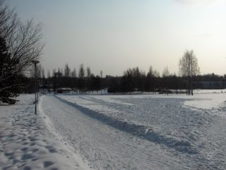
 Ajankohtaan nähden erittäin kylmä sääjakso oli hellittänyt hitaasti kuvan tilanteessa. Merkkinä ilmamassan lauhtumisesta taivaalla oli kerros sumupilviä. Niitä oli etelärannikolla tässä vaiheessa, koska leudomman ilmamassan virtaaminen kylmän alustan päälle loi olosuhteet sumulle ja sumupilville (loppusyksyllä ja talvella etenkin mantereella ja lumen sulettua etenkin meren ääressä keväällä ja alkukesällä) myös korkeapaineen piirissä etenkin tuulten oltua heikkoja. Hidas lauhtuminen aiheutui siis korkeapaineen vahvistumisesta lännestä Suomen itäpuolelle, jolloin lauhduttava kaakkoistuuli virisi vähän. Kuvassa nähdään, kuinka jo parina edellisenä päivänä lumi oli sulanut tuon puistokäytävän reunasta varsin tehokkaan auringon paisteen vaikutuksesta, kun päivälämpötilat olivat nollan tienoilla. Käytävä oli tummunut sulamisveden valuttua kuvaussuuntaan viettävää maastoa pitkin. Monin paikoin lumipeite oli kuitenkin vielä lähes sulamatta varjoisilta ja vaakasuorilta pinnoilta. Säätilanne: valitse 14.3.2006; Wetter3 A. Wetter3 B.The unseasonally very cold weather period had been eased slowly in the situation of the picture. As a mark for the milder progress of the weather there was a layer of stratus clouds in the sky. They appeared by the southern coast at this stage, because milder air flow over cold surface created conditions for fog and stratus clouds (during late autumn and winter especially in inland areas and after the snow melt in spring and early summer especially by the coast) also around the influence of a high pressure especially when winds were weak. So the slow process of getting milder was due to the high pressure strengthened from the west to the easternside of Finland, which caused the milder southeastern wind to pick up a bit. In the picture we see, how allready during the previous two days the snow had been melted beside that path in the park due to a rather effective sunshine, when the daytime temperatures were around zero C. The path had been darkened, when the melting water had been flowed along the slanting ground along the direction of the photoshoot. However in many places on horizontal and shadowy spots the snowcover allmost hadn't been melted yet. Weather condition: choose 14.3.2006; Wetter3 A. Wetter3 B.Helsingin Puistolan säätilasto maaliskuussa 2006 - Weather chart of Puistola, Helsinki in March 2006.Flickr 1 Flickr 2
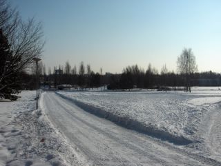 Talvi piti otetta edelleen merkittävästi ja kevään tulo oli estynyt kokonaan. Tämä johtui pitkään vaikuttaneen pakkasilmamassan jähmettymisestä paikalleen lähes tyynessä tilanteessa, missä korkeapaineen selänne lännessä esti Atlantin matalapaineiden vaikutuksen Suomeen. Ilmamassa ei vielä kokonaisuudessaan jaksanut lämmetä paikallaan ja siinä oli hajanaisia matalapaineita ympäri Suomen, joista satoi ajoittain vähän lunta. Välillä oli kuitenkin täysin selkeää kuvan tapaan. Ilmamassa oli myös hyvin kuivaa ja mantereista, josta johtuen yölämpötilat laskivat todella mataliksi selkeässä säässä; ko. yönä jopa -19,3 astetta alimmillaan. Aurinko lämmitti kuitenkin iltapäivän ilmaa yhä enemmän, joten lämpötilan vuorokausivaihtelu oli nyt hyvin suurta; ylin lämpötila oli -6,9 astetta. Talven kolmas ankaran pakkasen jakso oli tavallaan käynnissä, mutta siitä huolimatta tähän aikaan vuodesta juuri auringon keskipäivän lämmitys loi ihanteelliset olosuhteet talviurheiluun ja muuhun talviseen ulkoiluun. Siitä olivat merkkinä esim. kuvan lumihangen lisääntyneet jäljet lasten hiihtämisen jäljiltä. Säätilanne: valitse 8.3.2006; Wetter3 A. Wetter3 B.Winter held the grip further signifigantly and the arrival of spring was completely prevented. This was due to the long affecting frosty air mass stuck in place during an allmost still wind situation, where a ridge of high pressure in the west was blocking the influence of the low pressures of Atlantic towards Finland. The air mass as a whole didn't had yet the capasity to warm up in place and in there was dispersed low pressures around Finland, which gave a little snowing occasionally. However from time to time it was completely clear like in the photo. The air mass was also very dry and continental, which meant that the night temperatures dropped really low during clear weather; even -19,3 C at the lowest at this night. However the sun was warming up the afternoon air ever more and therefore the cycle of night and daytime temperature was now very big; the maximum temperature was -6,9 C. The third period of severe frost during this winter was ongoing in a way, but despite of that in this time of the year just the warming effect of the sun at noon created essential circumstances for winter sports and other wintry outdoor activities. As a mark for that in the picture there is increased tracks on the snowcover as a result of skeeing by children for example. Weather condition: choose 8.3.2006; Wetter3 A. Wetter3 B.Helsingin Puistolan säätilasto maaliskuussa 2006 - Weather chart of Puistola, Helsinki in March 2006.Flickr 1 Flickr 2
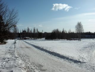
 Sää oli seljennyt yön jälkeen ja tuuli tyyntynyt kuvauspäiväksi. Edelleen oli ajankohtaan nähden kylmää, vaikka lämpötilat olivat nyt vähän korkeampia kuin aikaisemmin; alin -11,5 ja ylin -4,2 astetta. Heikot matalapaineet olivat yhä edelleen keskittyneet lähinnä Suomen etelä- ja itäpuolelle, jolloin arktinen pakkasilma jäi heikkotuulisessa tilanteessa paikalleen vaikuttamaan. Auringolla oli kuitenkin nyt niin paljon voimaa, että iltapäivän useiden asteiden pakkasessakin lumihangen tummat kohdat sulivat kohtalaisesti. Lumipeite oli kuitenkin edelleen lähes muuttumaton vähäisistä sateistakin johtuen. Lisääntynyt auringonvalo merkitsi nyt myös sitä, että tämä hanki loisti auringon paisteessa hyvin häikäisevästi. Se on yksi tyypillinen merkki alkavasta keväästä, vaikka sää olikin vielä hyvin talvinen. Säätilanne: valitse 6.3.2006; Wetter3 A. Wetter3 B.The weather had been cleared after the night and the wind had been died out until the photoshooting day. It was further cold considering the time of the year, allthough temperatures were a bit higher than before; the minimum -11,5 C and the maximum -4,2 C. Weak low pressures were still gathered mostly southern and eastern side of Finland and therefore in the weakly windy situation the arctic frosty air stayed in place affecting further. However the sun had now so much power, that even during several degrees of frost in the afternoon the dark spots of the snowcover melted moderately. The snowcover was allmost unchaged though due to also a very minor amount of precipitation. Now the increased amount of sunlight meant also, that this snowcover glowed very blindingly in the shine of the sun. It is one typical sign of the starting spring, allthough the weather was further very wintry. Weather condition: choose 6.3.2006; Wetter3 A. Wetter3 B.Helsingin Puistolan säätilasto maaliskuussa 2006 - Weather chart of Puistola, Helsinki in March 2006.Flickr 1 Flickr 2
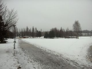
 Talvi ei antanut ollenkaan periksi, vaikka maaliskuu oli jo alkanut. Tässä tilanteessa Suomen eteläpuolelle oli muodostunut pitkä sarja matalapaineita pitkältä Atlantilta saakka ja samaan aikaan Venäjältä ulottui korkeapaineen selänne Pohjois-Suomeen. Niinpä hyvin kylmä ja mantereinen itätuuli vallitsi, jossa oli mukana kosteutta etelän matalapaineen vaikutuksesta. Suomenlahti oli nyt melkein kokonaan jäässä, joten sillä oli vähän vaikutusta rannikon lumisateisiin. Kosteus ilmeni heikkona ajoittaisena lumisateena, jota satoi näin kylmän pakkasilman tapaan lähes olemattomista pilvistä; ne muistuttivat sumupilviä. Kuvassa nähdään, että aurinko kuulsi hyvin tämän utuisen sadekerroksen läpi. Tuuli ja sade pitivät tässä vaiheessa lämpötilan vuorokausivaihtelua kurissa; yölämpötila oli -13,7 astetta ja päivällä oli pakkasta -6,2 astetta. Aurinko ei tässä tilanteessa päässyt sulattamaan edes tummia hangen kohtia (kts. albedo), joten kevät tuntui olevan hyvin kaukana ajankohtaan nähden. Säätilanne: valitse 2.3.2006; Wetter3 A. Wetter3 B.Winter didn't give in at all, allthough March had allready been started. In this situation a long line of low pressures had been formed southside of Finland reaching far Atlantic and at the same time a ridge of high pressure reached northern Finland from Russia. Therefore a very cold and continental easterly wind prevailed, which had moisture among itself as affected by the southerly low pressure. The Gulf Of Finland was now allmost completely frozen and therefore it had little effect to the snowfalls by the coast. The moisture showed as a weak and occasional snowing, which fell typically of this kind of cold frosty air from allmost nonexistent clouds; they resembled stratus clouds. In the picture we see, that the sun glowed finely through the hazy layer of precipitation. The wind and the snowfall kept the cycle of night and daytime temperature under control at this stage; the temperature was -13,7 C at night and it was -6,2 C at highest during the afternoon. In this situation the sun didn't had a chance to melt even the dark spots (check albedo) of the snowcover and therefore the spring seemed to be very far away considering the time of the year. Weather condition: choose 2.3.2006; Wetter3 A. Wetter3 B.Helsingin Puistolan säätilasto maaliskuussa 2006 - Weather chart of Puistola, Helsinki in March 2006.Flickr 1 Flickr 2